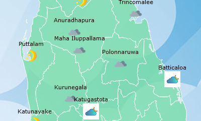
Weather
Showers above 75 mm are likely at some places in Northern and North-central provinces and in Trincomalee and Batticaloa districts
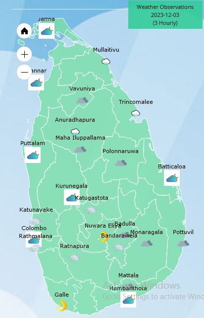
Weather forecast issued at 05.30 a.m.on 03 December 2023 by the Department of Meteorology
The Deep Depression over Southwest Bay of Bengal located near latitude 11.2°N and longitude 82.7°E, and about 330 km northeast of Jaffna at 2330hrs of 02 December will develop into a Cyclonic storm during next 12 hours. The system is moving away from the island near the northern coast of Sri Lanka, towards the North Tamil Nadu coast of India until December 04, 2023. Thereafter, it would move northwards as a Cyclonic Storm and cross South Andhra Pradesh coast on December 05, 2023.
Cloudy skies can be expected over Northern, North-central and Eastern provinces.
Showers may occur in Western and Sabaragamuwa provinces and in Galle, Matara, Kandy and Nuwara eliya districts during the morning while showers or thundershowers will occur at several places in Uva province and in Ampara and Hambantota districts after 01.00 p.m. Fairly heavy showers above 75 mm are likely at some places in Northern and North-central provinces and in Trincomalee and Batticaloa districts.
Strong winds about (40-50) kmph can be expected at times over the Northern, North-central, North-western and Southern provinces and in Trincomalee and Batticaloa districts.
Winds will be north-westerly or South- westerly and wind speed will be (30-40) kmph in the sea areas around the island. Wind speed may increase up to (60-70) kmph in the sea areas off the coast extending from Mannar to Pottuvil via Kankasanthurai, Trincomalee and Batticaloa and up to (50-60) kmph in the sea areas off the coast extending from Galle to Pottuvil via Hambantota.
The sea areas off the coast extending from Mannar to Pottuvil via Kankasanthurai, Trincomalee and Batticaloa will be very rough at times while the sea areas off the coast extending from Galle to Pottuvil via Hambantota can be rough at times and the other sea areas around the Island can be fairly rough at times. Temporarily strong gusty winds and very rough seas can be expected during thundershowers.
The general public is kindly requested to take adequate precautions to minimize damages caused by temporary localized strong winds and lightning during thundershowers


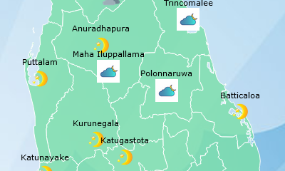


Weather
Showers in the Western, Sabaragamuwa and North-western provinces and in Galle, Matara, Kandy, Nuwara-Eliya, Anuradhapura and Mannar districts.

WEATHER FORECAST FOR 04 JULY 2026
Issued at 05.30 a.m. on 04 July 2026 by the Department of Meteorology
Showers will occur at times in the Western, Sabaragamuwa and North-western provinces and in Galle, Matara, Kandy and Nuwara-Eliya districts. Fairly heavy showers above 50 mm are likely at some places in these areas. Several spells of showers will occur in the Anuradhapura and Mannar districts.
Strong winds about (40-50) kmph can be expected at times over the Western slopes of the central hills, the Northern, North-central and North-western provinces and in Rathnapura, Hambantota and Trincomalee districts.
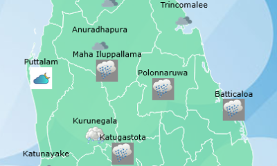
Weather
Showers will occur in the Western, Sabaragamuwa and North-western provinces and in Galle, Matara, Kandy, Nuwara-Eliya and Anuradhapura districts

WEATHER FORECAST FOR 03 JULY 2026
Issued at 05.30 a.m. on 03 July 2026 by the Department of Meteorology
Several spells of showers will occur in the Western, Sabaragamuwa and North-western provinces and in Galle, Matara, Kandy and Nuwara-Eliya districts. A few showers may occur in the Anuradhapura district.
Strong winds about (40-50) kmph can be expected at times over the Western slopes of the central hills, the Northern, North-central and North-western provinces and in Hambantota and Trincomalee districts.
Weather
A few showers will occur in the Western, Sabaragamuwa and North-western provinces and in Galle, Matara, Kandy and Nuwara-Eliya districts
WEATHER FORECAST FOR 02 JULY 2026
Issued at 05.30 a.m. on 02 July 2026 by the Department of Meteorology
A few showers will occur in the Western, Sabaragamuwa and North-western provinces and in Galle, Matara, Kandy and Nuwara-Eliya districts.
Strong winds about (40-50) kmph can be expected at times over the Western slopes of the central hills, the Northern, North-central and North-western provinces and in Hambantota and Trincomalee districts

Brutal heat cancels Fourth of July events, from DC to Philadelphia

Arias sends Colombia into World Cup last-16 with 1-0 win over Ghana

Messi scores again but Argentina given World Cup upset fright by Cape Verde

Anguished families left to identify Venezuela quake victims at makeshift morgue

Ukrainian suspect hunted by police after Monaco bomb attack was ‘disguised as a man’

Showers in the Western, Sabaragamuwa and North-western provinces and in Galle, Matara, Kandy, Nuwara-Eliya, Anuradhapura and Mannar districts.

‘Dates have the highest sugar content to fight Coronavirus’

Sunday Island 27 December – Headlines

#SundayIsland 17th December – Headlines

Sunday Island – 28th March

Sunday Island Headlines – 21 March

Sunday Island – 21st February – Headlines
-

 News5 days ago
LAWASIA warns against ad hoc initiative to increase judges’ retirement ages
-
 Features4 days ago
Climate action to bring South Asia together
-

 News4 days ago
Chamuditha to seek removal of injunction on Youtube programme
-

 News7 days ago
Another 1,132 Sri Lankan Personnel to be deployed for United Nations Peacekeeping Missions
-

 Features6 days ago
People’s Bank expands digital banking network with 125th cheque deposit kiosk
-

 News1 day ago
SLAF conducts successful rescue mission under UN command in Central African Republic
-

 News1 day ago
CIABOC to question Harak Kata on Rs. 200 mn bribery allegation
-

 News4 days ago
CPRP alleges another death in custody, seeks protection for witness