Features
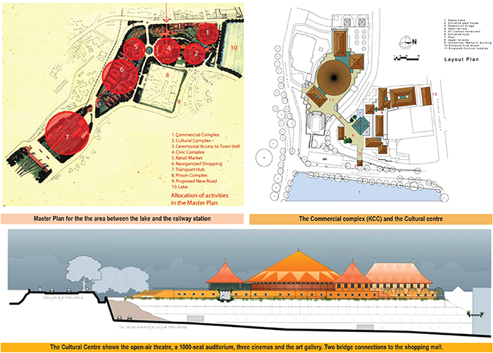
Master plan for sensitive area in Heritage City of Kandy
by Ashley de Vos
In 1994, the Department of Archaeology, The Central Cultural Fund and the Kandy Municipal Council held an open competition to develop a sensitive area in the heritage city of Kandy – the space between Bogambara Lake and the railway station. The competition was open for a specified time limit and Architect Geoffrey Bawa served as the jury’s Chairman.
The First prize in the open Master Plan competition was won by ADV Consultants. And the prize money of Rs. 300,000 was offered and of it Rs. 100,000 was received. For some reason, the UDA did not implement the original Master plan concept, as proposed in the Master plan. But some portions of the plan have been implemented intermittently, claiming to be others’ ideas.
There were some issues related to the Master plan that had to be respected and elucidated to arrive at a holistic concept for an important sensitive heritage city like Kandy. Our investigations showed Kandy has four problems: a high complement of buses parked on the roads, inadequate car parking in the city, the lack of a drainage system, and extra heavy development pressure on the inner city.
The first Visual pollution and impact on arrival in Kandy, is that it has been expanded to a great big bus stand. In the past, in the days of the bus depots, the vehicles retired to the depot for the night. However, under privatisation, the buses stayed on the roads, as close as possible to the stand, throughout the night, with the drivers and conductors sleeping in the bus. There had to be a drastic solution for the buses. The bus parking was unsightly, and a solution was found to change that. Is there a new location for the bus stand? There is no land available in the vicinity.
Could we create a Bus/Train transport terminal? The Railway Department owned about a couple hundred acres around the railway station, instead of looking for land and buying land rights. We, instead proposed a solution to buy air rights and raise the bus stand onto an elevated platform above the railway premises. Gopallawa and Peradeniya Mawatha could be easily reached from a raised platform. The bus stand would be raised on columns, and the railway could still function.
Upper terrace with direct access from the lake
Commuters arriving by train would go up and take a bus, and those coming by bus could go down and take the train. A large base platform, with perforated openings suitably placed to bring in light and ventilation, would ensure a pleasant environment for the trains’ passengers. All peripheral activity required for the commuter, like food kades and toilets, will be provided below and on the extended platform. This would ensure that no buses would be parked on the roads of Kandy, in the future. A commuter wishing to access other areas in the sacred city; would be encouraged to take the small shuttle buses, from the Bus/Train terminus, which would operate at a standard fixed fare.
With the buses off the road, there is a need to facilitate human movement through the space, without encountering any traffic. The need to safely take pilgrims from the Bus/Train terminus to the Temple of the Sacred Tooth Relic, could be easily achieved through an aerial-landscaped pedestrian precinct. Raised walkways would take passengers to where they wished to go. A total pedestrian movement from the Bus/Train terminus to the Temple of the Sacred Tooth Relic, is achievable.
Two attitudes toward shopping are proposed. An up-market shopping mall, with internal streets, for locals and tourists, and another for everyday shopping for the residents of Kandy, even incorporating and celebrating the traditional Pola, is also proposed, all conveniently accessible. The existing Kandy market is to be revamped, and the area beyond to have ‘U’ shaped shopping configurations with the central area of the ‘U’ heavily landscaped and the main shopping brought closer to the raised walkway with the open arms of the ‘U’ celebrating the landscaping closer to the peripheral road. This would permit those on the Ariel highway to access the shops easily and even walk through the shopping areas on the Aerial walkways. All the shops in the town could be moved into the new proposal.
The main shopping mall occupies the site of the demolished Walkers factory. To avoid the complex coming too close to the Dalada Veediya, the original Walkers showroom, on the main road, is preserved and converted to the Thorana entrance. As the side road encircles the Mall, while gradually descending to a lower level, several entrances are introduced to create a series of streets that penetrate the mall at different levels, and visitors are taken up or down to the required activity zones by the 16 escalators installed within. They eventually exit onto Dalada Veediya. The interior separations are glazed with no name boards in front to create the illusion of a single department store.
As children, one remembers sitting on the pavement of a friend’s house to watch the perahera. It was informal and a pleasant experience. Today all the houses have been taken over and converted into shops. If the new proposed shopping is implemented, all the shops could move out of the inner city, and the owners of the houses could return to live in their city. This would bring the original community, driven out, through the commercialisation of the city, back into the city. A city needs real people to be alive. If there are no people, it will be a dead city.
Kandy is small enough to be a pedestrian, walking city. Kandy parks about a thousand cars on its streets daily. The shopkeepers, who have taken over most of the residential buildings for shops, park their vehicles and fill up the roads today. The proposed site is a valley. We need to take full advantage of the levels. If one was to remove all the cars from the streets of Kandy, and introduce sufficient lower-level car parking, this would enhance the badly needed income for the KMC. On an estimation, parking over 3,000 cars in lower ground parking is possible. As there is no parking on the roads, it would be possible to reduce the width of the existing roads to two-lane roads and introduce wider pavements with shade trees. Walking the streets of Kandy, under the shade of spreading trees, would be a great experience.
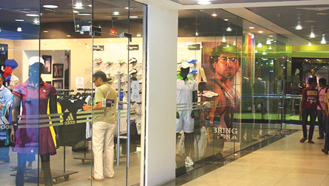
Typical shopping precinct, no signage on outside glass fronts create the illusion of one shop.
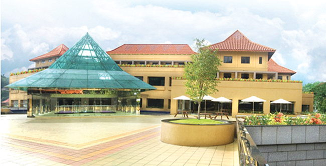
The Cultural Complex will stand on one of the multi-level car parks. The open-air theatre, at the upper level, will be orientated and have the lake as a backdrop. Kandy has no space for a theatre or a venue to hold large gatherings. On the upper terrace is a fully-fledged auditorium for 1,000 persons, an art gallery, and three small cinemas. The different levels are connected by flying bridges between the mall, the Cultural Complex and the Civic Centre. Instead, the KMC has introduced many small shops, on top of the car park, destroying the original concept.
The present Town Hall for Kandy is difficult to access and lacks a ceremonial aspect. The proposal is a new Civic Centre for Kandy, easily accessible from all roads, with ceremonial access to the Dalada Veediya for special events. The new Town Hall will occupy the space on which a cinema stands. The Town Hall stands above a large car park.
The prison complex occupies a large amount of land, which should be integrated into the Master plan proposal by introducing a circular road. A new compatible use should be found for the complex.
JAICA proposed a complete drainage system for the city. It may not be implemented.
While there are great possibilities for being in a valley, there were also development restrictions, like the roof of no building should be higher than the roof of the main temple and not penetrate below the base of the lake. The brief required the buildings to project some aspect of Kandyan architecture. This aspect was brought to focus, utilising the concept of the roof being the most prominent in the Kandyan landscape. The KMC opposed connecting the buildings because they were separate buildings and had separate approvals. They wanted users to descend to the ground and use the spaces as separate buildings. This was a total waste of human energy.
Though the competition was won in 1994, the final approval for the implementation from the KMC came in 2002. Prices had quadrupled. But the client went ahead with the project.
Architecture has nothing to do with buildings. It is to do with people. Communities and people make cities. People that cities manufacture are just artificial clones. They don’t even smile. These cities have lost their humanity. There is no human scale anymore. A good example is the cultureless cities of Dubai and Singapore, with the highest carbon footprint. When we imitate what they do, we are only cultureless copyists. We should know what to do, and what not to copy. “The architecture of Sri Lanka is not an architecture of buildings but of levels and canopies. At times, trees form the canopy” (de Vos 1982). It is not the case of copying the past, but bringing the spirit of the past to the contemporary.
An important aspect in developing sensitive World Heritage sites is that the colours, display panels, and advertising should not compete; they should all be subdued, colour coded, and the scale carefully controlled. Neon or similar lighting should never be used. Nothing should be hoisted on the external surface of the building. There is also a limit to the entertainment possibilities that should be introduced on a sensitive site. What is done inside is different, unless it impacts the outside. Any proposals for cars or similar systems flying out of a building should be discouraged. There is a need to respect the sensitivity of the sacredness of the environment, be economically viable and aid development in a controlled manner.


 by Kaushalya Perera
Time has, by and large, stood still in the business of academic staff recruitment to state universities. Qualifications have proliferated and evolved to be more interdisciplinary, but our selection processes and evaluation criteria are unchanged since at least the late 1990s. But before I delve into the problems, I will describe the existing processes and schemes of recruitment. The discussion is limited to UGC-governed state universities (and does not include recruitment to medical and engineering sectors) though the problems may be relevant to other higher education institutions (HEIs).
How recruitment happens currently in SL state universities
Academic ranks in Sri Lankan state universities can be divided into three tiers (subdivisions are not discussed).
* Lecturer (Probationary)
– recruited with a four-year undergraduate degree. A tiny step higher is the Lecturer (Unconfirmed), recruited with a postgraduate degree but no teaching experience.
* A Senior Lecturer can be recruited with certain postgraduate qualifications and some number of years of teaching and research.
* Above this is the professor (of four types), which can be left out of this discussion since only one of those (Chair Professor) is by application.
State universities cannot hire permanent academic staff as and when they wish. Prior to advertising a vacancy, approval to recruit is obtained through a mind-numbing and time-consuming process (months!) ending at the Department of Management Services. The call for applications must list all ranks up to Senior Lecturer. All eligible candidates for Probationary to Senior Lecturer are interviewed, e.g., if a Department wants someone with a doctoral degree, they must still advertise for and interview candidates for all ranks, not only candidates with a doctoral degree. In the evaluation criteria, the first degree is more important than the doctoral degree (more on this strange phenomenon later). All of this is only possible when universities are not under a ‘hiring freeze’, which governments declare regularly and generally lasts several years.
Problem type 1
– Archaic processes and evaluation criteria
Twenty-five years ago, as a probationary lecturer with a first degree, I was a typical hire. We would be recruited, work some years and obtain postgraduate degrees (ideally using the privilege of paid study leave to attend a reputed university in the first world). State universities are primarily undergraduate teaching spaces, and when doctoral degrees were scarce, hiring probationary lecturers may have been a practical solution. The path to a higher degree was through the academic job. Now, due to availability of candidates with postgraduate qualifications and the problems of retaining academics who find foreign postgraduate opportunities, preference for candidates applying with a postgraduate qualification is growing. The evaluation scheme, however, prioritises the first degree over the candidate’s postgraduate education. Were I to apply to a Faculty of Education, despite a PhD on language teaching and research in education, I may not even be interviewed since my undergraduate degree is not in education. The ‘first degree first’ phenomenon shows that universities essentially ignore the intellectual development of a person beyond their early twenties. It also ignores the breadth of disciplines and their overlap with other fields.
This can be helped (not solved) by a simple fix, which can also reduce brain drain: give precedence to the doctoral degree in the required field, regardless of the candidate’s first degree, effected by a UGC circular. The suggestion is not fool-proof. It is a first step, and offered with the understanding that any selection process, however well the evaluation criteria are articulated, will be beset by multiple issues, including that of bias. Like other Sri Lankan institutions, universities, too, have tribal tendencies, surfacing in the form of a preference for one’s own alumni. Nevertheless, there are other problems that are, arguably, more pressing as I discuss next. In relation to the evaluation criteria, a problem is the narrow interpretation of any regulation, e.g., deciding the degree’s suitability based on the title rather than considering courses in the transcript. Despite rhetoric promoting internationalising and inter-disciplinarity, decision-making administrative and academic bodies have very literal expectations of candidates’ qualifications, e.g., a candidate with knowledge of digital literacy should show this through the title of the degree!
Problem type 2 – The mess of badly regulated higher education
A direct consequence of the contemporary expansion of higher education is a large number of applicants with myriad qualifications. The diversity of degree programmes cited makes the responsibility of selecting a suitable candidate for the job a challenging but very important one. After all, the job is for life – it is very difficult to fire a permanent employer in the state sector.
Widely varying undergraduate degree programmes.
At present, Sri Lankan undergraduates bring qualifications (at times more than one) from multiple types of higher education institutions: a degree from a UGC-affiliated state university, a state university external to the UGC, a state institution that is not a university, a foreign university, or a private HEI aka ‘private university’. It could be a degree received by attending on-site, in Sri Lanka or abroad. It could be from a private HEI’s affiliated foreign university or an external degree from a state university or an online only degree from a private HEI that is ‘UGC-approved’ or ‘Ministry of Education approved’, i.e., never studied in a university setting. Needless to say, the diversity (and their differences in quality) are dizzying. Unfortunately, under the evaluation scheme all degrees ‘recognised’ by the UGC are assigned the same marks. The same goes for the candidates’ merits or distinctions, first classes, etc., regardless of how difficult or easy the degree programme may be and even when capabilities, exposure, input, etc are obviously different.
Similar issues are faced when we consider postgraduate qualifications, though to a lesser degree. In my discipline(s), at least, a postgraduate degree obtained on-site from a first-world university is preferable to one from a local university (which usually have weekend or evening classes similar to part-time study) or online from a foreign university. Elitist this may be, but even the best local postgraduate degrees cannot provide the experience and intellectual growth gained by being in a university that gives you access to six million books and teaching and supervision by internationally-recognised scholars. Unfortunately, in the evaluation schemes for recruitment, the worst postgraduate qualification you know of will receive the same marks as one from NUS, Harvard or Leiden.
The problem is clear but what about a solution?
Recruitment to state universities needs to change to meet contemporary needs. We need evaluation criteria that allows us to get rid of the dross as well as a more sophisticated institutional understanding of using them. Recruitment is key if we want our institutions (and our country) to progress. I reiterate here the recommendations proposed in ‘Considerations for Higher Education Reform’ circulated previously by Kuppi Collective:
* Change bond regulations to be more just, in order to retain better qualified academics.
* Update the schemes of recruitment to reflect present-day realities of inter-disciplinary and multi-disciplinary training in order to recruit suitably qualified candidates.
* Ensure recruitment processes are made transparent by university administrations.
Kaushalya Perera is a senior lecturer at the University of Colombo.
(Kuppi is a politics and pedagogy happening on the margins of the lecture hall that parodies, subverts, and simultaneously reaffirms social hierarchies.)

 This week, too, the spotlight is on an outfit that has gained popularity, mainly through social media.
Last week we had MISTER Band in our scene, and on 10th February, Yellow Beatz – both social media favourites.
Talento is a seven-piece band that plays all types of music, from the ‘60s to the modern tracks of today.
The band has reached many heights, since its inception in 2012, and has gained recognition as a leading wedding and dance band in the scene here.
The members that makeup the outfit have a solid musical background, which comes through years of hard work and dedication
Their portfolio of music contains a mix of both western and eastern songs and are carefully selected, they say, to match the requirements of the intended audience, occasion, or event.
Although the baila is a specialty, which is inherent to this group, that originates from Moratuwa, their repertoire is made up of a vast collection of love, classic, oldies and modern-day hits.
The musicians, who make up Talento, are:
Prabuddha Geetharuchi:

Geilee Fonseka: Dynamic and charismatic vocalist

Prabuddha Geetharuchi: The main man behind the band Talento
(Vocalist/ Frontman). He is an avid music enthusiast and was mentored by a lot of famous musicians, and trainers, since he was a child. Growing up with them influenced him to take on western songs, as well as other music styles. A Peterite, he is the main man behind the band Talento and is a versatile singer/entertainer who never fails to get the crowd going.
Geilee Fonseka (Vocals):
A dynamic and charismatic vocalist whose vibrant stage presence, and powerful voice, bring a fresh spark to every performance. Young, energetic, and musically refined, she is an artiste who effortlessly blends passion with precision – captivating audiences from the very first note. Blessed with an immense vocal range, Geilee is a truly versatile singer, confidently delivering Western and Eastern music across multiple languages and genres.
Chandana Perera (Drummer):
His expertise and exceptional skills have earned him recognition as one of the finest acoustic drummers in Sri Lanka. With over 40 tours under his belt, Chandana has demonstrated his dedication and passion for music, embodying the essential role of a drummer as the heartbeat of any band.
Harsha Soysa:
(Bassist/Vocalist). He a chorister of the western choir of St. Sebastian’s College, Moratuwa, who began his musical education under famous voice trainers, as well as bass guitar trainers in Sri Lanka. He has also performed at events overseas. He acts as the second singer of the band
Udara Jayakody:
(Keyboardist). He is also a qualified pianist, adding technical flavour to Talento’s music. His singing and harmonising skills are an extra asset to the band. From his childhood he has been a part of a number of orchestras as a pianist. He has also previously performed with several famous western bands.
Aruna Madushanka:
(Saxophonist). His proficiciency in playing various instruments, including the saxophone, soprano saxophone, and western flute, showcases his versatility as a musician, and his musical repertoire is further enhanced by his remarkable singing ability.
Prashan Pramuditha:
(Lead guitar). He has the ability to play different styles, both oriental and western music, and he also creates unique tones and patterns with the guitar..

The JJ Twins, the Sri Lankan musical duo, performing in the Maldives, and known for blending R&B, Hip Hop, and Sri Lankan rhythms, thereby creating a unique sound, have come out with a brand-new single ‘Me Mawathe.’
In fact, it’s a very special milestone for the twin brothers, Julian and Jason Prins, as ‘Me Mawathe’ is their first ever Sinhala song!
‘Me Mawathe’ showcases a fresh new sound, while staying true to the signature harmony and emotion that their fans love.
This heartfelt track captures the beauty of love, journey, and connection, brought to life through powerful vocals and captivating melodies.
It marks an exciting new chapter for the JJ Twins as they expand their musical journey and connect with audiences in a whole new way.
Their recent album, ‘CONCLUDED,’ explores themes of love, heartbreak, and healing, and include hits like ‘Can’t Get You Off My Mind’ and ‘You Left Me Here to Die’ which showcase their emotional intensity.
Readers could stay connected and follow JJ Twins on social media for exclusive updates, behind-the-scenes moments, and upcoming releases:
Instagram: http://instagram.com/jjtwinsofficial
TikTok: http://tiktok.com/@jjtwinsmusic
Facebook: http://facebook.com/jjtwinssingers
YouTube: http://youtube.com/jjtwins
Six US soldiers killed in Iranian strike on Kuwait base

Israel attacks presidential office in Tehran as reported death toll in Iran rises to 787

Attorney At Law S K Sangakkara pasess away

SriLankan Airlines Update on Middle East Operations

Trump says Iran war projected to last 4 to 5 weeks, could go ‘far longer’

Qatar downs two Iranian fighter jets as conflict widens

‘Dates have the highest sugar content to fight Coronavirus’

Sunday Island 27 December – Headlines

#SundayIsland 17th December – Headlines

Sunday Island – 28th March

Sunday Island Headlines – 21 March

Sunday Island – 21st February – Headlines
-

 Opinion5 days ago
Jamming and re-setting the world: What is the role of Donald Trump?
-

 Features5 days ago
An innocent bystander or a passive onlooker?
-

 Features6 days ago
Ratmalana Airport: The Truth, The Whole Truth, And Nothing But The Truth
-

 Business7 days ago
Dialog partners with Xiaomi to introduce Redmi Note 15 5G Series in Sri Lanka
-

 Features7 days ago
Building on Sand: The Indian market trap
-
 Opinion7 days ago
Future must be won
-
 Features2 days ago
Brilliant Navy officer no more
-

 Opinion2 days ago
Sri Lanka – world’s worst facilities for cricket fans