Weather
Heavy showers likely at some places in Western, Sabaragamuwa and Uva provinces and in Galle, Matara, Kandy and Nuwara-Eliya districts
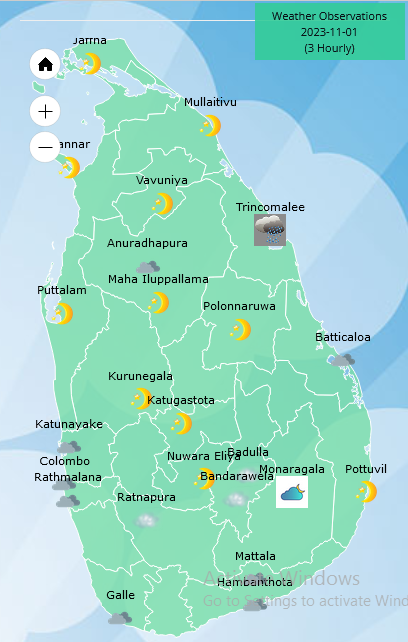
Weather forecast issued at 05.30 a.m. on 01 November 2023 by the Department of Meteorology
Showers will occur in Eastern, North-Central and Northwestern provinces and in Matale and Badulla districts during the morning while showers or thundershowers will occur at several places in most provinces of the island after 02.00PM. Heavy showers around 100mm are likely at some places in Western, Sabaragamuwa, and Uva provinces and in Galle, Matara, Kandy and Nuwara-Eliya districts.
Winds will be North-easternly or variable in direction and wind speed will be (20-25) kmph.
The sea areas around the island will be slight while temporarily strong gusty winds and very rough seas can be expected during thundershowers.
The general public is kindly requested to take adequate precautions to minimize damages caused by temporary localized strong winds and lightning during thundershowers.


Weather
Showers expected in the Western and Sabaragamuwa provinces and in Galle and Matara districts after 2.00 pm.

WEATHER FORECAST FOR 26 MARCH 2026
Issued at 05.30 a.m. on 26 March 2026 by the Department of Meteorology
Misty conditions can be expected at some places in the Central, Sabaragamuwa and Uva provinces and in Galle and Matara districts during the early hours of the morning.
Showers or thundershowers will occur at a few places in the Western and Sabaragamuwa provinces and in Galle and Matara districts after 2.00 pm. Dry weather will prevail over the other parts of the island.
The general public is kindly requested to take adequate precautions to minimize damages caused by temporary localized strong winds and lightning during thundershowers.
Latest News
Heat Index at ‘Caution level’ in the Western, Sabaragamuwa, Southern and North-western provinces and in Anuradhapura, Mannar, Vavuniya and Monaragala districts
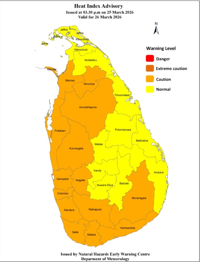
Warm Weather Advisory
Issued by the Natural Hazards Early Warning Centre of the Department of Meteorology
at 3.30 p.m. on 25 March 2026, valid for 26 March 2026.
The Heat index, the temperature felt on human body is likely to increase up to ‘Caution level’ at some places in the Western, Sabaragamuwa, Southern and North-western provinces and in
Anuradhapura, Mannar, Vavuniya and Monaragala districts.
The Heat Index Forecast is calculated by using relative humidity and maximum temperature and this is the condition that is felt on your body. This is not the forecast of maximum temperature. It is generated by the Department of Meteorology for the next day period and prepared by using global numerical weather prediction model data.
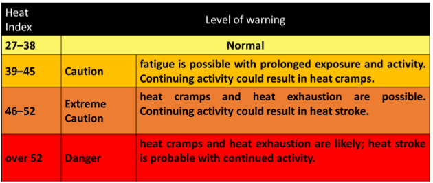
Effect of the heat index on human body is mentioned in the above table and it is prepared on the advice of the Ministry of Health and Indigenous Medical Services.
ACTION REQUIRED
Job sites: Stay hydrated and takes breaks in the shade as often as possible.
Indoors: Check up on the elderly and the sick.
Vehicles: Never leave children unattended.
Outdoors: Limit strenuous outdoor activities, find shade and stay hydrated.
Dress: Wear lightweight and white or light-colored clothing.
Note:
In addition, please refer to advisories issued by the Disaster Preparedness & Response Division, Ministry
of Health in this regard as well. For further clarifications please contact 011-7446491.
Weather
Showers will occur at several places in the Western and Sabaragamuwa provinces and in Galle and Matara districts after 2.00 pm
WEATHER FORECAST FOR 25 MARCH 2026
Issued at 05.30 a.m. on 25 March 2026 by the Department of Meteorology
Misty conditions can be expected at some places in the Western, Central, Sabaragamuwa and Uva provinces and in Galle and Matara districts during the early hours of the morning.
Showers or thundershowers will occur at several places in the Western and Sabaragamuwa provinces and in Galle and Matara districts after 2.00 pm. Dry weather will prevail over the other parts of the island.
The general public is kindly requested to take adequate precautions to minimize damages caused by temporary localized strong winds and lightning during thundershowers.

UN votes to recognise enslavement of Africans as ‘gravest crime against humanity’

Meta and YouTube found liable in landmark social media addiction trial

Showers expected in the Western and Sabaragamuwa provinces and in Galle and Matara districts after 2.00 pm.

Heat Index at ‘Caution level’ in the Western, Sabaragamuwa, Southern and North-western provinces and in Anuradhapura, Mannar, Vavuniya and Monaragala districts

US dodges question on AKD’s claim SL denied permission for military aircraft to land

No decrease in remittances from workers due to Gulf conflict, but significant drop in tourist arrivals – CB Governor

‘Dates have the highest sugar content to fight Coronavirus’

Sunday Island 27 December – Headlines

#SundayIsland 17th December – Headlines

Sunday Island – 28th March

Sunday Island Headlines – 21 March

Sunday Island – 21st February – Headlines
-
 Features3 days ago
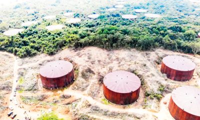
Trincomalee oil tank farm: An engineering marvel
-
 News6 days ago
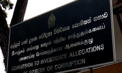
CIABOC tells court Kapila gave Rs 60 mn to MR and Rs. 20 mn to Priyankara
-

 Features6 days ago
Science and diplomacy in a changing world
-

 Features3 days ago
The scientist who was finally heard
-

 News1 day ago
Senior citizens above 70 years to receive March allowances on Thursday (26)
-
 News1 day ago
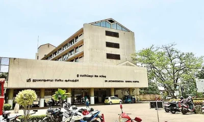
Japanese boost to Sri J’pura Hospital, an outright gift from Tokyo during JRJ rule
-

 News5 days ago
Colombo, Oslo steps up efforts to strengthen bilateral cooperation in key environmental priority areas
-

 News1 day ago
CEB Engineers warn public to be prepared for power cuts after New Year