Weather
Heavy showers above 100 mm are likely at some places in Northern province.

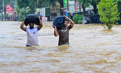
Weather forecast issued at 05.30 a.m. on 29 November 2024 by the Department of Meteorology
The deep depression over the southwest Bay of Bengal was located about 240 km northeast of Trincomalee and 290km east of Kankasanthurai around 11.30 p.m. of 28th November 2024. It is likely to move northwestwards, towards the Tamil Nadu coast. It can be expected that the influence of this system on the island’s weather will gradually reduce after today (29).
Showers or thundershowers will occur at times in Northern and North-central provinces and in Trincomalee district. Heavy showers above 100 mm are likely at some places in Northern province. Showers will occur at times in Western, Sabaragamuwa and North-western provinces and in Galle, Matara, Matale and Kandy districts. Showers or thundershowers will occur at several places elsewhere of the island in the evening or night.
Strong winds of about 60 kmph can be expected at times over Northern, North-central, North-western, Eastern, Central and Southern provinces.
Winds will be North-westerly to Westerly in the sea areas around the island and wind speed will be (40-50) kmph. Wind speed can increase up to (60-70) kmph at times in the sea areas extending from Puttalam to Batticaloa via Kankasanthurai and Trincomalee.
The sea areas extending from Puttalam to Batticaloa via Kankasanthurai and Trincomalee will be rough to very rough at times. The other sea areas around the island will be fairly rough at times.
The swell waves (about 2.5–3.0 m) height (this is not for land area) may increase in the sea areas off the coast extending from Batticaloa to Kankasanthurai via Trincomalee. There is a possibility that near shore sea areas off the coast extending from Batticaloa to Kankasanthurai via Trincomalee may experience surges due to swell waves. Strong gusty winds and very rough seas can be expected during thundershowers.
The general public is kindly requested to take adequate precautions minimize damages caused by temporary localized strong winds and lightning during thundershowers
Weather
A few showers will occur in the Western, Sabaragamuwa and North-western provinces and in Galle, Matara, Kandy and Nuwara-Eliya districts

WEATHER FORECAST FOR 02 JULY 2026
Issued at 05.30 a.m. on 02 July 2026 by the Department of Meteorology
A few showers will occur in the Western, Sabaragamuwa and North-western provinces and in Galle, Matara, Kandy and Nuwara-Eliya districts.
Strong winds about (40-50) kmph can be expected at times over the Western slopes of the central hills, the Northern, North-central and North-western provinces and in Hambantota and Trincomalee districts
Weather
Showers will occur in the Western, Sabaragamuwa and North-western provinces and in Galle, Matara, Kandy and Nuwara-Eliya districts.
WEATHER FORECAST FOR 01 JULY 2026
Issued at 05.30 a.m. on 01 July 2026 by the Department of Meteorology
Several spells of showers will occur in the Western, Sabaragamuwa and North-western provinces and in Galle, Matara, Kandy and Nuwara-Eliya districts. Showers or thundershowers may occur at a few places in the Uva province and in Ampara and Batticaloa districts after 2.00 p.m.
Strong winds about (40-50) kmph can be expected at times over the Western slopes of the central hills, the Northern, North-central and North-western provinces and in Hambantota and Trincomalee districts.
The general public is kindly requested to take adequate precautions to minimize damage caused by temporary localized strong winds and lightning during thundershowers.
Weather
Showers will occur at times in the Western, Sabaragamuwa and North-western provinces and in Galle, Matara, Kandy and Nuwara-Eliya districts

WEATHER FORECAST FOR 30 JUNE 2026
Issued at 05.30 a.m. on 30 June 2026by the Department of Meteorology
Showers will occur at times in the Western, Sabaragamuwa and North-western provinces and in Galle, Matara, Kandy and Nuwara-Eliya districts. Fairly heavy showers above 50 mm are likely at some places in these areas. Showers or thundershowers may occur at several places in the Uva province and in Ampara and Batticaloa districts after 2.00 p.m.
Strong winds of about (40-50) kmph can be expected at times over the Western, Sabaragamuwa, Central, Southern, North-central and Northwestern provinces and in Trincomalee district.
The general public is kindly requested to take adequate precautions to minimize damage caused by temporary localized strong winds and lightning during thundershowers.

Hope fit but Roach doubtful as West Indies eye series win

National Institute of Health Sciences celebrates a century of revolutionizing Public Healthcare Training in Sri Lanka – PM

IT, Electrical and Electronics sectors key to achieving 7–8% economic growth in coming years -President

Sri Lanka Cricket confirm dates for India Tests; tour to begin on August 15

Google must pay €4.1bn fine for using Android to ‘block’ rivals

England’s top three and South Africas quicks, both best in class, prepare for semi-final fight

‘Dates have the highest sugar content to fight Coronavirus’

Sunday Island 27 December – Headlines

#SundayIsland 17th December – Headlines

Sunday Island – 28th March

Sunday Island Headlines – 21 March

Sunday Island – 21st February – Headlines
-

 News4 days ago
LAWASIA warns against ad hoc initiative to increase judges’ retirement ages
-

 News5 days ago
Another 1,132 Sri Lankan Personnel to be deployed for United Nations Peacekeeping Missions
-

 News7 days ago
Kelaniya emerges as highest ranked Lankan uni in Times Higher Education Sustainability Impact Ratings
-

 News3 days ago
Chamuditha to seek removal of injunction on Youtube programme
-

 Business6 days ago
Month-end profit-takings drive stock trading; indices up
-

 Features5 days ago
People’s Bank expands digital banking network with 125th cheque deposit kiosk
-
 Features3 days ago
Climate action to bring South Asia together
-

 News6 days ago
FSP complains of irregularities in a Guinness World Record event held in Sri Lanka