Features
Recent earth tremors in Sri Lanka
– a critical review in relation with such activity in Tamil Nadu and the orogenesis of Himalayas based on a new theory of cratons and mobile belts in the Indian peninsular
By DULIP JAYAWARDENA
Former Director Geological Survey Department and retired Economic Affairs Officer, United Nations ESCAP
There were recent reports of earth tremors in the Buttala and Wellawaya areas in Sri Lanka and statements made by local earth scientists failed to give any scientific explanations as regards such activity.
An attempt is made to explain such activity in relation to seismicity in Sri Lanka compared to Tamil Nadu as well as the orogenesis of the Himalayas in relation to a new theory of cratons and fold belts in India and its extrapolation to Sri Lanka.
There was a news item in the local media that if a major earthquake occurs in the Himalayan region there will be tremors felt in Colombo as well as in Jaffna.
Historical seismicity in the Himalayan region has been analysed and its slip potential in the 21 Century recorded (Rodger Bilham roger.bilham@clorado.edu ).
The seismicity of Sri Lanka and Tamil Nadu are compared to understand mountain building in the two regions as Sri Lanka resemble crystalline metamorphic rocks of South India.
It is recommended that the theory cratons and mobile belts that has been postulated in India focusing on the Tamil Nadu region be extended to Sri Lanka to explain present earth tremors in Buttala and Wellawaya areas.
COMPARISON OF ALTITUDES AND SEISMIC RECORDS BETWEEN SRI LANKA AND TAMIL NADU
The highest mountains in Sri Lanka are Pidurutalagala (2524 metres msl), Kirigalpotha (2396 metres msl), and Samalakanda – Adam’s Peak (2243 metres msl)
As compared to Sri Lanka the heights of 77 mountains range from 2695 meters msl to 522 metres msl from the Indian Peninsular.
Tamil Nadu, which is a part of Peninsular India, compared to the highest peneplain of Sri Lanka (Wadia 1945), has three mountains namely Anamuda (2395 metres msl ) , Meesapullimala (2640 metres msl) and Kolabetta (2629 metres msl) -Wikipedia.
Accordingly, it is evident that the highest mountains in Sri Lanka can be closely related to those of Tamil Nadu subject to the same orogenesis or mountain building.
SEISMIC HAZARD ANALYSES FOR STATE OF TAMIL NADU SOUTH INDIA
A study by G. P. Ganapathy Assistant Professor, Centre for Disaster Mitigation and Management VIT University Vellore 632 014 Tamil Nadu India seismigans@yahoo.com and Rajaratnam S. Professor, Centre for Disaster Mitigation and Management, Anna University Chennai 600 025 Tamil Nadu, India ( drrajarathnam@yahoo.com ) have extensively analyzed seismic potential sources of Tamil Nadu State and are summarised in Table 2 of their paper titled, “Seismic Hazard Analyses for Tamil Nadu State: A Deterministic Approach “and published in the Jour. Engr. Geol. Vol.XXXV1 NO1.4
Tamil Nadu State covers 130 ,058 sq. km approximately twice the size of Sri Lanka which encompasses only 65 000 sq. km. Figure 1 gives a large number of lineaments which are seismic prone and it is interesting to note that such lineaments especially in the South Block may extend to Sri Lanka and Figure 2 indicate identified seismic potential sources in this block.
SEISMIC POTENTIAL SOURCES OF TAMIL NADU
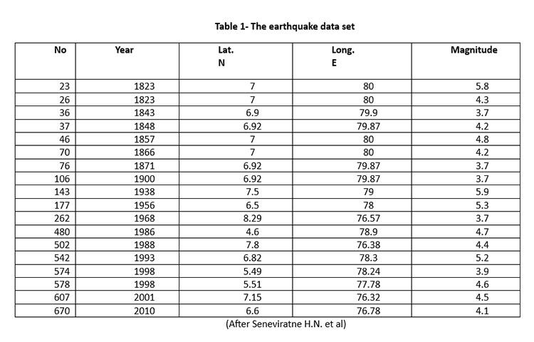 Table 1 of the above research paper analyses seven sources seismic potential sources with lengths varying from 315 km to 42 km with cumulative number of earthquakes ranging from 5 to 1 with magnitudes varying from 6.0 to 5.0 (M) observed from historical /instrumental earthquakes and peak ground acceleration (PGA) in g determined using m varying from 0.212 to 0.078 . It is noted that PGA is high in earthquakes with magnitude 6.0 and low in magnitude 3. Further PGA in Chennai, Coimbatore, Salem, Madurai and Tiruchirappalli cities varies from 0.107g, 0.133g, 0.012g ,0.77g and 0.113 g respectively. It is noted that the southeastern part of the State shows high values because of a high earthquake data for the years 1800 to 2004 It also explains that the southern part of the State which may extend to Sri Lanka shows comparatively low seismic hazards.
SEISMIC RECORDS AND POTENTIAL OF SRI LANKA
It is reported that Sri Lanka had no seismic records up to 1800. However from the period 1615 to 1800 earthquakes were reported close to Sri Lanka in the northern Indian Ocean and Coimbatore- Nilgiri Hills. (Seneviratne H.N et al ( DOI :http://doi.org/10.4038/engineer.v53i2.7412)
Newspaper reports are available in the National Archives, Sri Lanka in 1882 ,1924, 1938 and 1944(Ceylon Observer) on earthquakes that had occurred during these years. However no deaths have been reported although there was damage to property (Gunasekera K.W (2000) Sunday Observer ,p34)
Seismic records from 1909 to 1992 were from a seismograph installed in 1909. However, no data are available since 1992 as it was not fully functional.
It is reported that from the year 1823 to 2010 earth tremors and earthquakes in Sri Lanka varied from 5.9 to 3.7 on the Richter Scale and most of such tremors were recorded in the Comorin Ridge Failed Mannar Rift Zone (Seneviratne et.al).
Sri Lanka has been identified as a Mid Plate Platelet lying between Antarctica -India -Africa and Madagascar ( Curry 1984 adopted by Crawford (1974 )and Katz (1978).
In 1823 there was an earthquake of 5.8 Magnitude at Mandawela , in close proximity of Colombo with coordinates 7deg. Lat. and 80 deg. Long. There were no deaths but damage to property were recorded. There was also an earthquake of 5.9 Magnitude at Lat. N 6.5 and Long 79 E close to Kurunegala.
It is interesting to note that Sri Lanka within a latitude of 7.8731 deg. North and 80.7718 East had 18 earthquakes or tremors between the period 1823 to 2010 a period of 187 years. However, the number of tremors of insignificant nature during this period was 670.
SEISMIC RECORDS IN SRI LANKA AFTER 1992
-
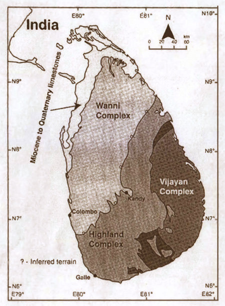
- Fig. 1. Schematic geological map of Sri Lanka, after Kroner et al 2013
-
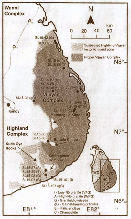
- Fig. 2. Map of Vijyana Complex with locations of sampling, edited after Kroner et al 2013. The tectonic mixed zone between the Highland Complex and the Vijayan Complex is highlighted as light-grey in colour.
The Geological Survey and Mines Bureau (GSMB) commissioned three seismometers, one at Pallekelle in year 2000 (PALK) connected to the Global Seismic Network (GSN)and the others in 2010 Mahakandarawa (MALK) connected to GEOFON) Network and Hakmana (HALK)connected to GEOFON (Geo-Network operated by Germany).
It is of importance that a network of seismometers be established in Colombo and the Western Province and a network of seismometers covering the entire Island to establish relationship between earthquakes and development activity accelerated recently in Sri Lanka. (Senaviratne H.N. et. al. 2020)
It has also been revealed that an earthquake of magnitude 6.9 (475-year return period) along the Mannar Rift Zone identified earlier in this report.
SRI LANKA HAS THE LOWEST GRAVITY RECORDED IN THE WORLD
The European Space Agency (ESA) carried out a four-and-a-half-year Gravity Field and Steady – State Ocean Circulation Explorer (GOCE) mission to learn what constitutes the surface beneath the Earth and discovered that the lowest negative gravity was south of Sri Lanka.
A geoid is the equipotential surface that coincides over the oceans with the same sea level. It is noted that the earth becomes flattened around the equator and the distance from equatorial areas to the center of the Earth is more than from the poles to the center. (Roar media Sachith Mendis (https://roar.media/english/life/reports/sri-lanka-least-earth-place-world )
It is also revealed that launching of space satellites will be much cheaper due the low gravity and due to no land surface directly south of Sri Lanka.
EARTHQUAKE OF 1615 IN SRI LANKA
An earthquake of magnitude 8 or 9 on the Richter scale was reported on 14 April 1615 evening offshore that caused extensive damage in western part of the Island. The worst hit area was Colombo and 2 per cent of Colombo Fort was destroyed. It has been reported that nearly 200 houses were destroyed with nearly 2000 casualties. Accordingly, moderate sized earthquakes cannot be ruled out in Sri Lanka. (Muhandiram P. M. S. S. B. <https: loes18.wildapricot.org/article _earthquakes-text= According to this document2 % of Colombo Fort got destroyed.
GRAVITY MAP OF SRI LANKA
A Gravity Map of Sri Lanka was compiled and produced in 1975 by the Geological Survey Department (present GSMB) on the scale of 1: 1. 000,000 by T. Hatherton, D. B. Pattiarachchi and V. V. C. Ranasinghe with an appendix by R.B. Evans.
A total of 1,170 points were established covering the whole Island in respect to 19 base stations and about 87 per cent of observations where in areas less than 150 meters msl.
The horizontal distance and heights of the 1971 gravity observations were from 1 -inch topographic maps covering Sri Lanka.
Most of these gravity stations were tied up with the trigonometrical survey stations of the Survey Department. When these stations were opened it was revealed that there was movement due to upliftment.
A contour map of complete Bouguer (gravity anomaly corrected to the height of its measurement) anomalies with the locations of gravity observations was produced.
The gravity map has revealed a negative gravity low on the Highland -Vijayan boundary in the east of Sri Lanka.
(To be concluded)

(This is the 100th column of the Out of the Box series, which began on 6 September, 2023, at the invitation of this newspaper – Ed.)
A new year is an appropriate moment to pause, not for celebration, but to interrogate what our politics, policies, and public institutions have chosen to remember, forget, and repeat. We celebrate the dawn of another brand-new year. But whose calendar defines this moment?
We hang calendars on our walls and carry them in our phones, trusting them to keep our lives in order, meetings, exams, weddings, tax deadlines, pilgrimages. Yet calendars are anything but neutral. They are among humanity’s oldest instruments of power: tools that turn celestial rhythms into social rules and convert culture into governance. In Sri Lanka, where multiple traditions of time coexist, the calendar is not just a convenience, it is a contested terrain of identity, authority, and fairness.
Time is never just time
Every calendar expresses a political philosophy. Solar systems prioritise agricultural predictability and administrative stability; lunar systems preserve religious ritual even when seasons drift; lunisolar systems stitch both together, with intercalary months added to keep festivals in season while respecting the moon’s phases. Ancient India and China perfected this balancing act, proving that precision and meaning can coexist. Sri Lanka’s own rhythms, Vesak and Poson, Avurudu in April, Ramadan, Deepavali, sit inside this wider tradition.
What looks “technical” is actually social. A calendar decides when courts sit, when budgets reset, when harvests are planned, when children sit exams, when debts are due, and when communities celebrate. It says who gets to define “normal time,” and whose rhythms must adapt.
The colonial clock still ticks
Like many postcolonial societies, Sri Lanka inherited the Gregorian calendar as the default language of administration. January 1 is our “New Year” for financial statements, annual reports, contracts, fiscal plans, school terms, and parliamentary sittings, an imported date shaped by European liturgical cycles and temperate seasons rather than our monsoons or zodiac transitions. The lived heartbeat of the island, however, is Avurudu: tied to the sun’s movement into Mesha Rāshi, agricultural renewal, and shared rituals of restraint and generosity. The result is a quiet tension: the calendar of governance versus the calendar of lived culture.
This is not mere inconvenience; it is a subtle form of epistemic dominance. The administrative clock frames Gregorian time as “real,” while Sinhala, Tamil, and Islamic calendars are relegated to “cultural” exceptions. That framing shapes everything, from office leave norms to the pace at which development programmes expect communities to “comply”.
When calendars enforce authority
History reminds us that calendar reforms are rarely innocent. Julius Caesar’s reshaping of Rome’s calendar consolidated imperial power. Pope Gregory XIII’s reform aligned Christian ritual with solar accuracy while entrenching ecclesiastical authority. When Britain finally adopted the Gregorian system in 1752, the change erased 11 days and was imposed across its empire; colonial assemblies had little or no say. In that moment, time itself became a technology for governing distant subjects.
Sri Lanka knows this logic. The administrative layers built under colonial rule taught us to treat Gregorian dates as “official” and indigenous rhythms as “traditional.” Our contemporary fiscal deadlines, debt restructurings, even election cycles, now march to that imported drumbeat, often without asking how this timing sits with the island’s ecological and cultural cycles.
Development, deadlines and temporal violence
Modern governance is obsessed with deadlines: quarters, annual budgets, five-year plans, review missions. The assumption is that time is linear, uniform, and compressible. But a farmer in Anuradhapura and a rideshare driver in Colombo do not live in the same temporal reality. Monsoons, harvests, pilgrimage seasons, fasting cycles, school term transitions, these shape when people can comply with policy, pay taxes, attend trainings, or repay loans. When programmes ignore these rhythms, failure is framed as “noncompliance,” when in fact the calendar itself has misread society. This mismatch is a form of temporal violence: harm produced not by bad intentions, but by insensitive timing.
Consider microcredit repayment windows that peak during lean agricultural months, or school examinations scheduled without regard to Avurudu obligations. Disaster relief often runs on the donor’s quarterly clock rather than the community’s recovery pace. In each case, governance time disciplines lived time, and the least powerful bend the most.
Religious time vs administrative time
 Sri Lanka’s plural religious landscape intensifies the calendar question. Buddhism, Hinduism, Islam, and Christianity relate to time differently: lunar cycles, solar markers, sacred anniversaries. The state acknowledges these mainly as public holidays, rather than integrating their deeper temporal logic into planning. Vesak is a day off, not a rhythm of reflection and restraint; Ramadan is accommodated as schedule disruption, not as a month that reorganises energy, sleep, and work patterns; Avurudu is celebrated culturally but remains administratively marginal. The hidden assumption is that “real work” happens on the Gregorian clock; culture is decorative. That assumption deserves challenge.
The wisdom in complexity
Precolonial South and East Asian calendars were not confused compromises. They were sophisticated integrations of astronomy, agriculture, and ritual life, adding intercalary months precisely to keep festivals aligned with the seasons, and using lunar mansions (nakshatra) to mark auspicious thresholds. This plural logic admits that societies live on multiple cycles at once. Administrative convenience won with the Gregorian system, but at a cost: months that no longer relate to the moon (even though “month” comes from “moon”), and a yearstart with no intrinsic astronomical significance for our context.
Towards temporal pluralism
The solution is not to abandon the Gregorian calendar. Global coordination, trade, aviation, science, requires shared reference points. But ‘shared’ does not mean uncritical. Sri Lanka can lead by modelling temporal pluralism: a policy posture that recognises different ways of organising time as legitimate, and integrates them thoughtfully into governance.
Why timing is justice
In an age of economic adjustment and climate volatility, time becomes a question of justice: Whose rhythms does the state respect? Whose deadlines dominate? Whose festivals shape planning, and whose are treated as interruptions? The more governance assumes a single, imported tempo, the wider the gap between the citizens and the state. Conversely, when policy listens to local calendars, legitimacy grows, as does efficacy. People comply more when the schedule makes sense in their lives.
Reclaiming time without romanticism
This is not nostalgia. It is a pragmatic recognition that societies live on multiple cycles: ecological, economic, ritual, familial. Good policy stitches these cycles into a workable fabric. Poor policy flattens them into a grid and then blames citizens for falling through the squares.
Sri Lanka’s temporal landscape, Avurudu’s thresholds, lunar fasts, monsoon pulses, exam seasons, budget cycles, is rich, not chaotic. The task before us is translation: making administrative time converse respectfully with cultural time. We don’t need to slow down; we need to sync differently.
The last word
When British subjects woke to find 11 days erased in 1752, they learned that time could be rearranged by distant power. Our lesson, centuries later, is the opposite: time can be rearranged by near power, by a state that chooses to listen.
Calendars shape memory, expectation, discipline, and hope. If Sri Lanka can reimagine the governance of time, without abandoning global coordination, we might recover something profound: a calendar that measures not just hours but meaning. That would be a reform worthy of our island’s wisdom.
(The writer, a senior Chartered Accountant and professional banker, is Professor at SLIIT, Malabe. The views and opinions expressed in this article are personal.)

The recent wave of pharmaceutical tragedies in Sri Lanka, as well as some others that have occurred regularly in the past, has exposed a terrifying reality: our medicine cabinets have become a frontline of risk and potential danger. In recent months, the silent sanctuary of Sri Lanka’s healthcare system has been shattered by a series of tragic, preventable deaths. The common denominator in these tragedies has been a failure in the most basic promise of medicine: that it will heal, not harm. This issue is entirely contrary to the immortal writings of the Father of Medicine, Hippocrates of the island of Kos, who wrote, “Primum non nocere,” which translates classically from Latin as “First do no harm.” The question of the safety of medicinal drugs is, at present, a real dilemma for those of us who, by virtue of our vocation, need to use them to help our patients.
For a nation that imports the vast majority of its medicinal drugs, largely from regional hubs like India, Pakistan, and Bangladesh, the promise of healing is only as strong as the laboratory that verifies these very same medicinal drugs. To prevent further problems, and even loss of lives, we must demand a world-class laboratory infrastructure that operates on science, not just sentiment. We desperately need a total overhaul of our pharmaceutical quality assurance architecture.
The detailed anatomy of a national drug testing facility is not merely a government office. It is a high-precision fortress. To meet international standards like ISO/IEC 17025 and World Health Organisation (WHO) Good Practices for Pharmaceutical Quality Control Laboratories, such a high-quality laboratory must be zoned into specialised units, each designed to catch a different type of failure.
* The Physicochemical Unit: This is where the chemical identity of a drug is confirmed. Using High-Performance Liquid Chromatography (HPLC) and Gas Chromatography-Mass Spectrometry (GC-MS), scientists determine if a “500mg” tablet actually contains 500mg of the active ingredient or if it is filled with useless chalk.
* The Microbiology Suite: This is the most critical area for preventing “injection deaths.” It requires an ISO Class 5 Cleanroom: sterile environments where air is filtered to remove every microscopic particle. Here, technicians perform Sterility Testing to ensure no bacteria or fungi are present in medicines that have to be injected.
* The Instrumentation Wing: Modern testing requires Atomic Absorption Spectrometers to detect heavy metal contaminants (like lead or arsenic) and Stability Chambers to see how drugs react to Sri Lanka’s high humidity.
* The injectable drug contamination is a serious challenge. The most recent fatalities in our hospitals were linked to Intravenous (IV) preparations. When a drug is injected directly into the bloodstream, there is no margin for error. A proper national laboratory must conduct two non-negotiable tests:
* Bacterial Endotoxin Testing (BET): Even if a drug is “sterile” (all bacteria are dead), the dead bacteria leave behind toxic cell wall products called endotoxins. If injected, these residual compounds cause “Pyrogenic Reactions” with violent fevers, organ failure, and death. A functional lab must use the Limulus Amoebocyte Lysate (LAL) test to detect these toxins at the parts-per-billion level.
* Particulate Matter Analysis: Using laser obscuration, labs must verify that no microscopic shards of glass or plastic are floating in the vials. These can cause fatal blood clots or embolisms in the lungs.
It is absolutely vital to assess whether the medicine is available in the preparation in the prescribed amounts and whether it is active and is likely to work. This is Bioavailability. Sri Lanka’s heavy reliance on “generic” imports raises a critical question: Is the cheaper version from abroad as effective as the original, more expensive branded formulation? This is determined by Bioavailability (BA) and Bioequivalence (BE) studies.
A drug might have the right chemical formula, but if it does not dissolve properly in the stomach or reach the blood at the right speed, it is therapeutically useless. Bioavailability measures the rate and extent to which the active ingredient is absorbed into the bloodstream. If a cheaper generic drug is not “bioequivalent” to the original brand-named version, the patient is essentially taking a useless placebo. For patients with heart disease or epilepsy, even a 10% difference in bioavailability can lead to treatment failure. A proper national system must include a facility to conduct these studies, ensuring that every generic drug imported is a true “therapeutic equivalent” to the brand-named original.
As far as testing goes, the current testing philosophy is best described as Reactive, rather than Proactive. The current Sri Lankan system is “reactive”: we test a drug only after a patient has already suffered. This is a proven recipe for disaster. To protect the public, we must shift to a Proactive Surveillance Model of testing ALL drugs at many stages of their dispensing.
* Pre-Marketing Approval: No drug should reach a hospital shelf without “Batch Release” testing. Currently, we often accept the manufacturer’s own certificate of analysis, which is essentially like allowing students to grade their own examination answers.
* Random Post-Marketing Surveillance (PMS): Regulatory inspectors must have the power to walk into any rural pharmacy or state hospital, pick a box of medicine at random, and send it to the lab. This could even catch “substandard” drugs that may have degraded during shipping or storage in our tropical heat. PMS is the Final Safety Net. Even the best laboratories cannot catch every defect. Post-Marketing Surveillance is the ongoing monitoring of a drug’s safety after it has been released to the public. It clearly is the Gold Standard.
* Pharmacovigilance: A robust digital system where every “Adverse Drug Reaction” (ADR) is logged in a national database.
* Signal Detection: An example of this is if three hospitals in different provinces report a slight rash from the same batch of an antibiotic, the system should automatically “flag” that batch for immediate recall before a more severe, unfortunate event takes place.
* Testing for Contaminants: Beyond the active ingredients, we must test for excipient purity. In some global cases, cheaper “glycerin” used in syrups was contaminated with diethylene glycol, a deadly poison. A modern lab must have the technology to screen for these hidden killers.
When one considers the Human Element, Competence and Integrity, the very best equipment in the world is useless without the human capital to run it. A national lab would need the following:
* Highly Trained Pharmacologists and Microbiologists and all grades of staff who are compensated well enough to be immune to the “lobbying” of powerful external agencies.
* Digital Transparency: A database accessible to the public, where any citizen can enter a batch number from their medicine box and see the lab results.
Once a proper system is put in place, we need to assess as to how our facilities measure up against the WHO’s “Model Quality Assurance System.” That will ensure maintenance of internationally recognised standards. The confirmed unfavourable results of any testing procedure, if any, should lead to a very prompt “Blacklist” Initiative, which can be used to legally bar failing manufacturers from future tenders. Such an endeavour would help to keep all drug manufacturers and importers on their toes at all times.
This author believes that this article is based on the premise that the cost of silence by the medical profession would be catastrophic. Quality assurance of medicinal compounds is not an “extra” cost. It is a fundamental right of every Sri Lankan citizen, which is not at all subject to any kind of negotiation. Until our testing facilities match the sophistication of the manufacturers we buy from, we are not just importing medicine; we are importing potential risk.
The promises made by the powers-that-be to “update” the testing laboratories will remain as a rather familiar, unreliable, political theatre until we see a committed budget for mass spectrometry, cleanroom certifications, highly trained and committed staff and a fleet of independent inspectors. Quality control of therapeutic medicines is not a luxury; it is the price to be paid for a portal of entry into a civilised and intensively safe healthcare system. Every time we delay the construction of a comprehensive, proactive testing infrastructure, we are playing a game of Russian Roulette with the lives of our people.
The science is available, and the necessary technology exists. What is missing is the political will to put patient safety as the premier deciding criterion. The time for hollow rhetoric has passed, and the time for a scientifically fortified, transparent, and proactive regulatory mechanism is right now. The good health of all Sri Lankans, as well as even their lives, depend on it.
 Dr B. J. C. Perera
MBBS(Cey), DCH(Cey), DCH(Eng), MD(Paediatrics), MRCP(UK), FRCP(Edin), FRCP(Lond), FRCPCH(UK), FSLCPaed, FCCP, Hony. FRCPCH(UK), Hony. FCGP(SL)
Specialist Consultant Paediatrician and Honorary Senior Fellow, Postgraduate Institute of Medicine, University of Colombo, Sri Lanka.
Joint Editor, Sri Lanka Journal of Child Health
Section Editor, Ceylon Medical Journal

In the immediate aftermath of Cyclone Ditwah, the government has moved swiftly to establish a Presidential Task Force for Rebuilding Sri Lanka with a core committee to assess requirements, set priorities, allocate resources and raise and disburse funds. Public reaction, however, has focused on the committee’s problematic composition. All eleven committee members are men, and all non-government seats are held by business personalities with no known expertise in complex national development projects, disaster management and addressing the needs of vulnerable populations. They belong to the top echelon of Sri Lanka’s private sector which has been making extraordinary profits. The government has been urged by civil society groups to reconsider the role and purpose of this task force and reconstitute it to be more representative of the country and its multiple needs.
The group of high-powered businessmen initially appointed might greatly help mobilise funds from corporates and international donors, but this group may be ill equipped to determine priorities and oversee disbursement and spending. It would be necessary to separate fundraising, fund oversight and spending prioritisation, given the different capabilities and considerations required for each. International experience in post disaster recovery shows that inclusive and representative structures are more likely to produce outcomes that are equitable, efficient and publicly accepted. Civil society, for instance, brings knowledge rooted in communities, experience in working with vulnerable groups and a capacity to question assumptions that may otherwise go unchallenged.
A positive and important development is that the government has been responsive to these criticisms and has invited at least one civil society representative to join the Rebuilding Sri Lanka committee. This decision deserves to be taken seriously and responded to positively by civil society which needs to call for more representation rather than a single representative. Such a demand would reflect an understanding that rebuilding after a national disaster cannot be undertaken by the state and the business community alone. The inclusion of civil society will strengthen transparency and public confidence, particularly at a moment when trust in institutions remains fragile. While one appointment does not in itself ensure inclusive governance, it opens the door to a more participatory approach that needs to be expanded and institutionalised.
Costly Exclusions
Going down the road of history, the absence of inclusion in government policymaking has cost the country dearly. The exclusion of others, not of one’s own community or political party, started at the very dawn of Independence in 1948. The Father of the Nation, D S Senanayake, led his government to exclude the Malaiyaha Tamil community by depriving them of their citizenship rights. Eight years later, in 1956, the Oxford educated S W R D Bandaranaike effectively excluded the Tamil speaking people from the government by making Sinhala the sole official language. These early decisions normalised exclusion as a tool of governance rather than accommodation and paved the way for seven decades of political conflict and three decades of internal war.
Exclusion has also taken place virulently on a political party basis. Both of Sri Lanka’s post Independence constitutions were decided on by the government alone. The opposition political parties voted against the new constitutions of 1972 and 1977 because they had been excluded from participating in their design. The proposals they had made were not accepted. The basic law of the country was never forged by consensus. This legacy continues to shape adversarial politics and institutional fragility. The exclusion of other communities and political parties from decision making has led to frequent reversals of government policy. Whether in education or economic regulation or foreign policy, what one government has done the successor government has undone.
Sri Lanka’s poor performance in securing the foreign investment necessary for rapid economic growth can be attributed to this factor in the main. Policy instability is not simply an economic problem but a political one rooted in narrow ownership of power. In 2022, when the people went on to the streets to protest against the government and caused it to fall, they demanded system change in which their primary focus was corruption, which had reached very high levels both literally and figuratively. The focus on corruption, as being done by the government at present, has two beneficial impacts for the government. The first is that it ensures that a minimum of resources will be wasted so that the maximum may be used for the people’s welfare.
Second Benefit
The second benefit is that by focusing on the crime of corruption, the government can disable many leaders in the opposition. The more opposition leaders who are behind bars on charges of corruption, the less competition the government faces. Yet these gains do not substitute for the deeper requirement of inclusive governance. The present government seems to have identified corruption as the problem it will emphasise. However, reducing or eliminating corruption by itself is not going to lead to rapid economic development. Corruption is not the sole reason for the absence of economic growth. The most important factor in rapid economic growth is to have government policies that are not reversed every time a new government comes to power.
For Sri Lanka to make the transition to self-sustaining and rapid economic development, it is necessary that the economic policies followed today are not reversed tomorrow. The best way to ensure continuity of policy is to be inclusive in governance. Instead of excluding those in the opposition, the mainstream opposition in particular needs to be included. In terms of system change, the government has scored high with regard to corruption. There is a general feeling that corruption in the country is much reduced compared to the past. However, with regard to inclusion the government needs to demonstrate more commitment. This was evident in the initial choice of cabinet ministers, who were nearly all men from the majority ethnic community. Important committees it formed, including the Presidential Task Force for a Clean Sri Lanka and the Rebuilding Sri Lanka Task Force, also failed at first to reflect the diversity of the country.
In a multi ethnic and multi religious society like Sri Lanka, inclusivity is not merely symbolic. It is essential for addressing diverse perspectives and fostering mutual understanding. It is important to have members of the Tamil, Muslim and other minority communities, and women who are 52 percent of the population, appointed to important decision making bodies, especially those tasked with national recovery. Without such representation, the risk is that the very communities most affected by the crisis will remain unheard, and old grievances will be reproduced in new forms. The invitation extended to civil society to participate in the Rebuilding Sri Lanka Task Force is an important beginning. Whether it becomes a turning point will depend on whether the government chooses to make inclusion a principle of governance rather than treat it as a show of concession made under pressure.
by Jehan Perera

58,454 International aircraft movements in Sri Lanka in first 11months of 2025 – Ministry of Ports and Civil Aviation

Lasith Malinga to work with the Sri Lanka Team in lead up to T20 World Cup

Highest revenue in 93-year history of Inland Revenue Department collected in 2025

Showers or thundershowers will occur at times in the Northern, Eastern, Central, North-central, North-western and Uva provinces

Israel to bar 37 aid groups from Gaza

Protests spread across Iran for third day after currency hits record low

‘Dates have the highest sugar content to fight Coronavirus’

Sunday Island 27 December – Headlines

#SundayIsland 17th December – Headlines

Sunday Island – 28th March

Sunday Island Headlines – 21 March

Sunday Island – 21st February – Headlines
-

 News7 days ago
British MP calls on Foreign Secretary to expand sanction package against ‘Sri Lankan war criminals’
-
 News6 days ago
Street vendors banned from Kandy City
-

 Sports7 days ago
Chief selector’s remarks disappointing says Mickey Arthur
-

 Opinion7 days ago
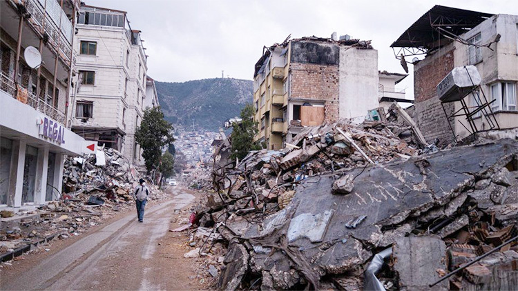
Disasters do not destroy nations; the refusal to change does
-

 Sports3 days ago
Gurusinha’s Boxing Day hundred celebrated in Melbourne
-

 News6 days ago
Lankan aircrew fly daring UN Medevac in hostile conditions in Africa
-

 Sports4 days ago
Time to close the Dickwella chapter
-
 Sports7 days ago
Royal record crushing innings win against Nalanda