Features
A skit on Lessons in US History

CHRISTOPHER COLUMBUS DAY
by Vijaya Chandrasoma
I apologize for the delay in writing this essay. Christopher Columbus Day was actually celebrated in the USA on October 9. At least I got the month right, a mistake not as spectacularly earth-shattering as the one Columbus made. He had sailed from Italy in 1492, with a crew of 90 men in three ships, the Nina, Pinta and the Santa Maria. His destination was India, from where he had been ordered by Queen Isabella of Spain to bring back the spices from the Orient, in high demand by Europeans in those times.
With his pathetic navigational skills, Columbus missed the turn-off, possibly at the Canary Islands, where the wind carried him west. He ultimately made landfall on a small island in the Bahamas, which he named San Salvador. Columbus was sure he had landed in India, as he called all the inhabitants of the island “Indians”. Although, in time, he suspected that he had made a mistake.
All the islanders who greeted him on arrival spoke in a language far more mellifluous than the jarring accents of Hindi, the language of India. Like many Europeans, Columbus had a smattering of knowledge of Hindi. After all, there are few places in the world which did not boast of an Indian restaurant, even in the 15th century. In fact, the joke runs that when Neil Armstrong landed on the moon, he sensed the spicy aromas of Indian and Chinese restaurants plying their respective culinary trades in adjacent craters.
His rival explorer, Vasco da Gama, proved to be the more skillful navigator. He took the right turn and landed in India, a land rich in the treasures sought by the Europeans of more value than gold and jewels – spices.
Chris was, however, furious that he was cheated in the naming of the New World, notwithstanding the fact that he had landed in the Bahamas, which he mistook for India. Close enough, was his argument.
The Americas, both North and South, were named after Italian explorer, Amerigo Vespucci, who explored the New World in the years after Columbus’ “discovery”, on behalf of Spain and Portugal. A whole continent named after Vespucci, by an affectionate variation of his first name used by his mamma, America.
Poor Columbus only has Columbus, a little town in Ohio, the Columbia River, Columbia University and the South American country of Colombia, named after him.
But four against an entire continent! That is hardly even worthy of comparison. Still, the Americas may have been named after Amerigo Vespucci, but, to Columbus’ credit, the Americans did not name a day after Vespucci. That honour belongs to Chris, thanks to the complete ignorance of Americans of the subject of Geography. They thought the Bahamas was a part of coastal America.
Old Chris was also not happy when he saw these strange island people with the skin-colour of a beautiful tan, a shade far more aesthetically pleasing than his own pasty-white. Hostility probably caused by an inferiority complex. A tanned skin has always been deemed attractive by Europeans, who rush to the beaches and the banks of rivers whenever the sun shines during their short-lived Summers, to bask and sunbathe in unashamed nudity.
Sadly, Europeans have infected this inferiority complex to ladies of Africa and South Asia. Living in the colonial past, these beautiful ladies, even today, try to change the varying and lovely shades of brown with which they have been blessed, in an attempt to change their skin-colour to resemble the anemic white of colonial Europeans. It is no surprise that the biggest selling cosmetic East of Suez, even in these modern, enlightened times, is skin-whitening cream.
This anomaly was driven home to me while I was working on a temporary basis in one of the resorts in the Maldive Islands, a paradise for deep-sea divers, snorkelers and sun worshippers. These little coral islands, numbering over 1,100, grouped in double chains of 27 atolls and covering an area of 115 square miles of the Indian Ocean, represent the “desert island” paradise, the retirement fantasy of many people living in the bleak, hostile, cold “civilizations” of the northern hemisphere.
The only method of transport between these islands was by speedboat or yacht, sailboat or barge. The sight of a boatful of white Europeans, sunbathing in glorious nudity on their decks, trying to get a brown tan on every inch of their bodies, was common. Equally and sadly common was the sight of beautiful brown-skinned ladies, covering every inch of the exposed parts of their bodies with a multitude of towels, to ward off the sunshine which would make them “darker”!
The real “discovery” of America is attributed to the landing of the Mayflower, with pilgrims and crew numbering 102 people, ordinary English men and women, which made landfall on Plymouth Rock in Plymouth Bay, Massachusetts, during the harsh winter of 1620. Only half these immigrants survived that first winter. The ship provided defense against the weather, while a settlement was under construction.
The pilgrims and the crew met with the neighbouring inhabitants of the land, the Wampanoag People of the tribe of Massachusetts, who initially greeted them with hospitality. This was one of the original tribes who had inhabited their lands for centuries past, living according to traditions of peace and compassion, conducting their lives in harmony with nature. The immigrants and the natives worked together till the harvest season of 1621, when they enjoyed a meal together, a historic event that is celebrated even today by Americans during the end of the third week in November.
Of course, members of the Wampanoag tribe and other native Americans are singularly conspicuous in their absence during these modern Thanksgiving celebrations.
Like all the marauding Europeans in those colonial times, they took advantage of the compassion and hospitality of the natives, which they perceived as weakness. They pretended to be friends of these unsuspecting innocents, and systematically murdered them all, in the most gruesome recorded genocide in human history.
And that, children, is the real story of the early origins of the mighty United States of America.
In our next class, Professor Ron DeSantis, graduate of Harvard University and Yale Law, Navy Seal, eminent historian, currently the Governor of Florida, will enlighten you on the great good fortune of West Africans, when they decided, of their own free will, to emigrate to this great country in the 17th century. Professor DeSantis will spellbind you with a lecture on the wonderful job opportunities that have opened up for these far-sighted immigrants, who were fortunate enough to participate in structured training programs designed to meet their specific needs in the cotton plantations in the South. As he most convincingly argues, “Black people benefited from being enslaved…. Some of these folks eventually parlayed, you know, being a blacksmith into doing better things later in life”. His thesis completely disproves the woke theories of other historians, probably damn communists, who wrongly claim that DeSantis misrepresents centuries of the brutal reality of slavery in the history of the nation.
DeSantis is a leading contender for the presidency of the greatest, most peace-loving country on the face of the Earth, in November 2024.
Let us pray.


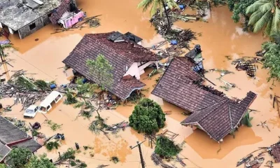
![]() On the morning of November 28, 2025, Cyclone Ditwah made an unremarkable entrance, meteorologically speaking. With winds barely scraping 75 km/h, it was classified as merely a “Cyclonic Storm” by the India Meteorological Department. No dramatic satellite spiral. No apocalyptic wind speeds. Just a modest weather system forming unusually close to the equator, south of Sri Lanka.
On the morning of November 28, 2025, Cyclone Ditwah made an unremarkable entrance, meteorologically speaking. With winds barely scraping 75 km/h, it was classified as merely a “Cyclonic Storm” by the India Meteorological Department. No dramatic satellite spiral. No apocalyptic wind speeds. Just a modest weather system forming unusually close to the equator, south of Sri Lanka.
By December’s second week, the numbers told a story of national reckoning: over 650 lives lost, 2.3 million people affected, roughly one in ten Sri Lankans, and economic losses estimated between $6-7 billion. To put that in perspective, the damage bill equals roughly 3-5% of the country’s entire GDP, exceeding the combined annual budgets for healthcare and education. It became Sri Lanka’s deadliest natural disaster since the 2004 tsunami.
The Hydrology of Horror
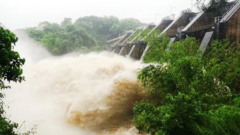
The answer lies not in wind speed but in water volume. In just 24 hours on 28 November, hydrologists estimate that approximately 13 billion cubic meters of rain fell across Sri Lanka, roughly 10% of the island’s average annual rainfall compressed into a single day. Some areas recorded over 300-400mm in that period. To visualise the scale: the discharge rate approached 150,000 cubic meters per second, comparable to the Amazon River at peak flow, but concentrated on an island 100 times smaller than the Amazon basin.
The soil, already saturated from previous monsoon rains, couldn’t absorb this deluge. Nearly everything ran off. The Kelani, Mahaweli, and Deduru Oya river systems overflowed simultaneously. Reservoirs like Kala Wewa and Rajanganaya had to release massive volumes to prevent catastrophic dam failures, which only accelerated downstream flooding.
Where Development Met Disaster
The human toll concentrated in two distinct geographies, each revealing different failures.
In the Central Highlands, Kandy, Badulla, Nuwara Eliya, Matale, landslides became the primary killer. The National Building Research Organisation documented over 1,200 landslides in the first week alone, with 60% in the hill country. These weren’t random geological events; they were the culmination of decades of environmental degradation. Colonial-era tea and rubber plantations stripped highland forests, increasing soil erosion and landslide susceptibility. Today, deforestation continues alongside unregulated hillside construction that ignores slope stability.
The communities most vulnerable? The Malaiyaha Tamil plantation workers, descendants of indentured labourers brought from South India by the British. Living in cramped “line rooms” on remote estates, they faced both the highest mortality rates and the greatest difficulty accessing rescue services. Many settlements remained cut off for days.
Meanwhile, in the Western Province urban basin, Colombo, Gampaha, Kolonnawa, the Kelani River’s overflow displaced hundreds of thousands. Kolonnawa, where approximately 70% of the area sits below sea level, became an inland sea. Urban planning failures compounded the crisis: wetlands filled in for development, drainage systems inadequate for changing rainfall patterns, and encroachments on flood retention areas all transformed what should have been manageable flooding into mass displacement.
The Economic Aftershock
By 03 December, when the cyclone had degraded to a remnant low, the physical damage inventory read like a national infrastructure audit gone catastrophic:
UNDP’s geospatial analysis revealed exposure: about 720,000 buildings, 16,000 km of roads, 278 km of rail, and 480 bridges in flooded zones. This represents infrastructure that underpins the daily functioning of 82-84% of the national economy.
The agricultural sector faces multi-season impacts. The cyclone struck during the Maha season, Sri Lanka’s major cultivation period, when approximately 563,950 hectares had just been sown. Government data confirms 108,000 hectares of rice paddies destroyed, 11,000 hectares of other field crops lost, and 6,143 hectares of vegetables wiped out. The tea industry, while less damaged than food crops, projects a 35% output decline, threatening $1.29 billion in annual export revenue.
Supply chains broke. Cold storage facilities failed. Food prices spiked in urban markets, hitting hardest the rural households that produce the food, communities where poverty rates had already doubled to 25% following the recent economic crisis.
The Hidden Costs: Externalities
Yet the most consequential damage doesn’t appear in economic loss estimates. These are what economists call externalities, costs that elude conventional accounting but compound human suffering.
Environmental externalities : Over 1,900 landslides in protected landscapes like the Knuckles Range uprooted forest canopies, buried understory vegetation, and clogged streams with debris. These biodiversity losses carry long-term ecological and hydrological costs, habitat fragmentation, compromised watershed function, and increased vulnerability to future slope failures.
Social externalities: Overcrowded shelters created conditions for disease transmission that WHO warned could trigger epidemics of water-, food-, and vector-borne illnesses. The unpaid care work, predominantly shouldered by women, in these camps represents invisible labour sustaining survival. Gender-based violence risks escalate in displacement settings yet receive minimal systematic response. For informal workers and micro-enterprises, the loss of tools, inventory, and premises imposes multi-year setbacks and debt burdens that poverty measurements will capture only later, if at all.
Governance externalities: The first week exposed critical gaps. Multilingual warning systems failed, Coordination between agencies remained siloed. Data-sharing between the Disaster Management Centre, Meteorology Department, and local authorities proved inadequate for real-time decision-making. These aren’t technical failures; they’re symptoms of institutional capacity eroded by years of budget constraints, hiring freezes, and deferred maintenance.
Why This Cyclone Was Different
Climate scientists studying Ditwah’s behaviour note concerning anomalies. It formed unusually close to the equator and maintained intensity far longer than expected after landfall. While Sri Lanka has experienced at least 16 cyclones since 2000, these were typically mild. Ditwah’s behaviour suggests something shifting in regional climate patterns.
Sri Lanka ranks high on the Global Climate Risk Index, yet 81.2% of the population lacks adaptive capacity for disasters. This isn’t a knowledge gap; it’s a resource gap. The country’s Meteorology Department lacks sufficient Doppler radars for precise forecasting. Rescue helicopters are ageing and maintenance are deferred. Urban drainage hasn’t been upgraded to handle changing rainfall patterns. Reservoir management protocols were designed for historical rainfall distributions that no longer apply.
The convergence proved deadly: a climate system behaving unpredictably met infrastructure built for a different era, governed by institutions weakened by austerity, in a landscape where unregulated development had systematically eroded natural defences.

Sources: WHO, UNICEF, UNDP, Sri Lanka Disaster Management Centre, UN OCHA, The Diplomat, Al Jazeera,
The Recovery Crossroads
With foreign reserves barely matching the reconstruction bill, Sri Lanka faces constrained choices. An IMF consideration of an additional $200 million on top of a scheduled tranche offers partial relief, but the fiscal envelope, shaped by ongoing debt restructuring and austerity commitments, forces brutal prioritisation.
The temptation will be “like-for-like” rebuilds replace what washed away with similar structures in the same locations. This would be the fastest path back to normalcy and the surest route to repeat disaster. The alternative, what disaster planners call “Build Back Better”, requires different investments:
* Targeted livelihood support for the most vulnerable: Cash grants and working capital for fisherfolk, smallholders, and women-led enterprises, coupled with temporary employment in debris clearance and ecosystem restoration projects.
* Resilient infrastructure: Enforce flood-resistant building codes, elevate power substations, create backup power routes, and use satellite monitoring for landslide-prone areas.
* Rapid disaster payments: Automatically scale up cash aid through existing social registries, with mobile transfers and safeguards for women and disabled people.
* Insurance for disasters: Create a national emergency fund triggered by rainfall and wind data, plus affordable microinsurance for fishers and farmers.
* Restore natural defences: Replant mangroves and wetlands, dredge rivers, and strictly enforce coastal building restrictions, relocating communities where necessary.
The Reckoning
The answers are uncomfortable. Decades of prioritising economic corridors over drainage systems. Colonial land-use patterns perpetuated into the present. Wetlands sacrificed for development. Budget cuts to the institutions responsible for warnings and response. Building codes are unenforced. Early warning systems are under-resourced. Marginalised communities settled in the riskiest locations with the least support.
These aren’t acts of nature; they’re choices. Cyclone Ditwah made those choices visible in 13 billion cubic meters of water with nowhere safe to flow.
As floodwaters recede and reconstruction begins, Sri Lanka stands at a crossroads. One path leads back to the fragilities that made this disaster inevitable. The other, more expensive, more complex, more uncomfortable, leads to systems designed not to withstand the last disaster but to anticipate the next ones.
In an era of warming oceans and intensifying extremes, treating Ditwah as a once-in-a-generation anomaly would be the most dangerous assumption of all.
(The writer, a senior Chartered Accountant and professional banker, is Professor at SLIIT, Malabe. The views and opinions expressed in this article are personal.)
Most reservoirs in Sri Lanka are agriculture and hydropower dominated. Reservoir operators are often unwilling to acknowledge the flood detention capability of major reservoirs during the onset of monsoons. Deviating from the traditional priority for food production and hydropower development, it is time to reorient the operational approach of major reservoir operators under extreme events, where flood control becomes a vital function. While admitting that total elimination of flood impacts is not technically feasible, the impacts can be reduced by the efficient operation of reservoirs and effective early warning systems.
At the very outset, I would like to mention that the contents in this article are based on my personal experience in the Irrigation Department (ID), and there is no intention to disrespect their contributions during the most recent flood event. The objective is to improve the efficiency and the capability of the human resources available in the ID and other relevant institutions to better respond to future flood disasters.
Reservoir operation and flood forecasting
Reservoir management is an important aspect of water management, as water storage and release are crucial for managing floods and droughts. Several numerical models and guidelines have already been introduced to the ID and MASL during numerous training programs for reservoir management and forecasting of inflows.
This article highlights expectations of engineering professionals and discusses a framework for predicting reservoir inflows from its catchment by using the measured rainfall during the previous few days. Crucially, opening the reservoir gates must be timed to match the estimated inflow.
Similarly, rainfall-runoff relationships had been demonstrated and necessary training was provided to selected engineers during the past to make a quantitative (not qualitative) forecast of river water levels at downstream locations, based on the observed rainfall in the upstream catchment.
Already available information and technology
Furthermore, this article highlights the already available technology and addresses certain misinformation provided to the mass media by some professionals during recent discussions. These discrepancies are primarily related to the opening of reservoir gates and flood forecasting.
A. Assessing the 2025 Flood Magnitude
It is not logically sound to claim that the 2025 flood in the Kelani basin was the highest flood experienced historically. While, in terms of flood damage, it was probably the worst flood experienced due to rapid urbanisation in the lower Kelani basin. We have experienced many critical and dangerous floods in the past by hydraulic definition in the Kelani Ganga.
Historical water levels recorded at the Nagalagam Street gauge illustrate this point: (See Table)

In view of the above data, the highest water level recorded at the Nagalagam river gauge during the 2025 flood was 8.5 ft. This was a major flood, but not a critical or dangerous flood by definition.
B. Adherence to Reservoir Standing Orders
According to the standing orders of the ID, water levels in major reservoirs must be kept below the Full Supply Level (FSL) during the Northeast (NE) monsoon season (from October to March) until the end of December. According to my recollection, this operational height is 1.0m below the FSL. Therefore, maintaining a reservoir below the FSL during this period is not a new practice; it explicitly serves the dual purpose of dam safety and flood detention for the downstream areas.
C. Gate Operation Methodology
When a reservoir is reaching the FSL, the daily operation of gates is expected to be managed so that the inflow of water from the catchment rainfall is equal to the outflow through the spill gates (Inflow * Outflow). The methodology for estimating both the catchment inflow and the gate outflow is based on very simple formulas, which have been previously taught to the technical officers and engineers engaged in field operations.
D. Advanced Forecasting Capabilities
Sophisticated numerical models for rainfall-runoff relationships are available and known to subject specialists of the ID through the training provided over the last 40 years. For major reservoirs, the engineers in charge of field operations could be trained to estimate daily inflows to the reservoirs, especially in cases where the simple formulas mentioned in section C are not adequate.
Design concept of reservoir flood gates
Regarding the provision of reservoir spill gates, one must be mindful of the underlying principles of probability. Major reservoir spillways are designed for very high return periods, such as 1,000 and 10,000 years. If the spillway gates are opened fully when a reservoir is at full capacity, this can produce an artificial flood of a very large magnitude. A flood of such magnitude cannot occur under natural conditions. Therefore, reservoir operators must be mindful in this regard to avoid any artificial flood creation.
In reality, reservoir spillways are often designed for the sole safety of the reservoir structure, often compromising the safety of the downstream population. This design concept was promoted by foreign funding agencies in recent times to safeguard their investment for dams. Consequently, the discharge capacities of these spill gates significantly exceed the natural carrying capacity of river downstream. This design criterion requires serious consideration by future designers and policymakers.
Undesirable gate openings
The public often asks a basic question regarding flood hazards in a river system with reservoirs: Why is flooding more prominent downstream of reservoirs compared to the period before they were built? This concern is justifiable based on the following incidents.
For instance, why do Magama in Tissamaharama face flood threats after the construction of the massive Kirindi Oya reservoir? Similarly, why does Ambalantota flood after the construction of Udawalawe Reservoir? Furthermore, why is Molkawa in the Kalutara District area getting flooded so often after the construction of Kukule reservoir?
These situations exist in several other river basins too. Engineers must therefore be mindful of the need to strictly control the operation of reservoir gates by their field staff. The actual field situation can sometimes deviate significantly from the theoretical technology discussed in air- conditioned rooms. Due to this potential discrepancy, it is necessary to examine whether gate operators are strictly adhering to the operational guidelines, as gate operation currently relies too much on the discretion of the operator at the site.
In 2003, there was severe flood damage below Kaudulla reservoir in Polonnaruwa. I was instructed to find out the reason for this flooding by the then Minister of Mahaweli & Irrigation. During my field inspection, I found that the daily rainfall in the area had not exceeded 100mm, yet the downstream flood damage was unbelievable. I was certain that 100mm of rainfall could not create a flood of that magnitude. Further examination suggested that this was not a natural flood, but was created by the excessive release of water from the radial gates of the Kaudulla reservoir. There are several other similar incidents and those are beyond the space available for this document.
Revival of Innovative systems
It may be surprising to note the high quality of real-time flood forecasts issued by the ID for the Kelani River in the late 1980s and early 1990s. This was achieved despite the lack of modern computational skills and advanced communication systems. At that time, for instance, mobile phones were non-existent. Forecasts were issued primarily via the Sri Lanka Broadcasting Corporation (SLBC )in news bulletins.
A few examples of flood warning issued during the past available in official records of the ID are given below:
Forecast issued at 6th June 1989 at 5.00 PM
“The water level at Nagalagam street river gauge was at 9 ft 0 inches at 5.0 PM. This is 1.0 ft above the major flood level. Water level is likely to rise further, but not likely to endanger the Kelani flood bund”.
Eng. NGR. De Silva, Director Irrigation
Forecast issued at 30th Oct 1991 at 6.00 PM
“The water level at Nagalagam street river gauge was at 3 ft 3 inches at 6.0 PM. The water level likely to rise further during the next 24 hours, but will not exceed 5.0 ft.”
Eng. K.Yoganathan, Director Irrigation
Forecast issued at 6th June 1993 at 10.00 AM:
“The water level at Nagalagam street river gauge was at 4 ft 6 inches last night. The water level will not go above 5.0 ft within the next 24 hours.”
Eng. K.Yoganathan, Director Irrigation
Forecast issued at 8th June 1993 at 9.00 AM:
“The water level at Nagalagam Street River gauge was at 4 ft 6 inches at 7.00 AM. The water level will remain above 4.0 ft for the next 12 hours and this level will go below 4.0 ft in the night.
The water level is not expected to rise within next 24 hours.”
Eng.WNM Boteju,Director of Irrigation
Conclusion
Had this technology been consistently and effectively adopted, we could have significantly reduced the number of deaths and mitigated the unprecedented damage to our national infrastructure. The critical question then arises: Why is this known, established flood forecasting technology, already demonstrated by Sri Lankan authorities, not being put into practice during recent disasters? I will leave the answer to this question for social scientists, administrators and politicians in Sri Lanka.
The government is rebuilding the cyclone-devastated lives, livelihoods and infrastructure in the country after the immense destruction caused by Cyclone Ditwah. President Anura Kumara Dissanayake has been providing exceptional leadership by going into the cyclone affected communities in person, to mingle directly with the people there and to offer encouragement and hope to them. A President who can be in the midst of people when they are suffering and in sorrow is a true leader. In a political culture where leaders have often been distant from the everyday hardships of ordinary people, this visible presence would have a reassuring psychological effect.
The international community appears to be comfortable with the government and has been united in giving it immediate support. Whether it be Indian and US helicopters that provided essential airlift capacity or cargo loads of relief material that have come from numerous countries, or funds raised from the people of tiny Maldives, the support has given Sri Lankans the sense of being a part of the world family. The speed and breadth of this response has contrasted sharply with the isolation Sri Lanka experienced during some of the darker moments of its recent past.
There is no better indicator of the international goodwill to Sri Lanka as in the personal donations for emergency relief that have been made by members of the diplomatic corps in Sri Lanka. Such gestures go beyond formal diplomacy and suggest a degree of personal confidence in the direction in which the country is moving. The office of the UN representative in Sri Lanka has now taken the initiative to launch a campaign for longer term support, signalling that emergency assistance can be a bridge to sustained engagement rather than a one-off intervention.
Balanced Statement
In a world that has turned increasingly to looking after narrow national interests rather than broad common interests, Sri Lanka appears to have found a way to obtain the support of all countries. It has received support from countries that are openly rivals to each other. This rare convergence reflects a perception that Sri Lanka is not seeking to play one power against another, and balancing them, but rather to rebuild itself on the basis of stability, inclusiveness and responsible governance.
An excerpt from an interview that President Dissanayake gave to the US based Newsweek magazine is worth reproducing. In just one paragraph he has summed up Sri Lankan foreign policy that can last the test of time. A question Newsweek put to the president was: “Sri Lanka sits at the crossroads of Chinese built infrastructure, Indian regional influence and US economic leverage. To what extent does Sri Lanka truly retain strategic autonomy, and how do you balance these relationships?”
The president replied: “India is Sri Lanka’s closest neighbour, separated by about 24 km of ocean. We have a civilisational connection with India. There is hardly any aspect of life in Sri Lanka that is not connected to India in some way or another. India has been the first responder whenever Sri Lanka has faced difficulty. India is also our largest trading partner, our largest source of tourism and a significant investor in Sri Lanka. China is also a close and strategic partner. We have a long historic relationship—both at the state level and at a political party level. Our trade, investment and infrastructure partnership is very strong. The United States and Sri Lanka also have deep and multifaceted ties. The US is our largest market. We also have shared democratic values and a commitment to a rules-based order. We don’t look at our relations with these important countries as balancing. Each of our relationships is important to us. We work with everyone, but always with a single purpose – a better world for Sri Lankans, in a better world for all.”
Wider Issues
The President’s articulation of foreign relations, especially the underlying theme of working with everyone for the wellbeing of all, resonates strongly in the context of the present crisis. The willingness of all major partners to assist Sri Lanka simultaneously suggests that goodwill generated through effective disaster response can translate into broader political and diplomatic space. Within the country, the government has been successful in calling for and in obtaining the support of civil society which has an ethos of filling in gaps by seeking the inclusion of marginalised groups and communities who may be left out of the mainstream of development.
Civil society organisations have historically played a crucial role in Sri Lanka during times of crisis, often reaching communities that state institutions struggle to access. Following a meeting with CSOs, at which the president requested their support and assured them of their freedom to choose, the CSOs mobilised in all flood affected parts of the country, many of them as part of a CSO Collective for Emergency Response. An important initiative was to undertake the task of ascertaining the needs of the cyclone affected people. Volunteers from a number of civil society groups fanned out throughout the country to collect the necessary information. This effort helped to ground relief efforts in real needs rather than assumptions, reducing duplication and ensuring that assistance reached those most affected.
The priority that the government is currently having to give to post-cyclone rebuilding must not distract it from giving priority attention to dealing with postwar issues. The government has the ability and value-system to resolve other national problems. Resolving issues of post disaster rebuilding in the aftermath of the cyclone have commonalities in relation to the civil war that ended in 2009. The failure of successive governments to address those issues has prompted the international community to continuously question and find fault with Sri Lanka at the UN. This history has weighed heavily on Sri Lanka’s international standing and has limited its ability to fully leverage external support.
Required Urgency
At a time when the international community is demonstrating enormous goodwill to Sri Lanka, the lessons learnt from their own experiences, and the encouraging support they are giving Sri Lanka at present, can and must be utilised. The government under President Dissanayake has committed to a non-racist Sri Lanka in which all citizens will be treated equally. The experience of other countries, such as the UK, India, Switzerland, Canada and South Africa show that problems between ethnic communities also require inter community power sharing in the form of devolution of power. Countries that have succeeded in reconciling diversity with unity have done so by embedding inclusion into governance structures rather than treating it as a temporary concession.
Sri Lanka’s present moment of international goodwill provides a rare opening to learn from these experiences with the encouragement and support of its partners, including civil society which has shown its readiness to join hands with the government in working for the people’s wellbeing. The unresolved problems of land resettlement, compensation for lost lives and homes, finding the truth about missing persons continue to weigh heavily on the minds and psyche of people in the former war zones of the north and east even as they do so for the more recent victims of the cyclone.
Unresolved grievances do not disappear with time. They resurface periodically, often in moments of political transition or social stress, undermining national cohesion. The government needs to ensure sustainable solutions not only to climate related development, but also to ethnic peace and national reconciliation. The government needs to bring together the urgency of disaster recovery with the long-postponed task of political reform as done in the Indonesian province of Aceh in the aftermath of the 2004 tsunami for which it needs bipartisan political support. Doing so could transform a national tragedy into a turning point for long lasting unity and economic take-off.
by Jehan Perera

“The future needs leaders who can adapt, learn, and respond to change without losing ethical direction” – Prime Minister

PM’s attention draws attention to the Salary Issue of the Government Translators’ Service

Hatton National Bank donates Rs. 100 Million to the ‘Rebuilding Sri Lanka’ Fund

Heavy showers above 100 mm are likely at some places in the Eastern and Central provinces and in the Badulla and Polonnaruwa districts

Post-Ditwah recovery efforts: Rs. 190 bn needed to restore roads and bridges countrywide

Siddhalepa takes authentic Lankan Ayurveda medicine to UK through a collaborative

‘Dates have the highest sugar content to fight Coronavirus’

Sunday Island 27 December – Headlines

#SundayIsland 17th December – Headlines

Sunday Island – 28th March

Sunday Island Headlines – 21 March

Sunday Island – 21st February – Headlines
-
 Business6 days ago
Cabinet approves establishment of two 50 MW wind power stations in Mullikulum, Mannar region
-
 News6 days ago
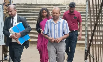
Gota ordered to give court evidence of life threats
-

 Features6 days ago
Cliff and Hank recreate golden era of ‘The Young Ones’
-
 Features6 days ago
Sri Lanka and Global Climate Emergency: Lessons of Cyclone Ditwah
-

 Latest News7 days ago
Sri Lanka squad named for ACC Men’s U19 Asia Cup
-

 Editorial6 days ago
Experience vs. Inexperience
-
 News6 days ago
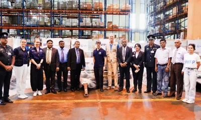
WFP scales up its emergency response in Sri Lanka
-
 News6 days ago
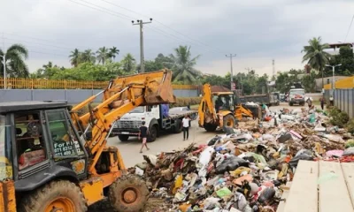
Special programme to clear debris in Biyagama