Features
A Short History of Water Polo
by Lalin Fernando
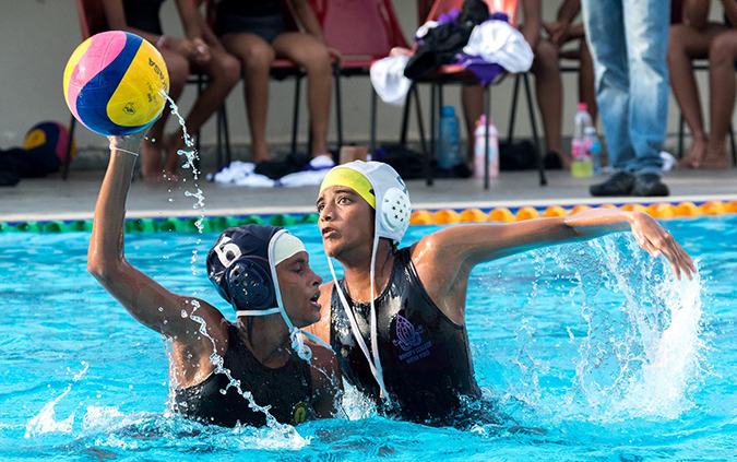
On two consecutive Saturdays of October, Royalists and Thomians, the pioneers in schools water polo, and their supporters converge on the Sugathadasa Indoor Swimming Pool for their annual Hayman Trophy Water Polo contest. This year S Thomas’ College rinsed Royal by 37 – 17, after a two year Covid break. They scored a record breaking 23- 10 and 14- 7 wins in the two games to regain the trophy. It more than made up for their defeats in 2018 and 2019.
The interest in the game has grown a lot since the two schools began playing each other. The trophy series began in 1992. There are about 12 including girls’ schools playing the game. As to be expected they are all from Colombo.
In the 1950-1960s there were three water polo leagues in the country unlike today. Westerners also took part, like at rugby. It raised challenges and playing standards among the committed. The RAF at Katunayake joined in. Otters, Kinross, Colombo Swimming Club and Old Thomians were the prominent clubs. SL teams toured India, Thailand and Malaysia then.
In SL, matches are played today in an Olympic size Indoor swimming pool built in 1991 at the Sugathadasa Stadium on land alloted by former Mayor of Colombo VA Sugathadasa. It has a 2,500 seating capacity. Earlier club and school pools were found adequate for tournaments. FINA rules allow for a length of 20 -30 m between goals (15-25 m for women and teenagers) and width of 10-20m, according to the size of the pool. The pool must be 1.8 meters deep throughout. It also had under water cameras at the inception.
Unlike in the pre 1960s there is no three foot shallow end for players to rest, especially the goalie. Players must tread water all the time they play four quarters of eight minutes each of nonstop speed swimming , attacking the opponents goal and defending theirs, a terrific demand on the players strength, fitness, speed, stamina and playing skills and a thrilling delight to both players and spectators.There are no injury or drinks breaks, DRS, TV replays to slow the action but there is VAR (Video Assistant Referee) to assist but not overturn the referee’s decision. American football coincidentally has four quarters too!
The Hayman trophy was donated in 1992 by S Thomas’ College in memory of Dr RL Hayman, Mphil, MBE (Sherborne College and Oxford) its Sub Warden (1925-1956) who donated two swimming pools to te school. The one at Mt Lavinia in 1933 was the first ever and for a very long time the only swimming pool in any school.The second at the branch school in Gurutalawa (Sri Lanka’s Gordonstoun) on 350 acres of land donated by Mr. Leslie de Saram, a cousin of Canon RS de Saram, Warden of S Thomas’. Hayman was head master at Gurutalawa during the war years and up to 1956.
Most of the buildings that came up then were paid for with his own funds. According to Canon RS de Saram, Oxford boxing blue, Dr Hayman did not care to know how much he spent on S Thomas’. They included making payments for the Thalassa (Greek for sea) building for the school office and Fives courts now converted to basketball courts.
He believed that “to spend and be spent in the service of others” was his greatest privilege. He loved the school, the people and the country that he had chosen against the concerns and advice of his parents. He thrice refused (like Caesar at Lupacal) offers by Vice Chancellor Sir Ivor Jennings who came to Gurutalawa to ask him to join the new University of Peradeniya. When he died in Bournemouth, England in 1983, Bishop Lakdasa Wickremasinghe, (Gurutalawa and Oxford) conducted the service.
Royal College started swimming in 1934 using the Thomian swimming pool and started playing water polo in 1958. When St Joseph’s opened their swimming pool in 1952 Royal shifted to the Josephian and later to the SSC pool. The Royal pool was fittingly opened by a Thomian, Prime Minister Dudley Senanayake in 1968
History of International water polo
To many spectators very little is known about water polo, let alone the rules or even the size of the pool. There are 13 nominated players of whom seven being the goalie, center forward, center back, two wing players and two will be actually treading water all the time. The numbers not surprisingly are similar to rugby sevens, American football and handball.
The game needs tactical thinking, team work and awareness. It is highly physical, demanding and difficult to play. It is probably the toughest and hardest sport in the world similar to handball (an Olympic team game since the 1936 games in Berlin and resumed in 1972) and gymnastics.
According to Dr Naresh Rao, US Olympic and water polo team physician, water polo requires aerobic (used for endurance) and anaerobic capacity (physical, mental and technical strength).An USA Olympic player says ‘to pull yourself out of the water (presumably to take a shot at goal) takes a tremendous amount of leg strength …to improve leg strength we use these weighted belts at practice’
Water polo used to be played in rivers and lakes in the mid 19th century in England. It was an aquatic version of rugby using an inflated vulcanized rubber ball from India. The word polo came from a Tibetan Balti language of Kashmir and was known as ‘Pulo’ .It was pronounced ‘Polo’ by the British troops when stationed in Cawnpore India, they played a game on horseback that had originated in Persia (Iran). Both ball and game were known as polo.
Water polo players used to plant the ball with both hands on the end of the pool like at rugby to score. Tactics were hide, dive and appear. The goalie was on the deck of the pool and jumped on the attacker. Much of it led to gang fights in the water and under water wrestling matches. It often ended with one man floating to the surface unconscious. In 1870 the London Swimming Association framed rules for indoor swimming pools.
It was introduced to USA in 1888 with the old rugby style of play adapted to American football. Flying salmon tactics had players leaping from backs of team mates to score. Violence was the main attraction. The rest of the world followed the British rules with Hungary (1889), Australia and Germany (1894), France (1895) Belgium (1900) following.
The new rules moved water polo from rugby to soccer. There was a goal cage three meteres wide and 0.9 m above the surface of the water. A player could only be tackled when one held the ball. No longer were players allowed to take the ball under water. The small rubber ball was replaced by a leather ball. It is an orange rubber ball now. Players can only use one hand to pass, collect and shoot. The goalie can use two hands.
Trudgeon Stroke
The common swimming stroke at water polo is the Trudgeon Stroke. It consists of alternating overarm strokes and a scissors kick. It was introduced to England in 1873 by a Scot player by that name. It was copied from South American Indians in Argentina. It emphasized swimming, speed and passing like at soccer. It is also called ‘combat side stroke’ and is used by the US Navy Seals as it allows them to swim more efficiently and reduce their body profile in the water.It was the first team event in the 1900 Olympics in Paris. An airtight nylon ball was then used. The matches were played in the river Seine. The champions were Osborne Swimming Club, a British club team among eight clubs from four countries that took part.
In the 1904 Olympics in St Louis USA, only US club teams played as US rules were mandated. A German team was disallowed to play .The matches were played in a pond in Forest Park under horrid conditions with players catching typhoid in an artificial contaminated pond leaving seven dead and 12 hospitalized. The US semi finals were close to a brawl.
Today FINA (International Amateur Swimming Federation) rules are followed. In 1914 USA agreed to the more civilized international rules. Europe dominated the game which was then described as a combination of swimming, football, basketball, ice hockey, rugby and wrestling! Britain’s King Charles III captained his college team at St Andrew’s University in Scotland.
The best in the world are the Hungarians who have won the most, (six) times at the Olympics and introduced the ‘dry’ pass with the Serbs and Croats closing in and Spain threatening. The Hungarian match v Russia after the 1956 invasion of their country by the Soviet army was called ‘blood on water’. The game is played all over the world today including those far apart as Brazil and China.
Visitors to the Dalmatian coast in summer could see lots of children practicing shooting at make shift goals in the sea as in beach water polo. Will SL see young people doing the same, in Kalkudah where one can wade for a hundred yards in knee deep sea water or off Casuarina Beach in the North?
With the sea all around and an abundance of lakes and rivers, water polo could become much more popular if also helped by sponsorship. Like rugby, despite physical limitations at international level, it suits the excitable temperament of the people! It costs little to play and attracts astonishing aficionados who are willing to undergo enormously punishing, strenuous and dedicated preparation in an exceptional character building game.
However sponsorship, which is vital, is sadly wanting. The excitement of the game should be the attraction and not just monetary return for captains of industry who are lured by the magic of a Royal-Thomian, Ananda-Nalandian or Joe-Pete joust that could draw immense crowds even if the game was ‘gudu’. Fortunately swimming as in all other sports is being promoted by building pools in small towns. Water polo will soon hopefully impact on Colombo from remote places, as in all other sports.

THE GREAT DIGITAL RETHINK — PART II
![]() Nordic countries handed tablets to toddlers and called it early childhood education. Now they’re taking the tablets back, handing out pencils, and hoping nobody noticed. Meanwhile, the Global South is still signing the tablet contracts. Someone should probably warn them.
Nordic countries handed tablets to toddlers and called it early childhood education. Now they’re taking the tablets back, handing out pencils, and hoping nobody noticed. Meanwhile, the Global South is still signing the tablet contracts. Someone should probably warn them.
The Tablet Arrives in Preschool
It is 2013, a government minister stands in a preschool in Stockholm, handing a shiny tablet to a four-year-old. Press cameras click. A press release announces that Sweden is building the digital classrooms of the future. The child, who until recently had been learning to hold a crayon, now swipes confidently at a screen. Innovation! Progress! The future!
Fast forward to 2023, the same Swedish government, or at least its successors, announces that preschools were wrong to make digital devices mandatory. Children’s reading comprehension is declining. Books are going back on the shelves. Pencils are making a comeback. The preschool tablets are being quietly wheeled into storage, and nobody wants to talk about the press release.
What Finland Actually Did — And Is Now Undoing
Finland has long held a special place in the global education imagination. When PISA scores are published and Finland sits at or near the top, education ministers from Seoul to São Paulo take note and wonder what they are doing wrong. Finland is the benchmark. Finland is the proof that good education is possible.
Which makes it all the more significant that Finland, in 2025, passed legislation banning mobile phones from classrooms. Not just recommending restraint. Not just issuing guidelines. Banning them, with teachers empowered to confiscate devices that disrupt learning. The law covers both primary and secondary schools. It came after years of evidence that children were distracted, and that Finland’s own PISA scores had been falling.
But the phone ban is only part of the story. The deeper shift in Finnish primary education has been a quiet reassertion of analogue fundamentals. Early literacy is being treated again as a craft that requires time, patience, practice and, crucially, a pencil.
Sweden gave tablets to toddlers. Then took them back. The pencils were in a drawer the whole time.
Sweden’s Spectacular U-Turn
Sweden’s reversal is arguably the most dramatic in recent educational history, because Sweden had gone further than most in embracing early-years digitalisation. The country had not merely allowed devices in preschool, it had in places mandated them, treating digital interaction as a developmental right alongside physical play and social learning. There was a logic to it, however misplaced: if the future is digital, surely children should encounter that future as early as possible.
The problem is that young children are not miniature adults navigating a digital workplace. They are human beings in the early stages of acquiring language, developing fine-motor-skills, building concentration and learning to regulate their own attention. These are not processes that are enhanced by a swipeable screen. Research on early childhood development is consistent on this point: young children learn language through conversation, storytelling, and physical manipulation of objects. They learn to write by writing, by the slow, muscular, tactile process of forming letters with a hand.
By 2023, Swedish education authorities had seen enough. Reading comprehension scores were down. Handwriting was deteriorating. Teachers were reporting that children were arriving in primary school unable to hold a pen properly. The policy reversed. Books came back. Cursive writing was reintroduced. The national curriculum was amended. And Sweden became, instead, a cautionary tale about what happens when you swap crayons for touchscreens before children have learned what crayons are for.
Australia: Banning Phones at Lunch
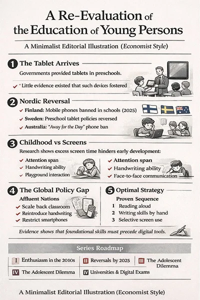 Australia’s approach to primary school digitalisation has been somewhat less ideologically charged than Scandinavia’s, and accordingly its reversal has been more pragmatic than philosophical. Australian states and territories arrived at phone bans largely through the accumulating pressure of parent complaints, teacher frustration and growing evidence that smartphones were damaging the social fabric of school life, not just in classrooms, but in playgrounds.
Queensland’s ‘away for the day’ policy, introduced in Term 1 of 2024, was notable precisely because it extended beyond lesson time to cover break times as well. This was a direct acknowledgement that the problem was not simply digital distraction during learning, it was the way that always-on connectivity was transforming childhood itself. Children who spend every break time on a phone are not playing, not resolving social conflicts face to face, not developing the unstructured social skills that primary school has always, if accidentally, taught.
The cyberbullying dimension added particular urgency in Australia, where research showed that many incidents of online harassment between primary-school children were occurring during school hours, facilitated by the phones sitting in their pockets. Banning the phone at the school gate did not solve the problem of online cruelty, but it did remove the school day as a venue for it.
The Science of the Pencil
The cognitive argument for handwriting in primary education is, it turns out, and far more interesting than the popular ‘screens bad, pencils good’ slogan suggests. The research on note-taking in university students, the finding that handwritten notes produce better conceptual understanding than typed notes, has a more fundamental parallel in primary education.
When a young child learns to write by hand, they are not merely practising a motor skill. They are encoding letters through physical movement, which activates memory systems that visual recognition alone does not reach. Studies in developmental psychology suggest that children who learn to write letters by hand recognise them faster and more accurately than those who learn through typing or tracing on screens. The hand, it appears, teaches the brain in ways the finger-swipe does not.
This does not mean that digital tools have no place in primary education, nobody sensible is arguing that children should graduate from primary school unable to use a keyboard. The question is sequencing and proportion. The emerging consensus, hard-won through a decade of failed experiments, is that foundational literacy and numeracy need to be established through analogue means before digital tools are introduced as supplements. Screens can follow pencils. Pencils, it turns out, cannot follow screens without catching up on what was missed.
The hand teaches the brain in ways the finger-swipe does not. And it took a decade of falling scores to rediscover this.
The Rest of the World Is Still Buying Tablets
Here is the uncomfortable part. While Finland legislates, Sweden reverses course and Australia bans phones from playgrounds, a large portion of the world’s primary schools are doing the opposite. Governments across South and Southeast Asia, Sub-Saharan Africa and Latin America are actively expanding device programmes in primary schools. Tablets are being distributed. Interactive whiteboards are being installed. AI tutoring apps are being piloted. The logic is identical to the logic Finland and Sweden followed 15 years ago: modernise, digitalise, equip children for the future.
The vendors selling these systems are not telling ministers about the Swedish U-turn. The development banks financing device programmes are not adjusting their models to reflect the OECD’s inverted-U curve. The international consultants advising education ministries are largely still working from a playbook written in 2010.
The lesson of the Nordic reversal is not that screens are evil, it is that screens at the wrong stage, in the wrong proportion, without the right pedagogical framework, undermine the very foundations they are supposed to build on. That lesson is available. The question is whether anyone is listening.
What Primary Schools Actually Need
Literacy and numeracy are not enhanced by early device saturation. They are built through reading aloud, through writing by hand, through mathematical reasoning with physical objects, and through the irreplaceable medium of a skilled teacher who knows their students.
Technology in primary education works best when it supplements a strong foundation, not when it substitutes for one that has not yet been built. Sweden and Finland did not fail because they used technology. They failed because they used it too extensively, and without asking what it was actually for. That question — what is this for? — is the one that every primary school system in the world should be asking before it signs another tablet contract.
SERIES ROADMAP Part I: From Ed-Tech Enthusiasm to De-Digitalisation | Part II: Phones, Pens & Early Literacy (this article) | Part III: Attention, Algorithms & Adolescents | Part IV: Universities, AI & the Handwritten Exam | Part V: A Critical Theory of Educational De-Digitalisation
(The writer, a senior Chartered Accountant and professional banker, is Professor at SLIIT, Malabe. The views and opinions expressed in this article are personal.)

Minister Bimal Rathnayake has urged all Sri Lankan refugees in India to return to Sri Lanka, stating that provision has been made for their reintegration. He called on India to grant citizenship to those who wished to stay on in India, but added that the government would welcome them back with both hands if they chose Sri Lanka. He gave due credit to the Organisation for Eelam Refugees Rehabilitation (OfERR), an NGO led by S. C. Chandrahasan, the son of S. J. V. Chelvanayakam, widely regarded as the foremost advocate of a federal solution and a historic leader of the Federal Party. OfERR has for decades assisted refugees, particularly Sri Lankan Tamils in India, with documentation, advocacy and voluntary repatriation support. Given the slow pace of resettlement of Ditwah cyclone victims, the government will need to make adequate preparations for an influx of Indian returnees for which it will need all possible assistance. The minister’s acknowledgement indicates that the government appreciates the work of NGOs when they directly assist people.
The issue of Sri Lankan refugees in India is a legacy of the three-decade long war that induced mass migration of Tamil people to foreign countries. According to widely cited estimates, the Sri Lankan Tamil diaspora today exceeds one million and is often placed between 1 and 1.5 million globally, with large communities in Canada, the United Kingdom and Australia. India, particularly Tamil Nadu, continues to host a significant refugee population. Current figures indicate that approximately 58,000 to 60,000 Sri Lankan Tamil refugees live in camps in India, with a further 30,000 to 35,000 living outside camps, bringing the total to around 90,000. These numbers have declined over time but remain one of the most visible human legacies of the conflict.
The fact that the government has chosen to make this announcement at this time indicates that it is not attempting to gloss over the human rights issues of the past that continue into the present. Those who suffered victimisation during the war may be encouraged that their concerns remain on the national agenda and have not been forgotten. Apart from those who continue to be refugees in India, there are more than 14,000 complaints of missing persons still under investigation according to the Office on Missing Persons, which has received tens of thousands of complaints since its establishment. There are also unresolved issues of land taken over by the military as high security zones, though some land has been released, and prisoners held in long term detention under the Prevention of Terrorism Act, which the government has pledged to repeal and replace.
Sequenced Response
In addressing the issue of Sri Lankan Tamil refugees in India, the government is sending a message to the Tamil people that it is not going to gloss over the past. The indications are that the government is sequencing its responses to problems arising from the past. The government faces a range of urgent challenges, some inherited from previous governments, such as war era human rights concerns, and others that have arisen more recently after it took office. The most impactful of these crises are not of its own making. Global economic instability has affected Sri Lanka significantly. The Middle East war has contributed to a shortage of essential fuels and fertilizers worldwide. Sri Lanka is particularly vulnerable to rising fuel prices. Just months prior to these global pressures, Sri Lanka faced severe climate related shocks, including being hit by a cyclone that led to floods and landslides across multiple districts and caused loss of life and extensive damage to property and livelihoods.
From the beginning of its term, the government has been compelled to prioritise economic recovery and corruption linked to the economy, which were central to its electoral mandate. As the International Monetary Fund has emphasised, Sri Lanka must continue reforms to restore macroeconomic stability, reduce debt vulnerabilities and strengthen governance. The economic problems that the government must address are urgent and affect all communities, whether in the north or south, and across Sinhalese, Tamil and Muslim populations. These problems cannot be postponed. However, issues such as dealing with the past, holding provincial council elections and reforming the constitution are not experienced as equally urgent by the majority, even though they are of deep importance to minorities. Indeed, the provincial council system was designed to address the concerns of the minorities and a solution to their problems.
Unresolved grievances tend to reappear in new forms when not addressed through political processes. Therefore, they need to be addressed sooner rather than later, even if they are not the most immediate priorities for the government. It must not be forgotten that the ethnic conflict and the three decade long war it generated was the single most destructive blow to the country, greatly diminishing its prospects for rapid economic development. Prolonged conflict reduced investment, diverted public expenditure and weakened institutions. If Sri Lanka’s early leaders had been able to negotiate peacefully and resolve their differences, the country might have fulfilled predictions that it could become the “Switzerland of the East.”
Present Opportunity
The present government has a rare opportunity to address the issues of the past in a way that ensures long term peace and justice. It has a two thirds majority in parliament, giving it the constitutional space to undertake significant reforms. It has also demonstrated a more inclusive approach to ethnic and religious minorities than many earlier governments which either mobilized ethnic nationalism for its own purposes or feared it too much to take political risks to undertake necessary reforms. Public trust in the government, as noted by international observers, remains relatively strong. During her recent visit, IMF Director General Kristalina Georgieva stated that “there is a window of opportunity for Sri Lanka,” noting that public trust in the government provides a foundation for reform.
It also appears that decades of public education on democracy, human rights and coexistence have had positive effects. This education, carried out by civil society organisations over several decades, sometimes in support of government initiatives and more often in the face of government opposition, provides a foundation for political reform aimed at justice and reconciliation. Civil society initiatives, inter-ethnic dialogue and rights-based advocacy have contributed to shaping a more informed public about controversial issues such as power-sharing, federalism and accountability for war crimes. The government would do well to expand the appreciation it has deservedly given to OfERR to other NGOs that have dedicated themselves addressing the ethnic and religious mistrust in the country and creating greater social cohesion.
The challenge for the government is to engage in reconciliation without undue delay, even as other pressures continue to grow. Sequencing is necessary, but indefinite postponement carries risks. If this opportunity for conflict resolution is not taken, it may be a long time before another presents itself. Sri Lanka may then continue to underperform economically, remaining an ethnically divided polity, not in open warfare, but constrained by unresolved tensions. The government’s recent reference to Tamil refugees in India is therefore significant. It shows that even while prioritising urgent economic and global challenges, it has not forgotten the past. Sri Lanka has a government with both the mandate and the capacity to address that past in a manner that secures a more stable and just future for all its people.
By Jehan Perera
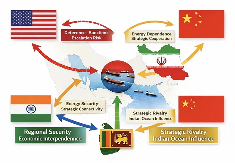
The unfolding tensions and diplomatic manoeuvres around the Strait of Hormuz offer more than a snapshot of regional instability. They reveal a deeper transformation in global statecraft, one where influence is exercised through calibrated engagement rather than outright confrontation. This is strategic diplomacy in its modern form: restrained, calculated, and layered with competing interests.
At first glance, the current developments may appear as routine diplomatic exchanges aimed at preventing escalation. However, beneath the surface lies a complex web of signalling among major and middle powers. The United States seeks to maintain deterrence without triggering an open conflict. Iran aims to resist pressure while avoiding isolation. Meanwhile, China and India, two rising powers with expanding global interests are navigating the situation with careful precision.
China’s position is anchored in economic pragmatism. As a major importer of Gulf energy, Beijing has a direct stake in ensuring that the Strait of Hormuz remains open and stable. Any disruption would reverberate through its industrial base and global supply chains. Consequently, China advocates de-escalation and diplomatic resolution. Yet, this is not purely altruistic. Stability serves China’s long-term strategic ambitions, including the protection of its Belt and Road investments and maritime routes. At the same time, Beijing remains alert to India’s growing diplomatic footprint in the region. Should India deepen its engagement with Iran and other Gulf actors, it could gradually reshape the strategic balance in areas traditionally influenced by China.
India’s approach, in contrast, reflects a confident and increasingly sophisticated foreign policy. By engaging Iran directly, while maintaining working relationships with Western powers, New Delhi is positioning itself as a credible intermediary. This is not merely about energy security, though that remains a key driver. It is also about strategic autonomy the ability to act independently in a multipolar world. India’s diplomacy signals that it is no longer a passive player but an active shaper of regional outcomes. Its engagement with Iran, particularly in the context of connectivity and trade routes, underscores its intent to secure long-term strategic access while countering potential encirclement.
Iran, for its part, views the situation through the lens of survival and strategic resilience. Years of sanctions and pressure have shaped a cautious but pragmatic diplomatic posture. Engagement with external actors, including India and China, provides Tehran with avenues to ease isolation and assert relevance. However, Iran’s trust deficit remains significant. Its diplomacy is transactional, focused on immediate gains rather than long-term alignment. The current environment offers opportunities for tactical advantage, but Iran is unlikely to make concessions that could compromise its core strategic objectives.
Even actors on the periphery, such as North Korea, are closely observing these developments. Pyongyang interprets global events through a narrow but consistent framework: regime survival through deterrence. The situation around Iran reinforces its belief that leverage, particularly military capability, is a prerequisite for meaningful negotiation. While North Korea is not directly involved, it draws lessons that may shape its own strategic calculations.
What emerges from these varied perspectives is a clear departure from traditional bloc-based geopolitics. The world is moving towards a more fluid and fragmented order, where alignments are temporary and issue-specific. States cooperate on certain matters while competing with others. This creates a dynamic but unpredictable environment, where misinterpretation and miscalculation remain constant risks.
It is within this evolving context that Sri Lanka’s strategic relevance becomes increasingly visible. The recent visit by the US Special Envoy for South and Central Asia, Sergio Gor, to the Colombo Port; is not a routine diplomatic courtesy call. It is a signal. Ports are no longer just commercial gateways; they are strategic assets embedded in global power competition. A visit of this nature underscores how Sri Lanka’s maritime infrastructure is being viewed through a geopolitical lens particularly in relation to sea lane security, logistics, and regional influence.
Such engagements reflect a broader reality: global powers are not only watching the Strait of Hormuz but are also positioning themselves along the wider Indian Ocean network that connects it. Colombo, situated along one of the busiest east–west shipping routes, becomes part of this extended strategic theatre. The presence and interest of external actors in Sri Lanka’s ports highlight an emerging pattern of influence without overt control a hallmark of modern strategic diplomacy.
For Sri Lanka, these developments are far from abstract. The island’s strategic location along major Indian Ocean shipping routes places it at the intersection of these global currents. The Strait of Hormuz is a vital artery for global energy flows, and any disruption would have immediate consequences for Sri Lanka’s economy, particularly in terms of fuel prices and supply stability.
Moreover, Sri Lanka must manage the competing interests of larger powers operating within its vicinity. India’s expanding regional role, China’s entrenched economic presence, and the growing attention from the United States all converge in the Indian Ocean. This requires a careful balancing act. Aligning too closely with any one power risks alienating others, while inaction could leave Sri Lanka vulnerable to external pressures.
The appropriate response lies in adopting a robust foreign policy that engages all major stakeholders while preserving national autonomy. This involves strengthening diplomatic channels, enhancing maritime security capabilities, and investing in strategic foresight. Sri Lanka must also recognise the growing importance of non-traditional security domains, including cyber threats and information warfare, which increasingly accompany geopolitical competition.
Equally important is the need for internal coherence. Effective diplomacy abroad must be supported by institutional strength at home. Policy consistency, professional expertise, and strategic clarity are essential if Sri Lanka is to navigate an increasingly complex international environment.
The situation in the Strait of Hormuz thus serves as both a warning and an opportunity. It highlights the fragility of global systems, but also underscores the potential for skilled diplomacy to manage tensions. For Sri Lanka, the challenge is not merely to observe these developments, but to position itself wisely within them.
In a world where power is no longer exercised solely through force, but through influence and presence, strategic diplomacy becomes not just an option, but a necessity. The nations that succeed will be those that understand this shift now and act with clarity, balance, and foresight.
Mahil Dole is a senior Sri Lankan police officer with over four decades of experience in law enforcement and intelligence. He previously served as Head of the Counter-Terrorism Division of the State Intelligence Service and has conducted extensive interviews with more than 100 suicide cadres linked to terrorist organisations. He is a graduate of the Asia-Pacific Centre for Security Studies (Hawaii).
By Mahil Dole
Senior Police Officer (Retd.), Former Head of Counter-Terrorism Division, State Intelligence Service, Sri Lanka

Esterhuizen, bowlers lead South Africa to 3-2 series win

IPL captains’ meeting: What’s on the agenda?

Russia launches 948 drones at Ukraine in largest attack over 24-hour period

Oil at $150 will trigger global recession, says boss of financial giant BlackRock

Showers will occur at several places in the Western and Sabaragamuwa provinces and in Galle and Matara districts after 2.00 pm

Senior citizens above 70 years to receive March allowances on Thursday (26)

‘Dates have the highest sugar content to fight Coronavirus’

Sunday Island 27 December – Headlines

#SundayIsland 17th December – Headlines

Sunday Island – 28th March

Sunday Island Headlines – 21 March

Sunday Island – 21st February – Headlines
-

 Features3 days ago
Trincomalee oil tank farm: An engineering marvel
-
 News7 days ago
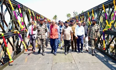
Bailey Bridge inaugurated at Chilaw
-
 News6 days ago
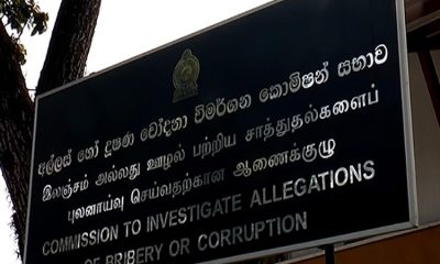
CIABOC tells court Kapila gave Rs 60 mn to MR and Rs. 20 mn to Priyankara
-

 News7 days ago
Pay hike demand: CEB workers climb down from 40 % to 15–20%
-
 Features6 days ago
Science and diplomacy in a changing world
-

 Features3 days ago
The scientist who was finally heard
-

 News5 days ago
Colombo, Oslo steps up efforts to strengthen bilateral cooperation in key environmental priority areas
-

 News3 days ago
Substandard coal deepens energy crisis, warns former CEB Chief