Weather
Showers in Western, Sabaragamuwa, Central and Northern provinces and in Galle, Matara and Trincomalee districts

Weather forecast issued at 05.30 a.m. on 18 June 2023 by the Department of Meteorology
Cloudy skies will prevail over Northern, North-Central and Eastern provinces.
Several spells of showers will occur in Western, Sabaragamuwa, Central and Northern provinces and in Galle, Matara and Trincomalee districts while a few showers will occur in North-Central and North-western provinces.
Showers or thundershowers may occur at a few places in Uva province and in Ampara and Batticaloa districts during the evening or night.
Strong winds about (40-45) kmph can be expected at times in western slopes of the central hills, North-Central province and in Puttalam, Hambantota and Trincomalee districts.
Winds will be south-westerly and speed will be (25-35) kmph. Wind speed may increase up to (50-60) kmph at times in the sea areas off the coast extending from Hambantota to Pottuvil while wind speed may increase up to (45-50) kmph at times in the sea areas off the coast extending from Trincomalee to Hambantota via Kankasanthurai, Mannar, Puttalam, Colombo, and Galle.
The sea areas off the coast extending from Hambantota to Pottuvil will be rough at times. The sea areas off the coast extending from Trincomalee to Hambantota via Kankasanthurai, Mannar, Puttalam, Colombo, and Galle will be fairly rough at times.
General public is kindly requested to take adequate precautions to minimize damages caused by temporary localized strong winds and lightning during thundershowers.


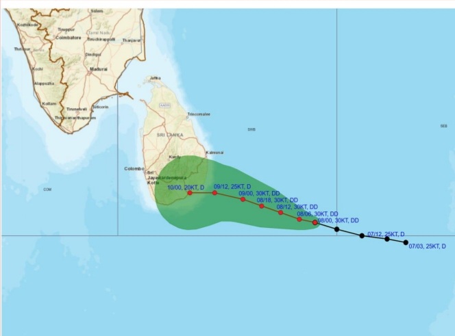
Warning for deep depression over South-east Bay of Bengal Sea area.
Issued by the Natural Hazards Early Warning Centre, Department of Meteorology at 10.30 a.m. on 08 January 2026 for the period until 10.30 a.m. 09 January 2026
The depression in the Bay of Bengal to the southeast of Sri Lanka has intensified into a deep depression and is centered near latitude 5.4°N and longitude 85.3°E, about 420 km southeast of Pottuvil at 05.30 a.m. today (08th). The above system is currently (10:00 a.m.) located about 300 km southeast of Pottuvil.
It is very likely to move west-northwestwards across the southwest Bay of Bengal and cross the Sri Lanka coast between Hambantota and Kalmunai between 5.30 p.m. to 11.30 p.m. on Friday [9th January 2026].
Hence, showery, and windy condition over the island, particularly in the Northern, NorthCentral, Eastern, Uva and Central provinces is expected to enhance from today (08th).
For the Land area:
DAMAGE EXPECTED:
• Damage to huts, temporary shelters and light structures
• Destroy the roof tops/ sheets etc.
• Damage to power and communication lines.
• Breaking of tree branches and uprooting of large avenue trees.
• Damage to paddy crops, banana, papaya trees and orchards.
• Damage to harbor yachts
• Flash flood
• Sea water inundation in low lying areas in the near coast.
Action suggested for the Land area:
• Coastal hutment dwellers are advised to move to safer places. Other people in the affected areas to remain indoors.
• People living in hilly areas (particularly landslide prone areas) and low lying areas in river basins are requested to be vigilant.
• Drivers and people using roads in the hilly areas are requested to be vigilant.
• Beware of fallen trees and power lines.
• Avoid using wired telephones and connected electric appliances during thunderstorms.
• General public is requested to be vigilant regarding impending extreme weather situation.
• For emergency assistance contact the local disaster management authorities.
• Requested to be attentive about future advisories issued by the Department of Meteorology in this regard.


Latest News
Showers above 100 mm are likely at some places in the Eastern and Uva provinces and showers about 50-75 mm in other areas

WEATHER FORECAST FOR 08 JANUARY 2026
Issued at 05.30 a.m. on 08 January 2026 by the Department of Meteorology
The depression over the Bay of Bengal, located to the southeast of Sri Lanka, was centered near latitude 5.3°N and longitude 86.0°E, about 490 km southeast of Pottuvil, at 11:30 p.m. yesterday (07). It is expected to move west-northwestwards and towards the eastern coast of the island during next 24 hours. This system is likely to intensify further into a deep depression during the next 12 hours.
Cloudy skies can be expected over most parts of the island.
Showers or thundershowers will occur at times in the Northern, North-central, Eastern, Uva, Central and Southern provinces. Showers or thundershowers may occur at several places elsewhere in the Island after 1.00 p.m. Heavy showers above 100 mm are likely at some places in the Eastern and Uva provinces. Fairly Heavy showers about (50 – 75) mm are likely at some places in the other areas of the island.
Strong winds about (50-60) kmph can be expected at times over the Eastern slopes of the central hills, the Northern, North-central, North-western and Eastern provinces and in Hambantota, Gampaha, Colombo and Monaragala districts.
The general public is kindly requested to take adequate precautions to minimize damages caused by temporary localized strong winds and lightning during thundershowers.
Weather
Showers will occur at times in the Uva province and in Batticaloa, Ampara, Polonnaruwa, Matale and Hambantota districts
WEATHER FORECAST FOR 07 JANUARY 2026
Issued at 05.30 a.m. on 07 January 2026 by the Department of Meteorology
The low-pressure area in the Bay of Bengal, to the southeast of the Sri Lanka is likely to intensify into a depression during next 12 hours. This system is expected to move west-orthwestwards,
towards the east coast of the island. Hence, showery condition over the island, particularly in the Northern, North-Central, Eastern, Uva and Central provinces is expected to enhance from
January 8th.
Showers will occur at times in the Uva province and in Batticaloa, Ampara, Polonnaruwa, Matale and Hambantota districts. Fairly Heavy showers above 50 mm are likely at some places in these areas.
Several spells of showers will occur in the Northern province and in Anuradhapura and Trincomalee districts. Showers or thundershowers may occur at several places elsewhere in the Island after 1.00 p.m.
Strong winds about 50 kmph can be expected at times over Eastern slopes of the central hills, the Northern, North-central, North-western and Eastern provinces and in Hambantota, Gampaha, Colombo and Monaragala districts.
The general public is kindly requested to take adequate precautions to minimize damages caused by temporary localized strong winds and lightning during thundershowers.

‘Dates have the highest sugar content to fight Coronavirus’

Sunday Island 27 December – Headlines

#SundayIsland 17th December – Headlines

Sunday Island – 28th March

Sunday Island Headlines – 21 March

Sunday Island – 21st February – Headlines
-

 News3 days ago
Interception of SL fishing craft by Seychelles: Trawler owners demand international investigation
-

 News3 days ago
Broad support emerges for Faiszer’s sweeping proposals on long- delayed divorce and personal law reforms
-

 News4 days ago
Private airline crew member nabbed with contraband gold
-

 News2 days ago
Prez seeks Harsha’s help to address CC’s concerns over appointment of AG
-

 News2 days ago
Govt. exploring possibility of converting EPF benefits into private sector pensions
-

 Features3 days ago
Educational reforms under the NPP government
-

 News6 days ago
Health Minister sends letter of demand for one billion rupees in damages
-

 Features4 days ago
Pharmaceuticals, deaths, and work ethics