Weather
Showers above 50mm in Western, North-western, Southern and Sabaragamuwa provinces and in Kandy and Nuwara-Eliya districts
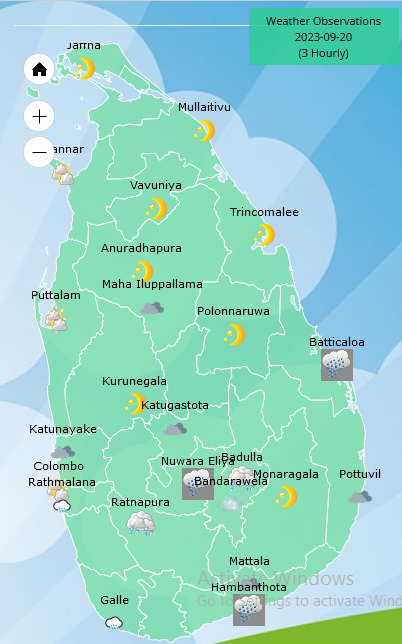
Weather forecast issued at 05.30 a.m. on 20 September 2023 by the Department of Meteorology
Showers will occur at times in Western, North-western, Southern and Sabaragamuwa provinces and in Kandy and Nuwara-Eliya districts. Fairly heavy showers above 50mm can be expected at some places. Showers or thundershowers will occur at several places in Uva and Eastern provinces during the evening or night.
Winds will be south-westerly and speed will be (25-35) kmph. Wind speed can increase up to (40-45) kmph at times in the sea areas off the coast extending from Puttalam to Kankasanthurai via Mannar and from Hambantota to Pottuvil.
The sea areas off the coast extending from Puttalam to Kankasanthurai via Mannar and from Hambantota to Pottuvil may be fairly rough at times.
General public is kindly requested to take adequate precautions to minimize damages caused by temporary localized strong winds and lightning during thundershowers.


GENERAL WEATHER FORECAST FOR NEXT 36 HOURS
Issued at 04.00 p.m. on 11 January 2026 by the Department of Meteorology
Misty conditions can be expected at some places in the Western, Sabaragamuwa and Central provinces and in Galle and Matara districts during the early hours of the morning.
Showers or thundershowers will occur at times in the Northern, North-central, Uva, Eastern and Central provinces and Hambantota district. Showers or thundershowers may occur at several places elsewhere after 1.00 pm. Fairly heavy showers above 50 mm are likely at some places in the Eastern, Uva and Sabaragamuwa provinces.
The general public is kindly requested to take adequate precautions to minimize damages caused by temporary localized strong winds and lightning during thundershowers.


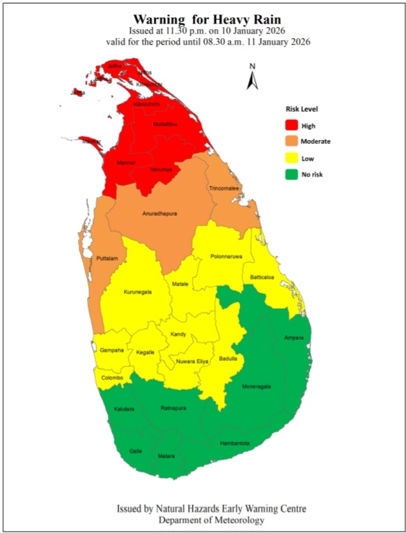
Warning for depression to the East of Sri Lanka
Issued by the Natural Hazards Early Warning Centre, Department of Meteorology
at 11.30 p.m. on 10 January 2026 for the period until 11.30 p.m. on 11 January 2026
The depression over the southwest Bay of Bengal off the northeast coast of Sri Lanka moved across the northeast coast near Mullaitivu between 3.30 and 4.30 pm today and was centred about 70 km southeast of Jaffna by 5.30 pm. It is likely to move towards the west and gradually weaken into a low-pressure area.
Cloudy skies can be expected over the Northern half of the island.
Showers or thundershowers will occur at times in the Northern province and in Puttalam, Anuradhapura and Trincomalee districts. Heavy showers above 100 mm are likely at some places in the Northern province.
DAMAGE EXPECTED: [For the Land area]
• Damage to huts, temporary shelters and light structures
• Destroy the roof tops/ sheets etc.
• Damage to power and communication lines.
• Breaking of tree branches and uprooting of large avenue trees.
• Damage to paddy crops, banana, papaya trees and orchards.
• Damage to harbor yachts
• Flash flood
• Sea water inundation in low lying areas in the near coast.
Action suggested for the Land area:
• Coastal dwellers are advised to move to safer places. Other people in the affected areas to remain indoors.
• People living in hilly areas (particularly landslide prone areas) and low-lying areas in river basins are requested to be vigilant.
• Drivers and people using roads in the hilly areas are requested to be vigilant.
• Beware of fallen trees and power lines.
• Avoid using wired telephones and connected electric appliances during thunderstorms.
• General public is requested to be vigilant regarding impending extreme weather situation.
• For emergency assistance contact the local disaster management authorities.
• Requested to be attentive about future advisories issued by the Department of Meteorology in this regard.
WEATHER FORECAST FOR 10 JANUARY 2026
Issued at 05.30 a.m. on 10 January 2026 by the Department of Meteorology
The deep depression over the southwest Bay of Bengal was located about 100 km north- northeast of Trincomalee at 4:00 a.m. on 10 January 2026. It is moving northwestwards and is
likely to weaken into a depression by around 5:30 a.m. today. It is very likely to cross the Sri Lanka coast between Trincomalee and Jaffna around noon.
Cloudy skies can be expected over the Northern half of the island.
Showers or thundershowers will occur at times in the Northern province and in Puttalam, Anuradhapura and Trincomalee districts. Heavy showers above 100 mm are likely at some places in the Northern province. Several spells of showers may occur in the Kurunegala, Polonnaruwa and Matale districts. Showers or thundershowers may occur at a few places elsewhere during evening or night.
Very strong winds about (50-60) kmph and gusting up to 70 kmph can be expected at times over the Northern province. Strong winds about (40-50) kmph can be expected at times over the North-western province and in Matale, Trincomalee and Nuwara-Eliya districts.
The general public is kindly requested to take adequate precautions to minimize damages caused by temporary localized strong winds and lightning during thundershowers

India scrape home after Kohli, Gill hit half-centuries

Bride and groom killed by gas explosion day after Pakistan wedding

Shanaka, Mendis star in 12-over run-fest to square series for Sri Lanka

One person dead and 300 buildings destroyed in Australia bushfires

Iran warns it will retaliate if US attacks as protesters defy crackdown

GENERAL WEATHER FORECAST FOR NEXT 36 HOURS

‘Dates have the highest sugar content to fight Coronavirus’

Sunday Island 27 December – Headlines

#SundayIsland 17th December – Headlines

Sunday Island – 28th March

Sunday Island Headlines – 21 March

Sunday Island – 21st February – Headlines
-

 News23 hours ago
Sajith: Ashoka Chakra replaces Dharmachakra in Buddhism textbook
-

 News6 days ago
Interception of SL fishing craft by Seychelles: Trawler owners demand international investigation
-

 Business23 hours ago
Dialog and UnionPay International Join Forces to Elevate Sri Lanka’s Digital Payment Landscape
-

 Features23 hours ago
The Paradox of Trump Power: Contested Authoritarian at Home, Uncontested Bully Abroad
-

 News6 days ago
Broad support emerges for Faiszer’s sweeping proposals on long- delayed divorce and personal law reforms
-

 Features23 hours ago
Subject:Whatever happened to (my) three million dollars?
-

 News23 hours ago
65 withdrawn cases re-filed by Govt, PM tells Parliament
-

 Opinion3 days ago
The minstrel monk and Rafiki, the old mandrill in The Lion King – II