Features
Raising of the Kotmale dam – misconceptions and facts
By Asoka Herath
BSc (Geology Hons); MSc (Engineering Geology), CEng.
Over the past few months, there has been considerable interests among not only geoscientists and engineers but also ordinary people in the potential risks faced by two of the major hydropower projects constructed in the central highlands, namely the Victoria and Kotmale projects. These projects have come into the limelight owing to some minor seismic tremors felt in the Victoria area, together with the recent announcement of the intention to raise the Kotmale dam. Alarm bells are ringing that seismic activity may jeopardize the integrity of the Victoria dam and the raising of Kotmale may result in dam failure. Should these dams fail, they will be the biggest manmade disasters our country has ever faced. This risk has prompted suggestions from the people higher up that we should seek advice from foreign experts.
Various opinions from the leading geoscientists of the country, regarding the causes and effects of this unusual activity were aired through the media recently. Some have attributed the seismic tremors to limestone quarrying in the Victoria reservoir area, some as the result of neo-tectonic movements of the central highlands, yet some others said they are reservoir-induced earthquakes. Those who are interested in the fundamentals of such activity may find the presentation in this link useful (https://www.youtube.com/watch?v=7huzvuU9TEI).
The intention of this article is to provide an insight into the geotechnical issues that influence the Kotmale Project, the risks, and to address some misconceptions people may have regarding the project. I take the liberty of writing on these issues as a person who has an in-depth knowledge of the Project by working from the site investigation phase through to construction completion, the later years as the Senior Engineering Geologist, leading the project geoscientist team.
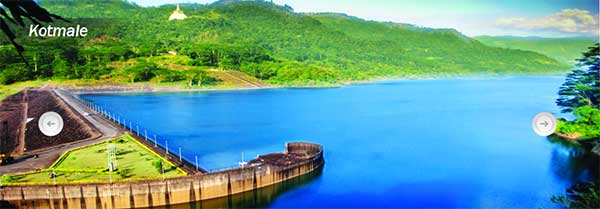
The Project
Kotmale was meant to be the main upstream storage reservoir under the Mahaweli development scheme launched in the 1960s. It will regulate the Mahaweli waters, while providing a substantial energy component. The capacity of the reservoir will be more than doubled by the proposed raising of the dam, approximately by 30 m. The project was inaugurated in 1979 and funded by Sweden. Sir William Halcrow and Partners of UK (Halcrow) with Central Engineering Consultancy Bureau of Sri Lanka (CECB) was the design engineer and Skanska of Sweden was the contractor.
 Geology of the Project Area
To understand the project risks, it is essential to understand the geology and structure of the project area. The area is underlain by Pre-Cambrian age metamorphic rocks comprising predominantly of two rock types, charnokite (gneiss) and crystalline limestone (dolomite or marble) with minor quartzites. The limestone is sandwiched between layers of charnokite gneiss.
The rock units are folded into a gentle anticlinorium (an arch like structure-convex shape) which has a slight plunge downstream. The axis of the anticline trends northwest and falls on the right abutment in the dam area. As such the dam foundation rocks have a slight inclination (15°-25°) downstream and into the abutments.
Charnokite is a very strong resistant rock, which does not breakdown easily while limestone deteriorates and erodes more easily. The initial site investigation drilling in the Kotmale valley found limestone thickness varied from 20 m to 130 m within the project area.
The limestone consists mainly of calcium carbonate (CaCO3) and partly magnesian carbonate (MgCO3). Carbonates dissolves in acidic water (acid rain) and forms solution cavities. These cavities have the potential to create leaks from the reservoirs.
Formation of the Kotmale Valley
The Kotmale valley is an amphitheatre-like valley reshaped by the erosional activity of the Kotmale Oya for millennia. It is approximately 5 km wide at the widest point, is surrounded by high rock cliffs up to 300 m high on both flanks, which converge at the Kadadora village; the site of the dam construction. The valley forming process was a combination of differential weathering and erosion of the underlying limestone unit, resulting in the collapse of overlying more resistant rock units. The basal slopes of the cliffs consist of accumulated debris of rocks and soil derived from the cliffs (termed as scree or talus). Historically these talus slopes were in perpetual slow motion (creep) towards the river. They were subjected to numerous landslides, typically during or after heavy rain events. Generally, the Kotmale valley was infamous for landslide activity.
History of Kotmale Project investigations
The location of the dam site had been selected for the seemingly favourable topography formed by the converging valley flanks. One of the first jobs assigned to me when I joined the CECB in 1978 as a young engineering geologist, was to map four exploratory tunnels driven into the abutments of the proposed dam and report the rock conditions. Our evaluation indicated the left abutment had very poor rock conditions not suitable for a dam foundation.
In 1979, to evaluate the landslide risk to the project, Halcrow carried out a landslide survey of the project area. This survey was done due to the frequent landslide activity in the Kothmale area, and its similarities to the Vajont Dam disaster that occurred in Italy in 1963, which wiped out several downstream towns resulting about 2500 deaths.
This study identified the left abutment as a settled block (subsided en mass); limestone solution the likely cause. It strongly recommended to move the damsite downstream and monitor the impressive cliffs on the left flank of the valley for potential movements.
Evaluation by a panel of experts
As these findings were major issues impacting the viability of the Project, the Mahaweli Authority of Sri Lanka as the owner of the project, in early 1980 engaged a panel of foreign experts who were the leaders in the fields of rock and soil mechanics, to evaluate the potential issues and provide recommendations. This panel endorsed the relocation of the damsite.
Subsequently, the dam axis was moved approximately 200 m downstream from the original location.
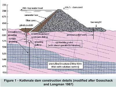
Nature and distribution of the limestone
At the new location, the limestone was at a much greater depth below the dam foundation compared to the original site as shown in Figure 1. Even so, solution cavities were observed in the contact zone and within the limestone itself identified by drilling and close circuit television (CCTV) inspections carried out in the drillholes. Our best estimate indicated small cavities, however a drillhole represents only a small area, therefore the existence of larger cavities could not be ruled out.
Leakage through cavernous limestone is widespread from the reservoirs built in our hill country. The Samanalawewa Project is the best example where significant leakage had been occurring through a cavernous limestone under the right abutment since the impoundment, which could not be sealed.
Continuity of the Kotmale limestone
Investigations were carried out to establish the continuity of the Kotmale limestone to downstream areas in view of potential leakage which were inconclusive. The recent geological map for the Kandy-Nuwara-Eliya districts (GSMB), I am convinced that the Kotmale limestone continues to Gampola-Atabage Valley and further to the Victoria Reservoir as a major rock unit. The limestone quarrying in the Victoria Reservoir area occurs in the same unit, which caused the recent furore about seismic events allegedly caused by blasting. Whilst I do not believe there is (or will be) significant leakage from Kotmale Reservoir, future raising of the dam may enhance leakage if it exists which needs evaluation.
Water tightness of the dam foundation
To eliminate the risk of water leakage through the limestone under the dam foundation, it was extensively grouted from a grouting gallery constructed below the dam level (see Figure 1). Generally, the grout intakes were low. Nevertheless, few holes required significant amounts of grout before they could be sealed. Subsequent water pressure testing indicated the limestone unit was properly sealed and the foundation was watertight.
Monitoring of the cliffs and other landslides
During the initial impoundment, the cliffs were inspected by walkover surveys and by periodic monitoring with geodetic surveying. Movements of any significance, precursor of an impending major failure were not recorded during the early years after construction.
Reservoir Induced Seismicity (RIS)
One important consideration in the construction of large reservoirs is the potential for reservoir induced seismicity (RIS). RIS is the incidence of earthquakes triggered due to the impoundment of water behind a dam. A simplistic explanation is that reservoirs trigger earth tremors due to the load of water which could activate otherwise dormant faults, the energy released causing earth tremors.
Halcrow decided to investigate the risk of movement of some major structures present in the Kotmale reservoir area upon impoundment, which could potentially induce seismic events. Consequently, a micro-seismic monitoring network (MSMN) consisting of four monitoring stations was established around Kotmale project in 1981. The monitoring program was managed by the CECB and continued until the early 90s.
Published data (Fernando & Kulasinghe 1985) show that the maximum event recorded at Kotmale during the first two and half years of monitoring, was an event of 2.25 magnitude (Richter Scale), located far away from the project area. The monitoring led to the conclusion that the potential for RIS at Kotmale was extremely low or non-existent. However, in view of the recent seismic events recorded around Victoria, it will be prudent to revisit the monitoring records from the Kotmale network, presumably archived by the CECB.
Potential risks from future raising
The Kotmale project infrastructure, were designed and constructed for future raising. Theraised dam simply achieves the original vision of the project, as the main upstream storage reservoir and increases power output.
In my opinion the geotechnical risks arising from the raising of the Kotmale dam are as follows:
= The raised water level in the reservoir will fully inundate the scree slopes and reach the base of the left bank cliffs with potential to create major landslides. Cliff monitoring should be re-established using modern methods such as satellite based synthetic aperture radar interferometry (inSAR).
= There is potential for leakage through the limestone with raised water levels. All evidence suggests the limestone under the dam was properly sealed. Leakage from the reservoir flanks cannot be prevented, which is not a fatal flaw to the project. Requirement for abutment sealing should be revisited.
= It will be useful to re-establish the monitoring program of stream gauging in the Gampola-Atabage valley to investigate if any leakage will occur from Kotmale to Atabage valley. This should be initiated before the dam raising.
= All evidence points to reservoir induced seismicity is a non-issue for Kotmale Project.
Finally, I strongly advocate the raising of the dam for the following reasons:
= The original project infrastructure was developed with the intention of future raising.
= There are potential risks but not fatal flaws to the viability of the Project. These risks can be mitigated.
= People were evacuated from their ancestral lands going under the reservoir and if the project is not completed as originally intended, then this relocation of people was without merit and a grave injustice to them.
= The country unnecessarily lost approximately 30 MW of power for more than 35 years.
The potential risks with the raising of the Kotmale dam discussed here need to be evaluated, and if the need arise, they should be mitigated and managed using local expertise. In my opinion, what Sri Lanka lacks is good project managers vital in successful implementation of projects of such enormous national importance. In hindsight, the Kotmale reservoir should have been built to the full capacity at the first instance.
(The author currently works as a Principal Geotechnical Engineer with AMC Consultants Pty Ltd, Perth, Australia, and can be contacted at hma1904@gmail.com).


Features
Illegal solar push ravages Hambantota elephant habitat: Environmentalist warns of deepening crisis
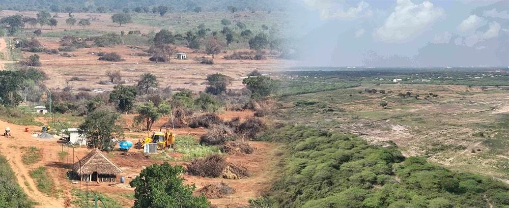
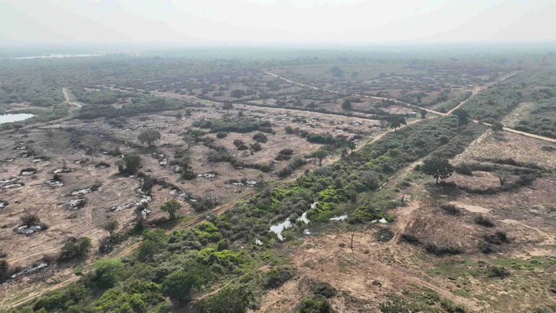
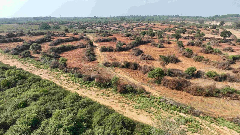
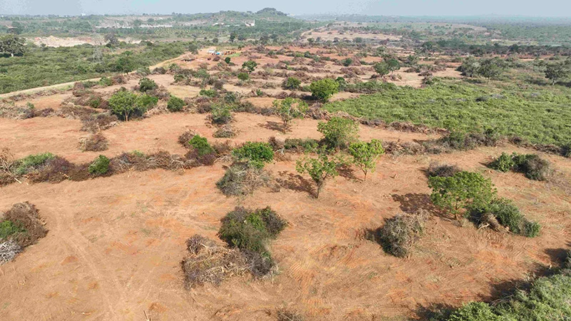
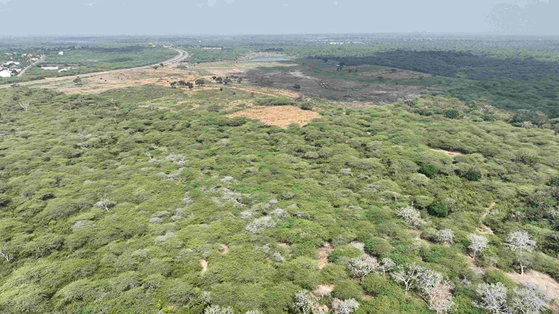
A large-scale move to establish solar power plants in Hambantota has triggered a major environmental and social crisis, with more than 1,000 acres of forest—identified as critical elephant habitat—cleared in violation of the law, environmental activist Sajeewa Chamikara said.
Chamikara, speaking on behalf of the Movement for Land and Agricultural Reform, said that 17 companies have already begun clearing forest land along the boundaries of the Hambantota Elephant Management Reserve. The affected areas include Sanakku Gala, Orukemgala and Kapapu Wewa, which are known to be key elephant habitats and long-used movement corridors.
He said that what is taking place cannot be described as development, but rather as a large-scale destruction of natural ecosystems carried out under the cover of renewable energy expansion.
According to Chamikara, the clearing of forests has been carried out using heavy machinery, while large sections have also been deliberately set on fire to prepare the land for solar installations. He said that electric fences have been erected across wide stretches of land, effectively blocking elephant movement and fragmenting their natural habitat.
“These forests are not empty lands. They are part of a living system that supports wildlife and nearby communities. Once destroyed, they cannot be easily restored,” he said.
The projects in question include a 50 megawatt solar development undertaken by five companies and a larger 150 megawatt project implemented by 12 companies. The larger project is reported to be valued at around 150 million US dollars.
Chamikara stressed that these projects are being carried out in a coordinated manner and involve extensive land clearing on a scale that raises serious environmental concerns.
He further alleged that certain companies had paid about Rs. 14 million to secure support and move ahead with the projects. He said this points to a troubling failure of oversight by state institutions that are expected to protect forests and wildlife habitats.
“This is not only an environmental issue. It is also a serious governance issue. The institutions responsible for protecting these lands have failed in their duty,” he said.
Chamikara pointed out that under the National Environmental Act, any project of this scale must receive prior approval through a proper Environmental Impact Assessment process.
He said that clearing forest land before obtaining such approval is a direct violation of the law.
He added that legal requirements relating to archaeological assessments had also been ignored. Under existing regulations, large-scale land clearing requires prior evaluation to ensure that sites of historical or cultural value are not damaged.
“The law is very clear. You cannot go ahead with projects of this nature without proper approval. What we are seeing is a complete disregard for legal procedure,” Chamikara said.
The environmental impact of these activities is already becoming visible. With their natural habitats destroyed, elephants are increasingly moving into nearby villages in search of food and shelter. This has led to a sharp rise in human-elephant conflict in several areas.
Areas such as Mayurapura, Gonnooruwa, Meegahajandura and Thanamalvila have reported increasing encounters between humans and elephants. According to Chamikara, more than 5,000 farming families in these areas are now facing growing threats to their safety and livelihoods.
He warned that farmers are being forced to abandon their lands due to repeated elephant intrusions, while incidents involving damage to crops and property are rising. There have also been increasing reports of injuries and deaths among both humans and elephants.
“This is turning into a serious social and economic problem. When farmers cannot cultivate their lands, it affects food production, income and rural stability,” he said.
Chamikara also raised concerns about the broader environmental consequences of clearing forests for solar power projects. While renewable energy is promoted as a solution to reduce carbon emissions, he said that destroying forests undermines that goal.
“Forests play a key role in absorbing carbon dioxide. When you clear and burn them, you are increasing emissions, not reducing them. That defeats the purpose of promoting solar energy,” he explained.
He added that large-scale deforestation in dry zone areas such as Hambantota could also affect local weather patterns and reduce rainfall, which would have further negative impacts on agriculture and water resources.
Chamikara called for a shift in policy, urging authorities to focus on more sustainable approaches to solar power development. He said that rooftop solar systems on homes, public buildings and commercial establishments should be given priority, as they do not require clearing large areas of land.
He also recommended that solar projects be located on degraded or abandoned lands, such as areas affected by past mining or other low-value lands, rather than forests or productive agricultural areas.
“Renewable energy development must be done in a way that does not destroy the environment. There are better options available if there is proper planning,” he said.
Chamikara urged the Central Environmental Authority and the Department of Wildlife Conservation to take immediate action to stop ongoing land clearing and investigate the projects. He stressed that all activities carried out without proper approval should be halted until legal requirements are met.
He warned that failure to act now would lead to long-term environmental damage that could not be reversed.
“If this continues, we will lose not only forests and wildlife, but also the balance between people and nature that supports rural life. The consequences will be felt for generations,” he said.
The situation in Hambantota is fast emerging as a critical test of whether development goals can be balanced with environmental protection. As pressure grows, the response of authorities in the coming weeks is likely to determine whether the damage can still be contained or whether it will continue to spread unchecked.
By Ifham Nizam

 All credit to the Tamil Nadu government for taking concrete measures to perpetuate the memory of the renowned Mahatma Gandhi of India, who on account of his moral teachings stands on par with the likes of Socrates, Plato, Aristotle, Confucius and Jalaluddin Rumi, to name a few such all-time greats. The time is indeed ripe to draw the world’s attention to the Mahatma’s humanistic legacy which has resonated in the hearts of peace-oriented sections the world over down the decades.
Under its mega developmental blueprint titled ‘ Tamil Nadu 2030’, the Tamil Nadu government, among other things, intends transforming villages into centres of economic growth in conformity with the Mahatma’s vision of making the village the fundamental unit of material and spiritual advancement. Thus will come into being the ‘Uttamar Gandhi Model Villages Project’, which will be initially covering 10 village Panchayats. (Please see page 3 of The Island of March 11, 2026).
The timeliness of remembering and appreciating anew the teachings of Mahatma Gandhi resides in the utter lawlessness that has been allowed to overtake the world over the last few decades by none other than those global powers which took it upon themselves to usher in a world political and economic order based on the UN Charter and the Universal Declaration of Human Rights. Mainly in ‘the dock’ in this regard are the permanent members of the UN Security Council.
As is plain to see, the international law and order situation has veered out of control. Principal priorities for the international community or what’s left of it is to prevent the current mainly regional war in the Middle East from degenerating dangerously into another world war, coupled with the task of eliminating the possibility of another nuclear holocaust.
The most scorching of ironies is that the world’s ‘number one power’, the US, has virtually lost its way in the ‘Global Disorder’ it has been party to letting lose. For instance, instead of making good its boast of militarily neutralizing Iran and paving the way for the constant flow of fuel and gas from the Strait of Hormus by itself and Israel, it is now appealing to the rest of the West to come to its assistance. Not surprisingly, US allies are indicating their unwillingness to help pull the US’ ‘chestnuts out of the fire’.
Oil and gas are the veritable life blood of countries and going ahead it should not come as a surprise if impatience gets the better of the major powers and the nuclear option is resorted to by some of them under the dangerous illusion that it would be a quick-fix to their growing economic ills and frustrations.
All the above and more are within the realms of the possible and the need is pressing for humanistic voices to take centre stage in the present runaway crisis. As pointed out in this column last week, Realpolitik has overtaken the world and unless the latter is convinced of the self-destructive nature of the major powers’ policy of ‘meeting fire with fire’ to resolve their disputes, annihilation could be the lot of a good part of the world.
For far too long the voice of humanity has been muted and silenced in the affairs of the world by the incendiary threats and counter-threats of the big powers and their allies. No quarter has been bold enough in these blood pressure-hiking slanging matches to speak of the need for brotherly love and compassion among nations and countries. But it’s the language of love and understanding that is the most pressing need currently and the Mahatma in his time did just that against mighty odds.
At present the US and Iran are trading threats and accusations over military-related developments in the Gulf and it’s anybody’s guess as to what turn these events will take. However, calming voices of humanity and moderation would help in deescalating tensions and such voices need to go to the assistance of the UN chief and his team.
The Mahatma used the technique of ‘Satyagraha’ or the policy of non-violent resistance to oppose and dis-empower to a degree the British empire in his time and the current major powers would do well to take a leaf from Gandhi. The latter also integrated into the strategy of non-violent resistance the policy of ‘Ahimsa’ or love and understanding which helped greatly in uniting rather than alienating adversaries. The language of love, it has been proved, speaks to the hearts and minds of people and has a profoundly healing impact.
Mahatma Gandhi defined the ideal of ‘Ahimsa’ thus: ‘In its positive form, “Ahimsa” means the largest love, the greatest charity. If I am a follower of “Ahimsa”, I must love my enemy or a stranger to me as I would my wrong-doing father or son. This active “Ahimsa” necessarily includes truth and fearlessness.’ (See; ‘Modern Indian Political Thought; Text and Context’ by Bidyut Chakrabarty and Rajendra Kumar Pandey, Sage Publications India, Pvt. Ltd., www.sagepub.in).
In the latter publication, the authors also defined the essence of ‘satyagraha’ as ‘protest without rancour’ and this is seen as ‘holding the key to his entire campaign’ of non-violent resistance. From these perspectives, the teaching, ‘hatred begets hatred’ acquires more salience and meaning.
Accordingly, the voice of reason and love needs to come centre stage and take charge of current international political discourse. The UN and allied organizations which advocate conflict resolution by peaceful means need to get together and ensure that their voices are clearly heard and understood. The global South could help in this process by seeing to the vibrant rejuvenation of organizations such as the Non-aligned Movement.
An immediate task for the peace-oriented and well meaning is to make the above projects happen fast. In the process they should underscore afresh the profound importance of the teachings of Mahatma Gandhi, who is acclaimed the world over as a uniting and healing political personality and prophet of peace.
If the Mahatma is universally acclaimed, the reason is plain to see. Put simply, he spoke to the hearts and minds of people everywhere, regardless of man-made barriers. The language of peace and brotherhood, that is, is understood by everyone. The world needs more prophets of peace and reconciliation of the likes of the Mahatma to drown out the voices of discord and war-mongering and ensure that the language of humanity prevails.

 The Future Model Hunt extravaganza, organised by Rukmal Senanayake, and advocacy trainer Tharaka Gurukanda, held in late January 2026, has brought into the limelight four outstanding contestants who will participate, at the international level, this year – Sandeepa Sewmini, Demitha Jayawardhana, Diwyanjana Senevirathna, and Nimesha Premachandra.
Nimesha took the honours as Mrs. Tourism Sri Lanka 2026 and was featured in The Island of 05th March,
Sandeepa Sewmini was crowned Miss Supranational 2026 and will represent Sri Lanka at the big event to be held in Poland later in the year.
A Business Management and Human Resources student, she will be competing under the guidance of Rukmal Senanayake from the Model With Ruki – Model Academy & Agency.
The Mister Supranational Sri Lanka crown went to Demitha Jayawardhana, a 20-year-old professional model and motocross rider.
Apart from modelling he is engaged in his family business.

Demitha Jayawardhana: Mister Supranational Sri Lanka 2026
Demitha is also a badminton player with a strong passion for sports, fitness and personal growth.
In fact, he is recognised for his strength, discipline, and passion for fitness.
A past student of Wycherley International School and St Peter’s College, Colombo, Demitha is currently in his second year of Economics Management at the Royal Institute of Colombo.
He will represent Sri Lanka at the 10th edition of the Mister Supranational pageant, in Poland, in August, 2026.
Mister and Miss Supranational are annual international beauty pageants, held in Poland, and are designed to discover new talent for the modelling and television industries and produce instant celebrities.
The competition focuses on elegance, intelligence, and social advocacy, with contestants, representing their countries.
The newly appointed Miss Teen International Sri Lanka 2026 is Diwyanjana Senevirathna.
She was crowned at the Future Model Hunt and will represent Sri Lanka at the Miss Teen International 2026 pageant in India.
Diwyanjana is noted for her grace and dedication to representing the country at this prestigious event that aims to celebrate talent, intelligence, charm, and individuality, and provide a platform for young girls to showcase their skills.

King Charles praises ‘living bridge’ with Nigeria at glitzy banquet

Our objective is to ensure that the Commission to Investigate Allegations of Bribery or Corruption operates as an independent institution, free from any external influence – PM

Showers above 50 mm can be expected at some places in the Central, Sabaragamuwa and Uva provinces and in Ampara district.

Oil nears $110 a barrel after gas field strike

Iran’s intelligence minister Esmail Khatib killed in air strike

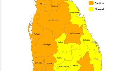
Heat Index at ‘Caution Level’ in the Western, Sabaragamuwa, North-central, Southern and North-western provinces and in Monaragala, Mannar, Vavuniya and Mullaitivu districts

‘Dates have the highest sugar content to fight Coronavirus’

Sunday Island 27 December – Headlines

#SundayIsland 17th December – Headlines

Sunday Island – 28th March

Sunday Island Headlines – 21 March

Sunday Island – 21st February – Headlines
-

 Business4 days ago
Browns EV launches fast-charging BAW E7 Pro at Rs. 5.8 million
-

 Life style5 days ago
From culture to empowerment: Indonesia’s vision for Sri Lanka
-

 News2 days ago
CIABOC questions Ex-President GR on house for CJ’s maid
-

 Opinion7 days ago
M. D. Banda: Memories of Appachchi – II
-

 Business6 days ago
Sri Lanka Institute of Information Technology raises the bar for academic excellence
-

 Latest News5 days ago
QR code system will be implemented for fuel with effect from 06.00 a.m. today (15th)
-

 News3 days ago
Australian HC debunks misleading travel risk claims for Sri Lanka
-

 Life style5 days ago
Ranjith Fernando celebrates cricketing journey with Hob Nails to Spikes