Features
Province-based Devolution in Sri Lanka: a Critique

by G H Peiris
Continued from Wednesday 16
Those provincial boundaries have remained almost unchanged during the
past 131 years, in disregard of ecological, demographic, economic and political transformations. What prevails now is an archaic and outmoded design that catered to different needs and bureaucratic circumstances.
The provincial administrative system had
only nominal contact and control over many functions of government. Those that were under the direct control of the government such as administration of justice, security, health services, road construction, land development, major hydraulic systems, postal and telecommunication services, railways, etc., were centrally controlled and invariably had sub-national spatial networks of their own.
In addition, and more significantly than all else, throughout British rule there was no irredentist threat from the Indian Sub-Continent which was largely under British rule. Nor did ‘Ceylon’ face serious external threats of destabilisation or conquest except, briefly (in 1942), during the Second World War.
Accordingly, an attempt to conduct Provincial Council elections without changing the existing configuration of provinces is tantamount to disregarding the fact that the continued existence of the present network of provinces, while not achieving effective empowerment of the under-represented and impoverished segments of our population, perpetuates the irredentist threat to the sovereignty and territorial integrity of Sri Lanka. It also ignores the ‘never again’ mandate offered by the people to the present government at the Parliamentary elections conducted last August for a major constitutional overhaul involving, inter alia, province-based devolution.
When the Dutch possessions in Sri Lanka, transferred to the British in 1796, were granted the status of a Crown Colony in 1801, the existing system of regional administration that had consisted of three ‘Collectorates’ was replaced with a network of thirteen ‘Provinces’, each centred on the coastal town after which it was named.
That arrangement, along with a separate administration over the ‘Kandyan Provinces’ annexed by the British in 1815, lasted with some modification until the Colebrooke-Cameron Reforms of 1833 when a unified system of administration embracing the entire country was established. These reforms entailed, inter alia, the setting up of a hierarchically arranged system of regional administration in which five ‘Provinces’, each under the authority of a Government Agent, constituted the basic spatial frame. The Provinces were subdivided into Districts, each comprising several Headman’s Divisions. In many instances, the Headman’s Divisions had some correspondence to the pre-British administrative units of the Portuguese and the Dutch in the lowlands and of the Kandyan kingdom in the highlands.
Yet, in demarcating the Provinces and the Districts, hardly any attempt was made either to draw from history or to accommodate the geographical realities pertaining to criteria such as access to physical resources, resource management, composition of the population, and the interdependence of the different parts of the country from the viewpoint of their development prospects. In practical terms, the main rationalisation of the provincial demarcation appears to have been that of using the best fortified coastal urban centres left behind by the Dutch (Colombo, Galle, Jaffna and Batticaloa), and the capital of the former Kandyan kingdom as bases for developing a system of control over territory, most of which was yet to be explored.
Indeed, it almost seems as if, in establishing a uniform administrative system over the entire country, and in dividing the country into Provinces and Districts, the British made a conscious attempt to move away from tradition as a means of consolidating their hold over the country.
The most pronounced feature of the provincial framework instituted through the reforms of 1833 was the annexation of the outlying territories of the former Kandyan kingdom to the coastal provinces. For instance, while Nuwarakalāviya was included in the Northern Province, Tamankaduwa and a large portion of Uva were placed within the Eastern Province. Likewise, while the Western Province was made to extend well into the Kandyan territories of the western flanks of the Central Highlands, parts of Sabaragamuwa and Uva were incorporated into the Southern Province. It has been asserted (Mills, 1964:68; de Silva, 1981:261-2; Kodikara, 1991:4-5) that the new arrangement amounted to a dismemberment of the former Kandyan kingdom, and was intended, in the words of Mills, “… to weaken the national feelings of the Kandyans”.
British administrative Demarcations of 1833
Superimposed on John Davy’s 1821 demarcation of the Kandyan Kingdom
NOTE: This illustration confirms the submissions by Mr. Samanthe Ratwatte at the SEC meeting on 3 December 2020 on the dismembering of the Kandyan Kingdom by the British in 1833.
Over the next few decades, as population and economic activities expanded, new provinces were carved out of existing ones, bringing their total number to 9 by 1889.
The provincial administration, as indicated by the content of their ‘Annual Reports’, though nominally entrusted with a wide range of functions, was largely concerned during these times with the tasks of revenue collection, infrastructure development in the form of minor construction works, and the monitoring of living conditions among the people. The government activities directly relating to the emerging modern sector of the economy, the administration of justice, and the maintenance of law and order were, for the most part, orchestrated from Colombo. Thus, the creation of new provinces – North-Western Province in 1845, North-Central Province in 1873, Uva Province in 1886, and Sabaragamuwa Province in 1889 – was, in effect, not much more than a process of increasing the number of urban centres used as the principal bases of regional administration. The provinces were not intended to serve as spatial units for the devolution of government authority except in matters of routine administration; nor were they expected to acquire an ‘identity’ in a political sense. In fact, as Governor Ridgeway observed (Administration of Ceylon, 1897:52-53) almost at the end of the 19th century:
“The existing map of the island, compiled chiefly from General Fraser’s map made early in the century, contains errors so numerous and so gross as to make it useless for administrative purposes. For example, 400 miles of provincial boundaries are still un-surveyed. Only three of the larger rivers have been completely surveyed, while in the case of the largest in the island, the Mahaveli Ganga, there is a gap of over 20 miles.”
The provincial demarcation as it stood in 1889 has remained unchanged for well over 130 years. Intra-provincial administrative adjustments were made at various times bringing the total number of Districts in the country from nineteen in 1889 to twenty-five at present. Government Agents of the provinces, holding executive power over their areas of authority, coordinated a range of government activities in their respective provinces. It is important to note, however, that in certain components of governance, while the related regional demarcations did not always coincide with provincial and district boundaries, the Government Agent had either only marginal involvement or no authority at all. This was particularly evident in fields such as the administration of justice, maintenance of law and order, and the provision of services in education and health care, in which there is large-scale daily interaction between the government and the people.
Post-Colonial Territorial Divisions
In the early years of independence, with the passing of the Administrative Districts Act No. 22 of 1955, the province lost whatever importance it had up to that time as a unit of regional administration. Since then, until 1987, the district served as the main unit of regional administration, acquiring, with the increasing politicisation of bureaucratic activities in the country, some recognition as a spatial entity to which the powers and functions of the central government could be decentralised (de Silva, 1993:109-116). A series of reforms implemented since 1973 –the setting up of District Political Authorities, post of District Ministers, District Development Councils, and District Planning Units– not only had the effect of institutionalising the process of increasing political control over the administrative machinery, but also enlarged the range of decision-making functions performed at the level of the district.
From perspective of the SEC, changes that were introduced under the so-called ‘Thirteenth Amendment to the Constitution’ and the Provincial Councils Act of 1987 could be seen, not merely as a revitalisation of the concept of the province as a unit of administration to which certain routine functions of the central government are decentralised, but as an attempt to grant political recognition and distinctiveness to the province as a unit of territorial control, and thus make the spatial framework of provinces the unit of devolution of government power from the Centre to the Regions. This latter, as the observations made above indicate, is a feature which the provincial network left behind by the British never possessed and was, in fact, never intended to possess.
The legislation to establish a system of Provincial Councils, drafted in the course of negotiations that led to the ‘Indo-Lanka Accord’ (a.k.a. Rajiv-JR Pact’) of 1987, was passed by parliament in November that year amidst fierce opposition from both the Sri Lanka Freedom Party (SLFP), the main party in the parliamentary opposition, as well as the Janatha Vimukthi Peramuna (JVP/People’s Liberation Front) which was engaged in an anti-government insurrection at that time. It provided for the transfer (subject to overall control of the central government) of a fairly wide range of powers and functions to councils elected at the level of the provinces. The powers vested by the Act on the president of the country vis-à-vis the Provincial Councils included that of appointing the ‘Provincial Governors’ and, more importantly from the viewpoint of the present discussion, the discretion of permitting the merger of provinces on a permanent or temporary basis to constitute an area of authority of a single council. The power to dissolve a provincial council was also vested in the president.
The clauses of the Provincial Councils Act pertaining to the merger of provinces were exercised by the president in September 1988 to bring about a merger of the Northern and Eastern provinces. This was a response to what had become an unequivocal demand of the Sri Lankan Tamils. The merger decision was intended to be temporary, pending the verdict of the inhabitants of the areas concerned at a referendum on whether it should be made permanent. Though the ‘North-East Provincial Council’, elected to office two months later, survived only until the final stages of withdrawal of the Indian Peace-Keeping Force from Sri Lanka. On the basis of a Supreme Court decision in 2006 which held that the temporary merger of the Northern and Eastern Provinces was no longer valid in law, the two provinces were demerged for the continuing operation of the Provincial Councils Act of 1987.
* * *
The antecedents of the PC system sketched above constitute only two sets of reasons that justify the appeal for its abolition. There are others, the most important among which are the blatant malpractice, extravagance and waste which it has involved all along. As one of our most venerated monks (a staunch source of support and constructive criticism of the ‘regime’) asked last night (13 December) in the course of his comments on the contemplated staging of PC elections, why is it, with all the power you already have, necessary to create more positions of privilege to your henchmen? As reported by the ex-Commissioner of Elections, the last parliamentary elections cost the government a staggering 15 billion rupees.
Burdened, as we are, with the necessity for pandemic precautions, island-wide PC elections will probably cost even more. With that level of expenditure, surely we can achieve a great deal of empowerment of those in dire poverty.

Minister Bimal Rathnayake has urged all Sri Lankan refugees in India to return to Sri Lanka, stating that provision has been made for their reintegration. He called on India to grant citizenship to those who wished to stay on in India, but added that the government would welcome them back with both hands if they chose Sri Lanka. He gave due credit to the Organisation for Eelam Refugees Rehabilitation (OfERR), an NGO led by S. C. Chandrahasan, the son of S. J. V. Chelvanayakam, widely regarded as the foremost advocate of a federal solution and a historic leader of the Federal Party. OfERR has for decades assisted refugees, particularly Sri Lankan Tamils in India, with documentation, advocacy and voluntary repatriation support. Given the slow pace of resettlement of Ditwah cyclone victims, the government will need to make adequate preparations for an influx of Indian returnees for which it will need all possible assistance. The minister’s acknowledgement indicates that the government appreciates the work of NGOs when they directly assist people.
The issue of Sri Lankan refugees in India is a legacy of the three-decade long war that induced mass migration of Tamil people to foreign countries. According to widely cited estimates, the Sri Lankan Tamil diaspora today exceeds one million and is often placed between 1 and 1.5 million globally, with large communities in Canada, the United Kingdom and Australia. India, particularly Tamil Nadu, continues to host a significant refugee population. Current figures indicate that approximately 58,000 to 60,000 Sri Lankan Tamil refugees live in camps in India, with a further 30,000 to 35,000 living outside camps, bringing the total to around 90,000. These numbers have declined over time but remain one of the most visible human legacies of the conflict.
The fact that the government has chosen to make this announcement at this time indicates that it is not attempting to gloss over the human rights issues of the past that continue into the present. Those who suffered victimisation during the war may be encouraged that their concerns remain on the national agenda and have not been forgotten. Apart from those who continue to be refugees in India, there are more than 14,000 complaints of missing persons still under investigation according to the Office on Missing Persons, which has received tens of thousands of complaints since its establishment. There are also unresolved issues of land taken over by the military as high security zones, though some land has been released, and prisoners held in long term detention under the Prevention of Terrorism Act, which the government has pledged to repeal and replace.
Sequenced Response
In addressing the issue of Sri Lankan Tamil refugees in India, the government is sending a message to the Tamil people that it is not going to gloss over the past. The indications are that the government is sequencing its responses to problems arising from the past. The government faces a range of urgent challenges, some inherited from previous governments, such as war era human rights concerns, and others that have arisen more recently after it took office. The most impactful of these crises are not of its own making. Global economic instability has affected Sri Lanka significantly. The Middle East war has contributed to a shortage of essential fuels and fertilizers worldwide. Sri Lanka is particularly vulnerable to rising fuel prices. Just months prior to these global pressures, Sri Lanka faced severe climate related shocks, including being hit by a cyclone that led to floods and landslides across multiple districts and caused loss of life and extensive damage to property and livelihoods.
From the beginning of its term, the government has been compelled to prioritise economic recovery and corruption linked to the economy, which were central to its electoral mandate. As the International Monetary Fund has emphasised, Sri Lanka must continue reforms to restore macroeconomic stability, reduce debt vulnerabilities and strengthen governance. The economic problems that the government must address are urgent and affect all communities, whether in the north or south, and across Sinhalese, Tamil and Muslim populations. These problems cannot be postponed. However, issues such as dealing with the past, holding provincial council elections and reforming the constitution are not experienced as equally urgent by the majority, even though they are of deep importance to minorities. Indeed, the provincial council system was designed to address the concerns of the minorities and a solution to their problems.
Unresolved grievances tend to reappear in new forms when not addressed through political processes. Therefore, they need to be addressed sooner rather than later, even if they are not the most immediate priorities for the government. It must not be forgotten that the ethnic conflict and the three decade long war it generated was the single most destructive blow to the country, greatly diminishing its prospects for rapid economic development. Prolonged conflict reduced investment, diverted public expenditure and weakened institutions. If Sri Lanka’s early leaders had been able to negotiate peacefully and resolve their differences, the country might have fulfilled predictions that it could become the “Switzerland of the East.”
Present Opportunity
The present government has a rare opportunity to address the issues of the past in a way that ensures long term peace and justice. It has a two thirds majority in parliament, giving it the constitutional space to undertake significant reforms. It has also demonstrated a more inclusive approach to ethnic and religious minorities than many earlier governments which either mobilized ethnic nationalism for its own purposes or feared it too much to take political risks to undertake necessary reforms. Public trust in the government, as noted by international observers, remains relatively strong. During her recent visit, IMF Director General Kristalina Georgieva stated that “there is a window of opportunity for Sri Lanka,” noting that public trust in the government provides a foundation for reform.
It also appears that decades of public education on democracy, human rights and coexistence have had positive effects. This education, carried out by civil society organisations over several decades, sometimes in support of government initiatives and more often in the face of government opposition, provides a foundation for political reform aimed at justice and reconciliation. Civil society initiatives, inter-ethnic dialogue and rights-based advocacy have contributed to shaping a more informed public about controversial issues such as power-sharing, federalism and accountability for war crimes. The government would do well to expand the appreciation it has deservedly given to OfERR to other NGOs that have dedicated themselves addressing the ethnic and religious mistrust in the country and creating greater social cohesion.
The challenge for the government is to engage in reconciliation without undue delay, even as other pressures continue to grow. Sequencing is necessary, but indefinite postponement carries risks. If this opportunity for conflict resolution is not taken, it may be a long time before another presents itself. Sri Lanka may then continue to underperform economically, remaining an ethnically divided polity, not in open warfare, but constrained by unresolved tensions. The government’s recent reference to Tamil refugees in India is therefore significant. It shows that even while prioritising urgent economic and global challenges, it has not forgotten the past. Sri Lanka has a government with both the mandate and the capacity to address that past in a manner that secures a more stable and just future for all its people.
By Jehan Perera
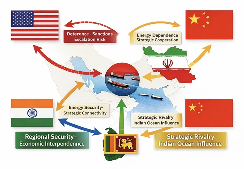
The unfolding tensions and diplomatic manoeuvres around the Strait of Hormuz offer more than a snapshot of regional instability. They reveal a deeper transformation in global statecraft, one where influence is exercised through calibrated engagement rather than outright confrontation. This is strategic diplomacy in its modern form: restrained, calculated, and layered with competing interests.
At first glance, the current developments may appear as routine diplomatic exchanges aimed at preventing escalation. However, beneath the surface lies a complex web of signalling among major and middle powers. The United States seeks to maintain deterrence without triggering an open conflict. Iran aims to resist pressure while avoiding isolation. Meanwhile, China and India, two rising powers with expanding global interests are navigating the situation with careful precision.
China’s position is anchored in economic pragmatism. As a major importer of Gulf energy, Beijing has a direct stake in ensuring that the Strait of Hormuz remains open and stable. Any disruption would reverberate through its industrial base and global supply chains. Consequently, China advocates de-escalation and diplomatic resolution. Yet, this is not purely altruistic. Stability serves China’s long-term strategic ambitions, including the protection of its Belt and Road investments and maritime routes. At the same time, Beijing remains alert to India’s growing diplomatic footprint in the region. Should India deepen its engagement with Iran and other Gulf actors, it could gradually reshape the strategic balance in areas traditionally influenced by China.
India’s approach, in contrast, reflects a confident and increasingly sophisticated foreign policy. By engaging Iran directly, while maintaining working relationships with Western powers, New Delhi is positioning itself as a credible intermediary. This is not merely about energy security, though that remains a key driver. It is also about strategic autonomy the ability to act independently in a multipolar world. India’s diplomacy signals that it is no longer a passive player but an active shaper of regional outcomes. Its engagement with Iran, particularly in the context of connectivity and trade routes, underscores its intent to secure long-term strategic access while countering potential encirclement.
Iran, for its part, views the situation through the lens of survival and strategic resilience. Years of sanctions and pressure have shaped a cautious but pragmatic diplomatic posture. Engagement with external actors, including India and China, provides Tehran with avenues to ease isolation and assert relevance. However, Iran’s trust deficit remains significant. Its diplomacy is transactional, focused on immediate gains rather than long-term alignment. The current environment offers opportunities for tactical advantage, but Iran is unlikely to make concessions that could compromise its core strategic objectives.
Even actors on the periphery, such as North Korea, are closely observing these developments. Pyongyang interprets global events through a narrow but consistent framework: regime survival through deterrence. The situation around Iran reinforces its belief that leverage, particularly military capability, is a prerequisite for meaningful negotiation. While North Korea is not directly involved, it draws lessons that may shape its own strategic calculations.
What emerges from these varied perspectives is a clear departure from traditional bloc-based geopolitics. The world is moving towards a more fluid and fragmented order, where alignments are temporary and issue-specific. States cooperate on certain matters while competing with others. This creates a dynamic but unpredictable environment, where misinterpretation and miscalculation remain constant risks.
It is within this evolving context that Sri Lanka’s strategic relevance becomes increasingly visible. The recent visit by the US Special Envoy for South and Central Asia, Sergio Gor, to the Colombo Port; is not a routine diplomatic courtesy call. It is a signal. Ports are no longer just commercial gateways; they are strategic assets embedded in global power competition. A visit of this nature underscores how Sri Lanka’s maritime infrastructure is being viewed through a geopolitical lens particularly in relation to sea lane security, logistics, and regional influence.
Such engagements reflect a broader reality: global powers are not only watching the Strait of Hormuz but are also positioning themselves along the wider Indian Ocean network that connects it. Colombo, situated along one of the busiest east–west shipping routes, becomes part of this extended strategic theatre. The presence and interest of external actors in Sri Lanka’s ports highlight an emerging pattern of influence without overt control a hallmark of modern strategic diplomacy.
For Sri Lanka, these developments are far from abstract. The island’s strategic location along major Indian Ocean shipping routes places it at the intersection of these global currents. The Strait of Hormuz is a vital artery for global energy flows, and any disruption would have immediate consequences for Sri Lanka’s economy, particularly in terms of fuel prices and supply stability.
Moreover, Sri Lanka must manage the competing interests of larger powers operating within its vicinity. India’s expanding regional role, China’s entrenched economic presence, and the growing attention from the United States all converge in the Indian Ocean. This requires a careful balancing act. Aligning too closely with any one power risks alienating others, while inaction could leave Sri Lanka vulnerable to external pressures.
The appropriate response lies in adopting a robust foreign policy that engages all major stakeholders while preserving national autonomy. This involves strengthening diplomatic channels, enhancing maritime security capabilities, and investing in strategic foresight. Sri Lanka must also recognise the growing importance of non-traditional security domains, including cyber threats and information warfare, which increasingly accompany geopolitical competition.
Equally important is the need for internal coherence. Effective diplomacy abroad must be supported by institutional strength at home. Policy consistency, professional expertise, and strategic clarity are essential if Sri Lanka is to navigate an increasingly complex international environment.
The situation in the Strait of Hormuz thus serves as both a warning and an opportunity. It highlights the fragility of global systems, but also underscores the potential for skilled diplomacy to manage tensions. For Sri Lanka, the challenge is not merely to observe these developments, but to position itself wisely within them.
In a world where power is no longer exercised solely through force, but through influence and presence, strategic diplomacy becomes not just an option, but a necessity. The nations that succeed will be those that understand this shift now and act with clarity, balance, and foresight.
Mahil Dole is a senior Sri Lankan police officer with over four decades of experience in law enforcement and intelligence. He previously served as Head of the Counter-Terrorism Division of the State Intelligence Service and has conducted extensive interviews with more than 100 suicide cadres linked to terrorist organisations. He is a graduate of the Asia-Pacific Centre for Security Studies (Hawaii).
By Mahil Dole
Senior Police Officer (Retd.), Former Head of Counter-Terrorism Division, State Intelligence Service, Sri Lanka
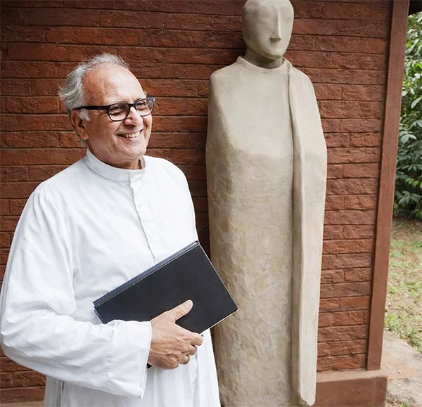
I knew that I would have to share my thoughts about the most inspiring thought leader of my life, one day. When I spoke of his virtues two years ago, at the time of him celebrating his 90th birthday with “Tulana” research centre, his coveted creation, reaching 50th year, I did not expect this day to be so soon. I am referring to the heavenly departure of Rev. Professor Aloysius Peiris, SJ, known to most as “Fr. Aloy’”.
Overview
Fr. Aloy was born on 9th April, 1934 in Ampitiya, Kandy and peacefully passed away on 22nd March, 2026 just few weeks before his 93rd birthday. Hailing from a family that has produced nuns and priests, his religious formation as a Jesuit opened pathways to reach east and west alike, as an eminent theologian, erudite scholar, and an exemplary priest.
Fr. Aloy became the first Sri Lankan Catholic Priest to obtain a Ph.D. in Buddhist Philosophy from the Vidyodaya Campus, University of Sri Lanka. It was Fr. Marceline Jayakody, OMI who became popularly known as Pansale Piyathuma (The priest of the Buddhist temple), because of his association with Buddhist culture, influencing his much-popular hymns with authentic local flavour. I would not hesitate to hail, Fr. Aloy as Pansale Piyathuma (The priest of the Buddhist monastery). It was heartening to see Buddhist monks visiting him to study pitakas and “suttas which are revered religious texts, under his valued guidance. He was awarded the prestigious Honourary Doctorate of Literature (D.Litt) by the same institution, now University of Kelaniya in 2015.
Moreover, Fr. Aloy obtained three theological degrees, an L.Ph. from Sacred Heart College in Shembaganur, India (1959), STL from the Pontifical Theological Faculty in Naples (1966), and a Th.D. from Tilburg University (1987). Fr. Aloy also has a BA in Pali and Sanskrit from the University of London (1961). As he shared with my friend Asoka Dias, during a recent interview of Sirsa TV, the proficiency in both western and eastern languages opened many doors for him to reach out to deserving communities.
It is heat-warming to recall my first encounter with Fr. Aloy as a student awaiting to start my Advanced Level classes, on his 50th birthday. He guided me how to study rhythmically maintaining the needed balance. My fruitful association with him has spanned over 42 years with enriching guidance, engaging dialogue, and entrusting commitment. I must whole-heartedly acknowledge that He was the one who pursued me to embark on an academic career, moving from the lucrative private sector as an engineer turned manager. It was a conscious shift listening to my yearning inner purpose, and Fr. Aloy was a guiding light and a glittering beacon, showing the salient way. I would simply recognize him with utmost respect, as an authentic thought leader who was an inspirer, influencer, and an initiator.
Fr Aloy as an Inspirer
Fr Aloy inspired millions around the globe through his scholarly writing. His books and articles have been translated into many languages. Among them, An Asian Theology of Liberation and Love Meets Wisdom appear prominently. He is the author of more than 30 books and well over 500 Research Papers. He was of the view that any authentic theology for Asia must grapple with both poverty and religious pluralism. He calls for a theology born from listening not only to Scripture, but also to the suffering of the poor and the wisdom of ancient traditions like Buddhism. There comes the connection to love and wisdom. Fr Aloy argued that Christianity (focused on “love” or agape) and Buddhism (focused on “wisdom” or prajna) are complementary, proposing that authentic engagement requires embracing the core strengths of both traditions to achieve spiritual maturity.
He has been the editor of Vagdevi, a journal of religious reflection, until his demise. I remember receiving a copy of the latest a few months ago, where his authentic views on contemporary Christianity, were clearly and coherently expressed. Same with the case of many of his sought-after religious writings, such as Give Vatican II a Chance, Leadership in the Church, Relishing our Faith in Working for Justice, Lent in Lanka – Reflections and Resolutions and God’s Reign for God’s Poor. I must confess that, though representing a different specialty, my writing has been immensely inspired by Fr. Aloy.
Fr. Aloy as an Influencer
He was a distinctly different thinker in terms of linking theology with poverty on one side and inter-religious dialogue on the other side. He argued that any theology for Asia must consider the realities of poverty, pluralism, and power. Religion, as he perceived, must be a force for healing and liberation and not for division and fragmentation. He was a key resource in the 1980s for the Federation of Asian Bishops’ Conferences (FABC), where he helped shape a distinctly Asian Catholic theology dialogical, incarnational, and deeply rooted in the continent’s spiritual traditions.
I recall him having numerous conversations with Rev. Fr. Oscar Abeyrathne (popularly known as Swami Thaththa, initiator of Kithudana Pubuduwa (Catholic Charismatic Renewal” in Sri Lanka). If I may observe, Fr Aloy as the “influencer,” Fr. Oscar was the “implementor.” As a youth leader of “Kithudana Pubuduwa,” I learnt how to wear the national dress with pride and how to participate in Catholic rituals with enhanced oriental flavour. When, “tyer pyres” were prevalent with burning youth, during 88-89 insurrection, we as youth were guided towards a non-violent path, yet, upholding social justice, by both of them.
Fr. Aloy as an Initiator
I remember cycling from my native home in Pamunuwila to an “oasis” overtly known worldwide yet having its humble presence amidst lush greenery. That is what Fr. Aloy initiated 52 years ago as “Tulana”. To be precise, Tulana Research Centre for Encounter and Dialogue. The word Tulana has its origin in Sanskrit, can be translated as discernment. It also symbolically means balancing, harmonis+ing, and complementing, with due reference to Christianity and Buddhism.
According to Fr. Aloy, the primary founding motivation was as a response to two challenges – the challenge of the spirituality and philosophy of Sri Lanka’s major religion, Buddhism, and the challenge of the socio-political aspirations of the highly educated but marginalised rural youth. The vast library, aptly named as Fr. S. G. Perera Memorial Oriental Library, includes mainly the book collection of the late Fr. S. G. Perera, the first Sinhalese Jesuit in Sri Lanka, who gifted his collection to Fr. Pieris so many years ago. I had the rare privilege of reading, relating, and reflecting, in this revered resource centre during my Advanced Level and university times. The collection of science fiction stories I published, were mostly written at Tulana library.
Apart from the rich knowledge base, Tulana has a rare collection of pantings, carvings and many other symbolic ways of demonstrating the eastern perspectives of Christianity. Among many, the creations by Ven. Hathigammana Uthththarananda Thero, depicting Christ in a Buddhist context, are indeed serene and significant.
I will fail in my duty if I do not mention another feat of Fr. Aloy as an initiator. It is the Centre for Education of Hearing Impaired Children (CEHIC). Located in Dalugama, Kelaniya, it is a “small miracle of hope,” for many. Since the inception in 1982, Fr. Aloy has been steadfastly supporting Rev. Sr. Greta Nalawatta, in healing thousands, and paving the path of prosperity. I remember late Prof. Carlo Fonseka saying at CEHIC, what he saw of curing the medically-declared deafness through a holistic auditory-verbal method is a “real miracle.” It gives me immense happiness to be a member of the Education Board of CEHIC, in contributing to the valued vision of Fr Aloy.
A Spiritual Sage of our Age
Many more can be written about Fr. Aloy, as a salient spiritual sage of our age. His intellectual and interactional prowess with people-friendly approach paved way for him to be a sought-after sharer. He was multi-talented in being a musician from his early age as well. He battled a key health challenge but the way he perceived, it was “joyful suffering.” He was not hesitant to call a spade a spade, despite receiving bouquets and brickbats alike. He was highly critical of “Ecclesiastics Politics,” the way he described some inner dynamics of the Church.
Fr. Aloy truly lived a life, meaningfully aligned to the aspiration of St. Ignatius Loyola, the founder of Society of Jesus, his religious order. It is to find God in all things and taking action for the greater glory of God ( Ad Maiorem Dei Gloriam). He duly responded to the question raised by the Buddha (in Yamakavagga). “However many holy words you read, however many you speak, what good will they do you if you do not act on upon them?”
Life is to love, learn, lead and to leave a legacy. Goodbye, my beloved inspirer, influencer, and initiator. May Rev. Fr. Aloysious Peiris, SJ have a blissful heavenly journey.
The writer is
Senior Professor in Management
Postgraduate Institute of Management, University of Sri Jayewardenepura
by Ajantha S. Dharmasiri

Referendum defeat leaves Italy’s Meloni looking more vulnerable

Pakistan T20 cricket league to be held in empty stadiums amid oil crisis

Showers expected in the Western, Southern, Uva and Sabaragamuwa provinces and in Kandy and Nuwara-Eliya districts after 2.00 pm.

Tehran says Trump’s peace talk claims are ‘fake news’

SJB: China, India taking advantage of Lanka’s unregulated oil market

SL to redevelop Trinco tank farm expeditiously

‘Dates have the highest sugar content to fight Coronavirus’

Sunday Island 27 December – Headlines

#SundayIsland 17th December – Headlines

Sunday Island – 28th March

Sunday Island Headlines – 21 March

Sunday Island – 21st February – Headlines
-

 News6 days ago
CIABOC questions Ex-President GR on house for CJ’s maid
-
 News5 days ago
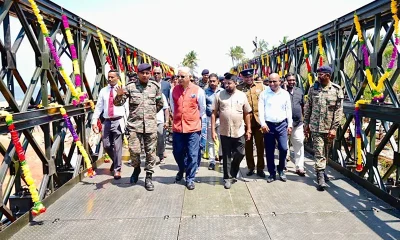
Bailey Bridge inaugurated at Chilaw
-

 Features1 day ago
Trincomalee oil tank farm: An engineering marvel
-
 News4 days ago
CIABOC tells court Kapila gave Rs 60 mn to MR and Rs. 20 mn to Priyankara
-

 News5 days ago
Pay hike demand: CEB workers climb down from 40 % to 15–20%
-

 Editorial6 days ago
Couple QR-based quota with odd-even rationing
-
 Features4 days ago
Science and diplomacy in a changing world
-

 News3 days ago
Colombo, Oslo steps up efforts to strengthen bilateral cooperation in key environmental priority areas