Weather
Very heavy showers about 150 mm are likely at some places in Sabaragamuwa province and in Kandy and Nuwara-Eliya districts.
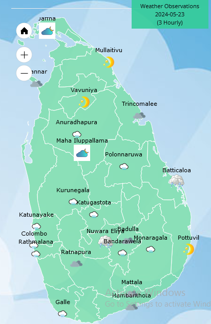
Weather forecast issued at 05.30 a.m. on 23 May 2024 by the Department of Meteorology
The Southwest monsoon conditions are gradually establishing over the island; hence, the prevailing showery and windy conditions will continue further.
Showers or thundershowers will occur at times in Western, Sabaragamuwa, Central, North-western, Southern and Northern provinces and at several places elsewhere of the island. Very heavy showers about 150 mm are likely at some places in Sabaragamuwa province and in Kandy and Nuwara-Eliya districts. Heavy showers above 100 mm are likely at some places in Western and North-western provinces and in Mannar, Galle and Matara districts.
Strong winds of about (50-60) kmph can be expected at times over Western slopes of the central hills and in Northern, North-central, Western, Southern and North western provinces. Fairly strong winds about (30-40) kmph can be expected at times elsewhere of the island.
Winds will be south-westerly in the sea areas around the island. Wind speed will be (40-50) kmph and wind speed may increase up to (60-70) kmph at times in the sea areas extending from Mannar to Pottuvil via Colombo, Galle and Hambantota. Wind speed will be (30-40) kmph and can be increased up to (50-60) kmph at times in the other sea areas around the island.
The sea areas extending from Kalpitiya to Pottuvil via Colombo, Galle and Hambantota will be very rough at times and Naval and fishing communities are advised not to venture into these sea areas, until further notice.
The sea areas extending from Mannar to Kalpitiya will be rough at times, therefore, naval and fishing communities in this sea area are requested to be vigilant in this regard.
The swell waves (about 2.5–3.0 m) height (this is not for land area) may increase in the sea areas off the coast extending from Kalpitiya to Pottuvil via Colombo, Galle, and Hambantota.
Strong gusty winds and very rough seas can be expected during thundershowers.


Weather
Showers in the Western, Sabaragamuwa and North-western provinces and in Galle, Matara, Kandy, Nuwara-Eliya, Anuradhapura and Mannar districts.

WEATHER FORECAST FOR 04 JULY 2026
Issued at 05.30 a.m. on 04 July 2026 by the Department of Meteorology
Showers will occur at times in the Western, Sabaragamuwa and North-western provinces and in Galle, Matara, Kandy and Nuwara-Eliya districts. Fairly heavy showers above 50 mm are likely at some places in these areas. Several spells of showers will occur in the Anuradhapura and Mannar districts.
Strong winds about (40-50) kmph can be expected at times over the Western slopes of the central hills, the Northern, North-central and North-western provinces and in Rathnapura, Hambantota and Trincomalee districts.
Weather
Showers will occur in the Western, Sabaragamuwa and North-western provinces and in Galle, Matara, Kandy, Nuwara-Eliya and Anuradhapura districts

WEATHER FORECAST FOR 03 JULY 2026
Issued at 05.30 a.m. on 03 July 2026 by the Department of Meteorology
Several spells of showers will occur in the Western, Sabaragamuwa and North-western provinces and in Galle, Matara, Kandy and Nuwara-Eliya districts. A few showers may occur in the Anuradhapura district.
Strong winds about (40-50) kmph can be expected at times over the Western slopes of the central hills, the Northern, North-central and North-western provinces and in Hambantota and Trincomalee districts.
Weather
A few showers will occur in the Western, Sabaragamuwa and North-western provinces and in Galle, Matara, Kandy and Nuwara-Eliya districts
WEATHER FORECAST FOR 02 JULY 2026
Issued at 05.30 a.m. on 02 July 2026 by the Department of Meteorology
A few showers will occur in the Western, Sabaragamuwa and North-western provinces and in Galle, Matara, Kandy and Nuwara-Eliya districts.
Strong winds about (40-50) kmph can be expected at times over the Western slopes of the central hills, the Northern, North-central and North-western provinces and in Hambantota and Trincomalee districts

Brutal heat cancels Fourth of July events, from DC to Philadelphia

Arias sends Colombia into World Cup last-16 with 1-0 win over Ghana

Messi scores again but Argentina given World Cup upset fright by Cape Verde

Anguished families left to identify Venezuela quake victims at makeshift morgue

Ukrainian suspect hunted by police after Monaco bomb attack was ‘disguised as a man’

Showers in the Western, Sabaragamuwa and North-western provinces and in Galle, Matara, Kandy, Nuwara-Eliya, Anuradhapura and Mannar districts.

‘Dates have the highest sugar content to fight Coronavirus’

Sunday Island 27 December – Headlines

#SundayIsland 17th December – Headlines

Sunday Island – 28th March

Sunday Island Headlines – 21 March

Sunday Island – 21st February – Headlines
-

 News5 days ago
LAWASIA warns against ad hoc initiative to increase judges’ retirement ages
-

 News4 days ago
Chamuditha to seek removal of injunction on Youtube programme
-
 Features4 days ago
Climate action to bring South Asia together
-

 News7 days ago
Another 1,132 Sri Lankan Personnel to be deployed for United Nations Peacekeeping Missions
-

 Features6 days ago
People’s Bank expands digital banking network with 125th cheque deposit kiosk
-

 News1 day ago
SLAF conducts successful rescue mission under UN command in Central African Republic
-

 News4 days ago
CPRP alleges another death in custody, seeks protection for witness
-

 News1 day ago
CIABOC to question Harak Kata on Rs. 200 mn bribery allegation