Weather
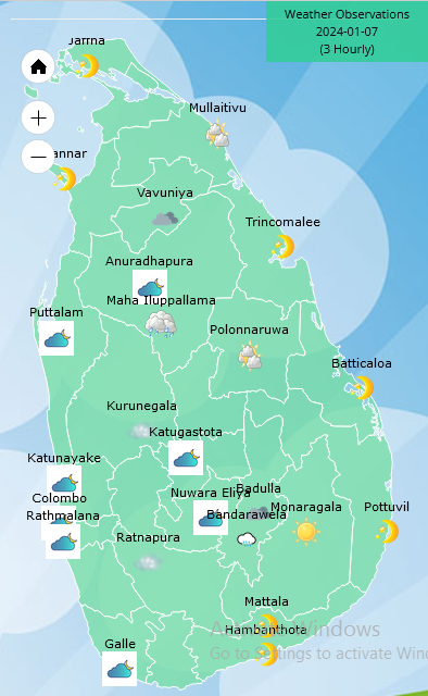
Showery weather condition expected to enhance over Northern, North-central, Eastern and Uva provinces from today (07)
Weather forecast issued at 05.30 a.m. on 07 January 2024 by the Department of Meteorology
Showery weather condition is expected to enhance over Northern, North-central, Eastern and Uva provinces from today (07).
Misty conditions can be expected at some places in Western, Sabaragamuwa and Central provinces during the morning.
Showers will occur at times in Eastern and Northern provinces. Several spells of showers will occur in North-central and Uva provinces while showers or thundershowers will occur at several places in other areas of the island after 1.00 p.m. Fairly heavy showers above 75 mm are likely at some places in Western, Sabaragamuwa Southern and Central provinces.
Winds will be easterly or north-easterly and wind speed will be (20-30) kmph. Wind speed may increase up to 40 kmph at times in the sea areas off the coasts extending from Colombo to Kankasanthurai via Puttalam and Mannar.
The sea areas off the coasts extending from Colombo to Kankasanthurai via Puttalam and Mannar can be moderate at times but strong gusty winds and very rough seas can be expected during thundershowers.
The public is kindly requested to take adequate precautions to minimize damages caused by temporary localized strong winds and lightning during thundershowers


Weather
Showers expected in the Central, North-central , Uva, Eastern, Southern and Northern provinces and in Kaluthara district
WEATHER FORECAST FOR 13 FEBRUARY 2026
Issued at 05.30 a.m. on 13 February 2026 by the Department of Meteorology
Misty conditions can be expected at some places in the Western, Sabaragamuwa and provinces and in Galle and Matara districts during the early hours of the morning.
Showers will occur at times in the Central, Uva, Eastern provinces and in Polonnaruwa and Hambantota districts. Fairly heavy showers above 50 mm are likely at some places in the Uva province and in Ampara, Batticaloa, Nuwara-Eliya, Matale and Polonnaruwa districts. Several spells of showers will occur in Northern province and in Anuradhapura district. Showers or thundershowers will occur at several places elsewhere after 2.00 p.m. Fairly heavy showers above 50 mm are likely at some places in Sabaragamuwa province, Kaluthara, Galle and Matara districts.
The general public is kindly requested to take adequate precautions to minimize damages caused by temporary localized strong winds and lightning during thundershowers.
Weather
Showers will occur at times in the Central, Uva, Eastern, Northern and North-central provinces and in Hambantota district

WEATHER FORECAST FOR 12 FEBRUARY 2026
Issued at 05.30 a.m. on 12 February 2026 by the Department of Meteorology
Misty conditions can be expected at some places in the Western, Sabaragamuwa, Central and North-western provinces and in Galle and Matara districts during the early hours of the morning.
Showers will occur at times in the Central, Uva, Eastern, Northern and North-central provinces and in Hambantota district. Fairly heavy showers, above 50 mm are likely at some places in Nuwara-Eliya, Matale, Badulla and Polonnaruwa districts.
Showers or thundershowers will occur at several places elsewhere after 2.00 p.m. and fairly heavy showers above 50 mm are likely at some places.
The general public is kindly requested to take adequate precautions to minimize damages caused by temporary localized strong winds and lightning during thundershowers.
Weather
Except for a few showers in the Ampara, Batticaloa, Monaragala and Hambantota districts, mainly fair weather will prevail over the island.

WEATHER FORECAST FOR 11 FEBRUARY 2026
Issued at 05.30 a.m. on 11 February 2026 by the Department of Meteorology
Misty conditions can be expected at some places in the Western, Sabaragamuwa, Central, Uva, North-central and North-western provinces and in Galle and Matara districts during the early hours of the morning.
The prevailing dry weather conditions are expected to change from tomorrow (12th).
Except for a few showers in the Ampara, Batticaloa, Monaragala and Hambantota districts, mainly fair weather will prevail over the island.

Landslide Early Warnings issued to the Districts of Kandy and Nuwara Eliya extended

Aryansh Sharma, Sohaib Khan power UAE to thrilling win over Canada

Royal Navy of Oman Vessel “SADH” departs island

Muzarabani, Bennett orchestrate famous Zimbabwe win

“We will not make decisions for rural level schools while sitting in Colombo” – PM

USA need to overturn history to beat Netherlands and stay alive

‘Dates have the highest sugar content to fight Coronavirus’

Sunday Island 27 December – Headlines

#SundayIsland 17th December – Headlines

Sunday Island – 28th March

Sunday Island Headlines – 21 March

Sunday Island – 21st February – Headlines
-

 Features6 days ago
My experience in turning around the Merchant Bank of Sri Lanka (MBSL) – Episode 3
-

 Business7 days ago
Zone24x7 enters 2026 with strong momentum, reinforcing its role as an enterprise AI and automation partner
-

 Business6 days ago
Remotely conducted Business Forum in Paris attracts reputed French companies
-

 Business6 days ago
Four runs, a thousand dreams: How a small-town school bowled its way into the record books
-

 Business6 days ago
ComBank and Hayleys Mobility redefine sustainable mobility with flexible leasing solutions
-

 Business3 days ago
Autodoc 360 relocates to reinforce commitment to premium auto care
-

 Midweek Review3 days ago
A question of national pride
-

 Business7 days ago
HNB recognized among Top 10 Best Employers of 2025 at the EFC National Best Employer Awards