
Weather
Showers or thundershowers in Western, Sabaragamuwa, North-western, North-central and Central provinces and in Mannar, Vavuniya, Mullaitivu, Galle and Matara districts after 2.00 p.m.

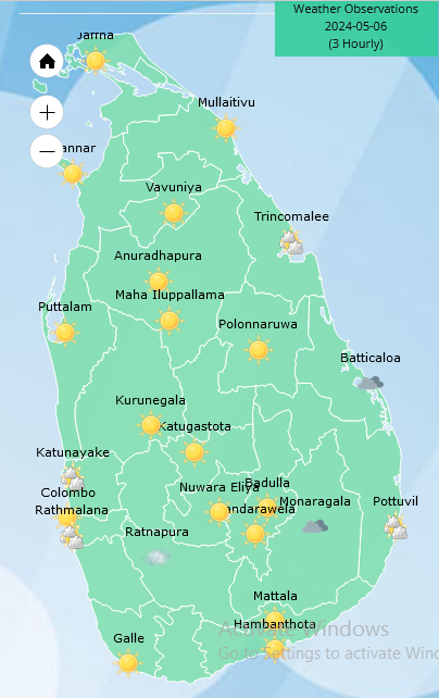
Weather forecast issued at 05.30 a.m. on 06 May 2024 by the Department of Meteorology
Misty conditions can be expected at some places in Central and Sabaragamuwa provinces during the morning.
A few showers may occur over the coastal areas of Puttalam to Galle via Colombo during the morning while showers or thundershowers will occur at several places in Western, Sabaragamuwa, North-western, North-central and Central provinces and in Mannar, Vavuniya, Mullaitivu, Galle and Matara districts after 2.00 p.m.
Winds will be southwesterly or variable and wind speed will be (20-30)kmph. Wind speed may increase up to (40-45) kmph at times in the sea areas off the coasts extending from Puttalam to Kankasanthurai via Mannar and from Batticaloa to Hambanthota via Pottuvil.
The sea areas off the coasts extending from Puttalam to Kankasanthurai via Mannar and from Batticaloa to Hambanthota via Pottuvil can be fairly rough at times. Strong gusty winds and very rough seas can be expected during thundershowers.
The swell waves (about 2.0 m – 2.5 m) height and wave period (about 14s-16s) may increase in the sea areas off the coast extending from Kalpitiya to Pottuvil via Colombo, Galle, and Hambantota. Therefore, there is a possibility that near shore sea areas off the coast extending from Colombo to Matara via Galle, may experience surges due to swell waves.
General public is kindly requested to take adequate precautions to minimize damages caused by temporary localized strong winds and lightning during thundershowers





Weather
Heavy showers about 100 mm are likely at some places in the Northern, North-central, Central, Eastern, North-western and Uva provinces

WEATHER FORECAST FOR 20 OCTOBER 2026
Issued at 05.30 a.m. on 20 October 2026 by the Department of Meteorology
Due to the development of an atmospheric disturbance in the lower atmosphere in the vicinity of Sri Lanka, showery condition is expected to be enhanced across the island from this evening.
Misty conditions can be expected at some places in Western, Sabaragamuwa, Central and Uva provinces during the early hours of the morning.
Showers may occur in the Northern and North-western provinces during the morning while showers or thundershowers will occur in most parts of the island after 1.00 p.m. Heavy showers about 100 mm are likely at some places in the Northern, North-central, Central, Eastern, North-western and Uva provinces.
The general public is kindly requested to take adequate precautions to minimize damage caused by temporary localized strong winds and lightning during thundershowers.

WEATHER FORECAST FOR 19 OCTOBER 2026
Issued at 05.30 a.m. on 19 October 2026 by the Department of Meteorology
Misty conditions can be expected at some places in the Western, Sabaragamuwa, Central and Uva provinces during the early hours of the morning.
Showers may occur in the coastal areas of the Western and Northern provinces and Galle district during the morning.
Showers or thundershowers will occur in most parts of the island after 1.00 p.m. Fairly heavy showers above 75 mm are likely at some places in the Western, Sabaragamuwa, Central and Uva provinces and in Kurunegala, Polonnaruwa, Trincomalee and Mullaitivu districts.
The general public is kindly requested to take adequate precautions to minimize damage caused by temporary localized strong winds and lightning during thundershowers.
WEATHER FORECAST FOR 18 October 2026
Issued at 2.00 p.m. on 17 October 2026 by the Department of Meteorology
Misty conditions can be expected at some places in the Western, Sabaragamuwa, Central and Uva provinces during the early hours of the morning.
Shower may occur in the coastal areas of the Mannar and Jaffna districts during the morning while showers or thundershowers will occur in most parts of the island after 1.00 p.m.
Fairly heavy showers above 75 mm are likely at some places in the Sabaragamuwa, Central, North-central and Uva provinces and in Batticaloa, Trincomalee and Mullaitivu districts.
The general public is kindly requested to take adequate precautions to minimize damage caused by temporary localized strong winds and lightning during thundershowers.

Heavy showers about 100 mm are likely at some places in the Northern, North-central, Central, Eastern, North-western and Uva provinces

Molineux, Dunkley enter WPL 2027 auction with top base price of INR 50 lakh

Ranawaka accuses govt. of using JVP cadres and police to suppress political opponents

Six killed as speeding bulker crashes into vehicles, shop in Akurana

Prof. Peiris, summoned by CIABOC, appeals for Ven. Gnanasara’s release

Tusker Agbo found safe and in good health

‘Dates have the highest sugar content to fight Coronavirus’

Sunday Island 27 December – Headlines

#SundayIsland 17th December – Headlines

Sunday Island – 28th March

Sunday Island Headlines – 21 March

Sunday Island – 21st February – Headlines
-

 Latest News7 days ago
Nissanka’s return headlines Sri Lanka’s Test squad against Pakistan
-

 News6 days ago
Sri Lanka, India caught in US-Iran ship crisis
-

 Features2 days ago
Kotahena:A Small Enclave, An Extraordinary Legacy
-

 News3 days ago
Asgiri Mahanayake calls for immediate release of Gnanasara Thera
-

 Latest News7 days ago
Imran Khan’s PTI braces to fight federal takeover of Khyber Pakhtunkhwa
-

 Latest News6 days ago
Missiles intercepted near Riyadh after Saudi coalition hits Yemen fuel depot
-

 Latest News6 days ago
Kusal Mendis’ unbeaten 87 hands Sri Lanka consolation win
-

 Latest News7 days ago
Former Zimbabwe player and umpire Sarah Dambanevana dies aged 36