
Weather
Showers above 75 mm are likely at some places in Western and Sabaragamuwa provinces and in Galle, Matara, Nuwara-Eliya and Kandy districts.


WEATHER FORECAST FOR 23 MAY 2025
Issued at 05.30 a.m. on 23 MAY 2025 by the Department of Meteorology
Showers or thundershowers will occur at times in Western, Sabaragamuwa, North-western and Central provinces and in Galle and Matara districts while a few showers may occur elsewhere. Showers or thundershowers will occur at several places in Uva province and in Ampara, Batticaloa and Polonnaruwa districts during the evening or night. Fairly heavy showers above 75 mm are likely at some places in Western and Sabaragamuwa provinces and in Galle, Matara, Nuwara-Eliya and Kandy districts.
Fairly strong winds of about (30-40) kmph can be expected at times over the Western slopes of the central hills and in Northern, North-central, North-western and Southern provinces and in Trincomalee district.
The general public is kindly requested to take adequate precautions to minimize damages caused by temporary localized strong winds and lightning during thundershowers

Latest News
Flood warning issued to the Divisional Secretariat Divisions of Ganga Ihala Korale, Udapalatha, Doluwa, Udunuwara, Yatinuwara, Gangawata Korale, Harispattuwa, and Pathadumbara

Due to heavy rainfall received in the upper catchment areas of the Mahaweli River over the past few hours, there is a risk of minor flooding in the low-lying areas surrounding the Mahaweli River within the Divisional Secretariat Divisions of Ganga Ihala Korale, Udapalatha, Doluwa, Udunuwara, Yatinuwara, Gangawata Korale, Harispattuwa, and Pathadumbara.Residents living in the above mentioned areas and motorists using roads passing through these areas are urged to exercise extreme caution and remain highly vigilant regarding the prevailing situation.
Furthermore, residents living in close proximity to the Mahaweli River in these areas are advised to remain highly alert to the situation and take all necessary precautions to protect themselves from any potential flooding.The relevant disaster management authorities are requested to take all necessary measures in response to this situation.
Weather
Showers expected in the Western, Uva, Sabaragamuwa and North-western provinces and in Galle, Matara, Kandy and Nuwara-Eliya Districts.

WEATHER FORECAST FOR 19 SEPTEMBER 2026
Issued at 05.30 a.m. on 19 September 2026 by rhe Department of Meteorology
Showery weather in the Southwestern parts of the island is likely to increase during the next few days starting from today (19th).
Showers will occur at times in the Western, Sabaragamuwa and North-western provinces and in Galle, Matara, Kandy and Nuwara-Eliya Districts. Fairly heavy showers above 50 mm are likely at some places in the Sabaragamuwa province and in Kandy and Nuwara-Eliya districts.
Showers or thundershowers will occur at several places in the Uva province and in Mullaittivu, Batticaloa and Ampara districts after 2.00 p.m.
The general public is kindly requested to take adequate precautions to minimize damage caused by temporary localized strong winds and lightning during thundershowers.
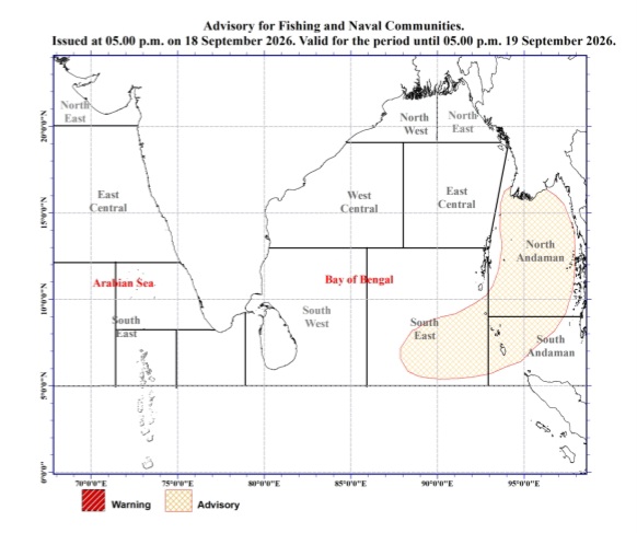
Advisory for strong winds and rough seas for Multi-day boats in the Bay of Bengal deep sea areas
Issued by the Natural Hazards Early Warning Centre
Issued at 05.00 p.m. 18 September 2026, valid for the next 24 hours.
PLEASE BE AWARE!
The atmospheric disturbance to the North of the Andaman Islands in the Bay of Bengal, is likely to develop into a low pressure area within the next 24 hours.
Due to its influence, wind speed over the Bay of Bengal sea areas will increase during the next few days starting from
tomorrow (19th).
The wind speed in the sea areas marked under the “Advisory” category on the map below will increase to 55-65 kmph at times and those sea areas will be rough or very rough at times.
Navel and fishing communities engaging the activities over this sea area are advised to be vigilant and be attentive to the future forecasts and bulletins issued by the department of Meteorology in this regards.

Flood warning issued to the Divisional Secretariat Divisions of Ganga Ihala Korale, Udapalatha, Doluwa, Udunuwara, Yatinuwara, Gangawata Korale, Harispattuwa, and Pathadumbara

Landslide Red Alerts issued to the districts of Kandy, Kegalle and Nuwara Eliya

Shafali dazzles with 49-ball unbeaten 100 and India march into Asian Games final

Development projects can deliver results to the people more quickly when the political authority and the public service work together towards a common goal – PM

Landslide Early Warnings issued to the Districts of Colombo, Galle, Kalutara, Kandy, Kegalle, Matara, Nuwara Eliya and Ratnapura

Chamari Athapaththu’s unbeaten 83 leads Sri Lanka into final

‘Dates have the highest sugar content to fight Coronavirus’

Sunday Island 27 December – Headlines

#SundayIsland 17th December – Headlines

Sunday Island – 28th March

Sunday Island Headlines – 21 March

Sunday Island – 21st February – Headlines
-

 Opinion6 days ago
From Galkissa (Mount Lavinia) to Tambuttegama
-

 News3 days ago
US embassy won’t comment on IGP’s probe into joint drug raid
-

 Features5 days ago
The emptying university: why are academics leaving?
-

 Features6 days ago
Sri Lanka’s university crisis: Brain drain and union action demand urgent reform
-

 Business3 days ago
All-new Bolero MaXX unveiled in Sri Lanka
-

 News2 days ago
Bid for Basil’s extradition nears final stage: Police
-

 Opinion6 days ago
Ashraff: From the SLMC towards the National Unity Alliance
-

 Editorial6 days ago
Muscle flexing, astroturfing and dog-and-pony shows