Life style
Amphibians going extinct in SL at a record pace

by Ifham Nizam
Sri Lanka holds the record for nearly 14 per cent of the amphibian extinctions in the world. In other words, of the 130 amphibian extinctions known to have occurred across the globe, 18 extinctions (14 per cent) have occurred in Sri Lanka, says Dr. Anslem de Silva, widely regarded as the father of Herpetology in the country. Speaking to The Sunday Island, the authors of a news book on amphibians, said that this is one of the highest number of amphibian extinctions known from a single country. Some consider this unusual extinction rate to be largely the result of the loss of nearly 70 per cent of the island’s forest cover. Dr. Anslem de Silva, Co-Chairman, Amphibian Specialist Group, International Union for the Conservation of Nature/Species Survival Commission (IUCN/SSC), together with two academics, Dr. Kanishka Ukuwela, Senior Lecture at Rajarata University, Mihintale who is 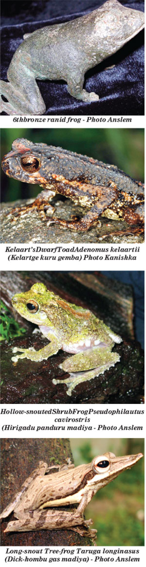 also associated with IUCN/SSC and Dr. Dillan Chaturanga, Lecture at Ruhuna University, Matara had authored this most comprehensive book on amphibians running to nearly 250 pages released last week. The prevalent levels of application of agrochemicals up to few months back, especially in rice fields, and vegetable and tea plantations, have increased over the past three decades. Similarly, the release of untreated industrial wastewater to natural water bodies has intensified. As a consequence, many streams and canals have become highly polluted, they say. The use of pesticides directly decreases the insect population, an important source of food for amphibians. Furthermore, these pollutants can easily make the water in paddy fields and the insects on which the amphibians feed toxic or increase the nitrogen content of the water. The highly permeable skins of amphibians would certainly cause them to be directly affected by these, they add. Amphibian mortality due to road traffic is a widespread problem globally that has been known to be responsible for population reductions and even local extinction in certaininstances. In Sri Lanka, amphibian mortalities due to road traffic are highly prevalent on roads that serve paddy fields, wetlands and forests. Further, they are especially intensified on rainy days when amphibian activity is high, the book explains. Recent studies indicate that amphibian road kills are exacerbated in certain national parks in the country due to increased visitation. According to recent estimates, several thousand amphibians are killed annually due to road traffic.
Professor W. A. Priyanka, PhD (USA), Professor in Zoology, Faculty of Science, University of Peradeniya says the need for a guide to the amphibian fauna of Sri Lanka is obvious, given the currently critical conditions endangering them. Amphibians are an attractive group of animals whose diversity has always sparked interest among the scientific community, creating a vast body of unanswered questions.However, the identification of amphibians has been a challenge due to the lack of a complete and informative guide. The comprehensive pictorial guide provided by the new book should thus be of great benefit to a better understanding of the unique and intriguing nature of these fascinating living beings.The authors have done an outstanding job in compiling this book. An introduction to the guide briefly describes the history, current status, threats and conservation information, along with interesting folklore associated with amphibians. With the clear and informative images, distribution maps and updated status of each species, this guide can easily be comprehended by experts and beginners in the field alike.”I firmly believe that this book will be very useful to undergraduate and postgraduate students in the fields of zoology, biology and environmental science, as well as researchers, wildlife managers and visitors,” Professor Priyanka added.The authors said that like their previous guide to the reptiles of Sri Lanka, A Naturalist’s Guide to the Reptiles of Sri Lanka (de Silva & Ukuwela, 2017, 2020), this book is intended for both naturalists and visitors to Sri Lanka, providing an introduction to the amphibians found here. It features all the extant species of amphibian in this country with colour photographs and quick and easy tips for identification. At the time of writing, 120 species have been recorded within the country and ongoing taxonomic work is certain to add more to this impressive list in the next few years.This guide provides a general introduction to the amphibians of Sri Lanka, a profile of the physiographic, climatic, and vegetation features of the island, key characteristics that can be used in the identification of amphibians and descriptions of each extant amphibian species.Additionally, it presents information on amphibian conservation here and a brief introduction to folklore and traditional treatment methods for combating poisoning due to amphibians in this country. The species descriptions are arranged under their higher taxonomic groups(orders and families), and further grouped in their respective genera.The descriptions are organized in alphabetical order by their scientific names. Every species covered is accompanied by one or more colour photograph of the animal. Each account includes the vernacular name in English, the current scientific name, the vernacular name in Sinhala, a brief history of the species, a description with identification features, and details of habitat, habits and distribution (both here and outside the country).Key external identification features of the species, such as body form, skin texture and coloration, are provided, to help in the quick identification of an animal in the field.It must be noted that according to Sri Lanka’s wildlife laws, amphibians cannot be captured or removed from their natural habitats without official permits, which must be obtained in advance from the Department of Wildlife Conservation.Sri Lanka is home to an exceptional diversity of amphibians. Currently, the island nation boasts of 112 species of amphibians of which 98 are restricted to the country. However, nearly 60 per cent of this magnificent diversity is threatened with extinction. To make matters worse, very little attention is paid by the conservation authorities or the public. The last treatise on the subject was published 15 years ago. However, many changes have taken place since then and hence an updated compilation was a major necessity. This book by the three authors intends to popularize the study of amphibians by the general public by filling this large void. Historical aspects
Sri Lanka is one of the few countries in the world where conservation and protection of its fauna and flora has been practiced since pre-Christian times. There is much archaeological, historical and literary evidence to show that from ancient times amphibians have attracted the attention of the people of this island.
This is evident by the discovery of an ancient bronze cast of a frog (see photo) discovered during excavations conducted by the Department of Archaeology and the Central Cultural Fund. Strati-graphic evidence from the excavation sites indicate that these objects belong to the sixth to eighth centuries AD (Anuradhapura and Jetavanārāma museum records). Beliefs that feature the ‘good’ qualities of frogs and association with nature. These beliefs have some positive effects on the conservation of amphibians, perhaps one reason that Sri Lanka harbours a diverse assemblage of frogs. Absence of frogs and toads in agricultural fields indicates impending crop failure, it is believed.
The authors have specially thanked Managing Director John Beaufoy of John Beaufoy Publishing Ltd, for publishing many books promoting Sri Lanka diversity.

Anita Sharma is a psychologist, who approaches the human mind with equal measures of empathy and insight. Known for her calm presence and thoughtful perspectives, she works closely with individuals navigating anxiety, relationship, trauma and the quiet emotional struggles that often go unseen. With experience working with individuals, couples and families, she has built a reputation for helping people navigate emotional challenges with clarity. Compassion and confidence. Anita Sharma stands as a reassuring voice bridging science, sensitivity and cultural understanding.
What inspired you to pursue a career in psychology?
I was inspired to pursue a career in psychology because I have always been curious about how people think and behave, especially when observing the world around us today. With so much happening in society, I often found myself wondering why people responded differently to similar situations and what influenced their choices, emotions, and behaviours. Psychology allows me to explore these questions on a deeper level and understand how factors like the environment, experiences, and social pressures shape a person’s behaviour. This interest motivated me to want to better understand others and eventually use that knowledge to make a positive impact.
How has your journey been as a psychologist? Have you faced unique challenges?
My journey as a woman in this field has required a lot of resilience and self-belief. In a world that is not always kind, there have been moments where certain spaces felt intimidating, but I chose to turn those experiences into strength rather than allow it to limit me. Instead of shrinking myself, I learned to speak up and trust my inner voice. These challenges have shaped my confidence, sharpened my perspective, and reinforced my commitment to the field.
What areas of psychology Do you specialise in and why did you choose them?
I specialize in counselling, focusing on people experiencing depression and anxiety, as well as adolescents, couples, and individuals recovering from surgery. I chose this area because I’m passionate about helping people go through life’s challenges. Supporting adolescents allows me to guide young people through critical stages of growth, counselling couples strengthens relationships, and working with individual’s post-surgery helps them cope emotionally and adjust to major life changes. Overall, this field lets me make a meaningful impact on people’s mental and emotional well-being.
How Do you approach therapy or counselling with clients facing anxiety or depression or trauma?
When working with clients facing anxiety, depression, or trauma, I approach therapy with empathy and patience. I start by creating a safe, non-judgmental space where clients feel heard and understood. I focus on understanding their experiences, thoughts, and feelings, and together we identify coping strategies and goals that are realistic and meaningful for them.
In your opinion, what are the most promising mental health challenges facing women and men?
In my opinion, some of the most pressing mental health challenges today revolve around stress, anxiety, depression, and the pressures of balancing personal and professional life. For women in particular, societal expectations, gender bias, and body image pressures can take a significant toll. Women are often expected to excel at work, manage family responsibilities, maintain social roles, and meet certain standards of weight and beauty appearances. Society frequently makes remarks or judgments about women’s bodies and looks, which lowers their self-esteem. Men also face challenges, like societal pressure to suppress emotions, which can lead to untreated stress or depression. Addressing these challenges requires awareness, supportive environments, and access to mental health resources
What role do you think society can play in reducing stigma around therapy and counselling?
Society plays a crucial role in reducing the stigma around therapy and counselling. By openly talking about mental health, sharing personal experiences, and normalizing seeking support, we can challenge the idea that needing help is a sign of weakness. Media, workplaces, schools, and communities all have a part to play in creating safe, supportive environments where people feel comfortable accessing mental health care. Education and awareness campaigns can also help people understand that therapy isn’t just for crises
Psychology can be emotionally demanding. How do you maintain your own mental health and balance work like pressures?
Psychology can definitely be emotionally demanding and it’s not a field that is suited for everyone. Maintaining my own mental health is a priority. I make a deliberate effort to detach from work at the end of the day, which allows me to process my own emotions and recharge. I also practice regular self-care, such as meditation, listening to music, and spending time with my family. Seeking supervision and peer support helps me gain perspective on challenging cases, ensuring I don’t carry that emotional weight alone
Would you say has been your most rewarding experience as a Psychologist?
Looking back, the most rewarding part of my work in psychology is hearing a client say, ‘I feel so much better after speaking to you.’ In those moments, I’m reminded that simply being present, listening without judgment, and offering support can truly make a difference in someone’s life. Knowing that I’ve helped someone feel lighter, more understood, or more hopeful is incredibly fulfilling and just reinforces why I chose this profession.
Where privacy and social perceptions matter greatly. How do you help individuals feel safe and comfortable seeking psychological support?
In a close-knit society where privacy and social perceptions are deeply valued, some women face pressures from traditional family expectations, including arranged marriages and strict cultural norms. To help them feel safe seeking psychological support, I focus on creating a space built on trust and understanding. For many, it’s the first time they can truly voice their thoughts and emotions, and helping them express themselves is incredibly empowering. By being sensitive to their cultural and societal context, I guide them towards confidence, emotional relief, and the belief that their feelings matter.
Ultimately, I hope this helps people understand the importance of mental wellbeing and seeking support when needed. I believe that at some stage, everyone can benefit from counselling. It’s not just for when you face a problem, seeking support can help you understand yourself better, manage challenges, and grow stronger. Life is always changing and nothing stays the same forever. By taking steps to care for our minds, we can move forward with clarity, courage, and a sense of inner balance, trusting that even difficult moments will pass.
By Zanita Careem ✍️

Tranquil and tropical with a rugged beauty and temperate climate, Sri Lanka’s south coast is blessed with a naturally restorative environment. On a rocky outcrop overlooking a secluded cove of golden sand, Anantara Peace Haven Tangalle Resort harnesses the nurturing qualities of its shoreline home to create a sophisticated oasis of soothing and renewal.
Entering its second decade, the resort has announced a fresh expansion of its Anantara Spa menu, enriching an already extensive range of traditional and modern therapies. Anantara Peace Haven Tangalle Resort now hosts the region’s only spa overseen by three resident Ayurveda doctors. Led by Head Ayurvedic DoctorBhagya Wellapilli, these qualified medical officers work alongside accomplished practitioners in immaculate facilities, ensuring authentic and effective experiences, delivered by the safest hands.
In addition to enhancing its wellness team, the resort has also launched the pioneering Ayurvedic beauty sanctuary, Ayu Lavanaya. Named from the Sanskrit words Ayu (life) and Lavanaya (grace), the sanctuary is a modern reimagination of a quintessential Ayurvedic parlour. It aligns physical care with deeper wellbeing through timeless rituals and ancient wisdom. Offered in a new space within the lush, floral environs of Anantara Spa, each meditative treatment at Ayu Lavanaya is formulated for immediate results and long-lasting benefits.
Signature therapies complement a full menu of Ayurvedic manicures, pedicures and eye rituals. The brightening and firming Kumkumadi Royal Facial uses the esteemed Kumkumadi oil to leave skin supple and luminous. The Kesha Revive Hair Ritual pairs a lime and onion extract head massage with warm triphala therapy to relieve tension, fortify roots and boost scalp health. The 120-minute Prana Radiance Ritual detoxifies the senses and rejuvenates vital energies through carefully crafted steps that promote release, balance and renewal. Also available are Abhyanga massages, Pizhichil Kerala-style oil baths, Sweda thermal infusions and more.
Beyond Ayurveda, the award-winning Anantara Spa has also introduced four specially curated aromatic massages, showcasing the sensory potency of the island’s indigenous ingredients. Melt away stress and tension with a Four Hand Massage in which two skilled therapists work in perfect synchronicity to induce profound relaxation. Invoking the natural healing of the ocean, a unique Seashell Massage releases muscles and improves circulation by moving polished shells in graceful, flowing strokes across the body.
Age is no barrier to bliss at Anantara Spa with tailored 30-minute Kids’ Massages for ages four to 12. Using light pressure and natural coconut oils, these gentle treatments support healthy care for growing bodies. For mums-to-be, a 60-minute Pregnancy Massage eases the back, neck, and shoulders, reducing swelling and assisting sleep to boost comfort for mother and baby throughout their shared journey.
Yoga sessions by the sea, a state-of-the-art fitness centre, and nutrient-rich menus augment all therapies and treatments, maximising every benefit and laying the foundation for long-term vitality. For more intensive healing, five-day programmes focus on inner harmony, deep sleep, natural weight management, or holistic detox and rebuilding.
“Since our doors opened, we have been honoured to continue and grow Sri Lanka’s long-lasting tradition of Ayurvedic practices and natural wellness,” said Erik Billgren, General Manager at Anantara Peace Haven Tangalle Resort. “By expanding our spa menu and opening the exciting Ayu Lavanaya sanctuary, we are proud to set a new benchmark in holistic healing for every treasured guest.”
“As a fully-trained Ayurvedic Doctor, I understand the importance of fostering a calm and welcoming environment in which guests can feel completely comfortable,” added Ms Wellapilli, Head Doctor at Anantara Peace Haven Tangalle Resort. “By offering this alongside an extensive menu of expertly delivered rituals, we are excited to redefine the possibilities for soothing stays on Sri Lanka’s beautiful south coast – now, and for many years to come.”
Life style
ITC Ratnadipa awarded prestigious 5-Star classification by Sri Lanka Tourism Development Authority

ITC Ratnadipa has been awarded the coveted 5-Star Classification Certificate by the Sri Lanka Tourism Development Authority (SLTDA), reaffirming its commitment to delivering world-class hospitality and sustainable luxury.
The certificate was formally presented by Mr. Buddhika Hewawasam, Chairman of SLTDA & SLTPB, and accepted by Mr. Keenan McKenzie, Area Manager – Sri Lanka and General Manager of ITC Ratnadipa.
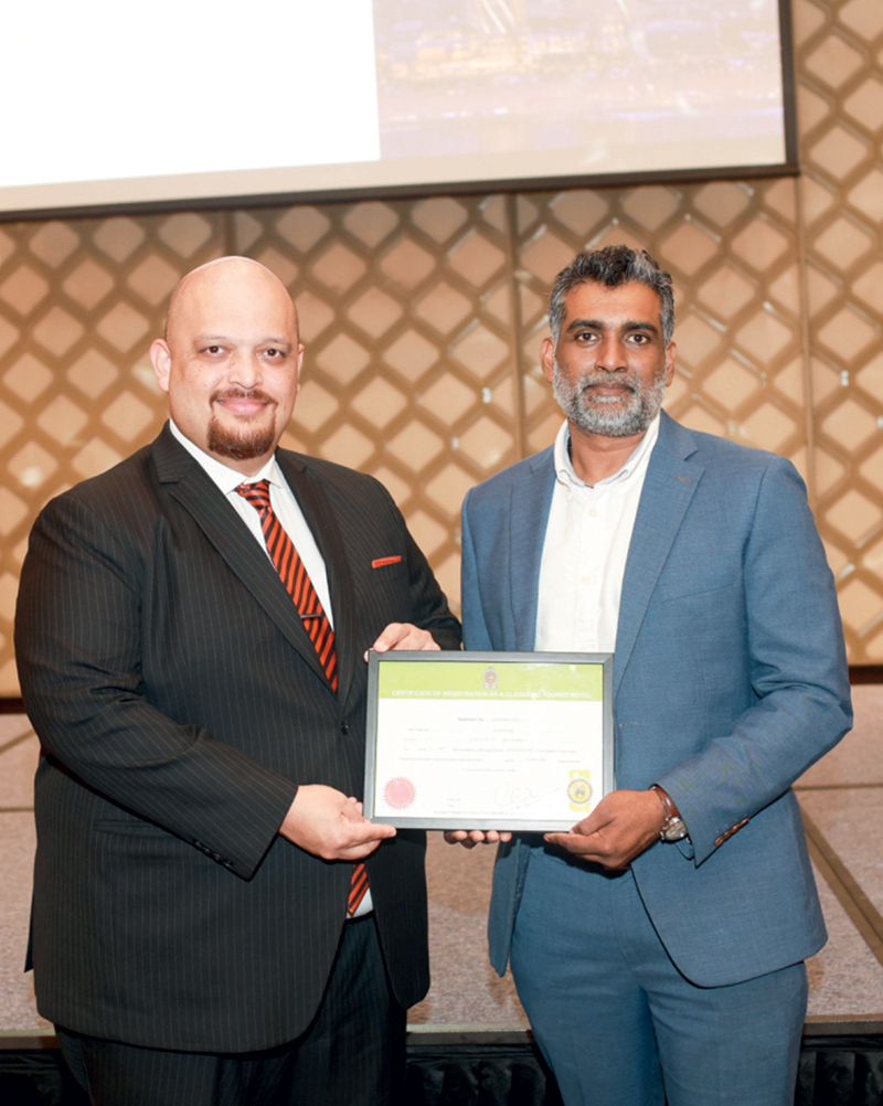
General Manager, Keenan McKenzie accepting the Certificate from Buddhika Hewawasam from SLTPB
The ceremony was attended by several distinguished officials and industry leaders, including, Board Member, SLTDA; Mrs. Malkanthi Rajapaksha, Director – Standards & Quality Assurance, SLTDA; and Mr. Trevine Gomas, Chairman, Hotels’ Classification Committee. Their presence underscored the significance of this milestone for Sri Lanka’s hospitality sector.
ITC Ratnadipa, a Luxury Collection Hotel, opened its doors in Colombo, Sri Lanka, on April 25, 2024, introducing a new benchmark in responsible luxury and sustainability-driven hospitality. Since its inception, the hotel has been committed to offering exceptional experiences that blend opulence with environmental stewardship.
Addressing the gathering, Mr. Keenan McKenzie stated:
“We are grateful to the Sri Lanka Tourism Development Authority and the Hotels’ Classification Committee for their guidance and trust, and to our partners and stakeholders for their continued support. This milestone strengthens our resolve to elevate Sri Lanka’s hospitality landscape while delivering responsible luxury rooted in sustainability.”
This recognition underscores ITC Ratnadipa’s dedication to excellence, sustainability, and its vision to redefine luxury hospitality in Sri Lanka.

Warning for deep depression over South-east Bay of Bengal Sea area

It’s 4-1 to Australia after Carey and Green complete stuttering chase at SCG

US seizes two ‘shadow fleet’ tankers linked to Venezuelan oil

Showers above 100 mm are likely at some places in the Eastern and Uva provinces and showers about 50-75 mm in other areas

Easter Sunday attacks: Govt. says wife of Katuwapitiya Church bomber alive

Indian Army Chief here

‘Dates have the highest sugar content to fight Coronavirus’

Sunday Island 27 December – Headlines

#SundayIsland 17th December – Headlines

Sunday Island – 28th March

Sunday Island Headlines – 21 March

Sunday Island – 21st February – Headlines
-

 News2 days ago
Interception of SL fishing craft by Seychelles: Trawler owners demand international investigation
-

 News2 days ago
Broad support emerges for Faiszer’s sweeping proposals on long- delayed divorce and personal law reforms
-

 News3 days ago
Private airline crew member nabbed with contraband gold
-

 News1 day ago
Prez seeks Harsha’s help to address CC’s concerns over appointment of AG
-

 News1 day ago
Govt. exploring possibility of converting EPF benefits into private sector pensions
-

 News5 days ago
Health Minister sends letter of demand for one billion rupees in damages
-

 Features2 days ago
Educational reforms under the NPP government
-

 Features3 days ago
Pharmaceuticals, deaths, and work ethics