Latest News
October 8 at the Women’s T20 World Cup: Can NZ produce another upset against trans-Tasman rivals Australia?

Sharjah, 6pm local time
These two teams had just met for a three-match T20I series which Australia, won 3-0. New Zealand also came into the tournament with a win less streak of 10 straight games but the manner in which they took on India, from ball one, belied their recent form and was the best kind of start they could have had before running into their trans-Tasman rivals. The toss many not be as crucial in Sharjah for the evening game because not as much dew is expected there, proven by the wins registered by the teams batting first there in the evening games. The pitches there have kept low, turned, and not offered much for the batters, with not even one team crossing 120, before the England vs South Africa clash
Australia squad:
Alyssa Healy (capt & wk), Darcie Brown, Ashleigh Gardner, Kim Garth, Grace Harris, Alana King, Phoebe Litchfield, Tahlia McGrath, Sophie Molineux, Beth Mooney, Ellyse Perry, Megan Schutt, Annabel Sutherland, Tayla Vlaeminck, Georgia Wareham
New Zealand squad:
Sophie Devine (capt), Suzie Bates, Eden Carson, Isabella Gaze, Maddy Green, Brooke Halliday, Fran Jonas, Leigh Kasperek, Amelia Kerr, Jess Kerr, Rosemary Mair, Molly Penfold, Georgia Plimmer, Hannah Rowe, Lea Tahuhu
Tournament form guide:
Both teams started their campaigns with emphatic wins. Defending champions Australia handed Sri Lanka a six wicket loss and New Zealand stunned India by 58 runs.
.Player to watch:
Amelia Kerr is a top allrounder, but it’s her T20I record against Australia that doesn’t do justice to her reputation. Her batting strike rate against them is under 96 with an average of under 18, and her economy rate is over seven an over even though she has picked 16 wickets – the joint most for her against any opponent – against them. She would want to leak fewer runs on today in spin-friendly conditions while continuing to take wickets, and also show her technique against spin while batting whether her team requires quick runs or a more watchful approach, depending on conditions and match situation.
[Cricinfo]
Latest News
Landslide early warnings issued to the Districts of Badulla, Kandy, Matale and Nuwara Eliya

The Landslide Early Warning Center of the National Building Research Organisation [NBRO] has issued landslide early warnings to the districts of Badulla, Kandy, Matale and Nuwara Eliya for the next 24 hours commencing at 1200hrs today [08]
Accordingly
LEVEL II AMBER landslide early warnings have been issued to the Divisional Secretaries Divisions and surrounding areas of Ududumbara in the Kandy District, Wilgamuwa in the Matale District, and Nildandahinna and Walapane in the Nuwara Eliya District.
LEVEL I YELLOW landslide early warnings have been issued to the Divisional Secretaries Divisions and surrounding areas of Meegahakiwula, Welimada, Kandaketiya, Lunugala, Badulla, Passara, Uva Paranagama and Hali_Ela in the Badulla District, Ambanganga Korale in the Matale District, and Mathurata and Hanguranketha in the Nuwara Eliya District.

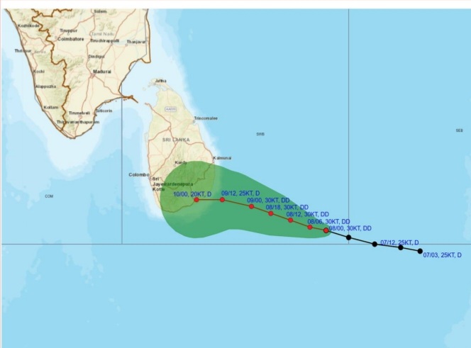
Warning for deep depression over South-east Bay of Bengal Sea area.
Issued by the Natural Hazards Early Warning Centre, Department of Meteorology at 10.30 a.m. on 08 January 2026 for the period until 10.30 a.m. 09 January 2026
The depression in the Bay of Bengal to the southeast of Sri Lanka has intensified into a deep depression and is centered near latitude 5.4°N and longitude 85.3°E, about 420 km southeast of Pottuvil at 05.30 a.m. today (08th). The above system is currently (10:00 a.m.) located about 300 km southeast of Pottuvil.
It is very likely to move west-northwestwards across the southwest Bay of Bengal and cross the Sri Lanka coast between Hambantota and Kalmunai between 5.30 p.m. to 11.30 p.m. on Friday [9th January 2026].
Hence, showery, and windy condition over the island, particularly in the Northern, NorthCentral, Eastern, Uva and Central provinces is expected to enhance from today (08th).
For the Land area:
DAMAGE EXPECTED:
• Damage to huts, temporary shelters and light structures
• Destroy the roof tops/ sheets etc.
• Damage to power and communication lines.
• Breaking of tree branches and uprooting of large avenue trees.
• Damage to paddy crops, banana, papaya trees and orchards.
• Damage to harbor yachts
• Flash flood
• Sea water inundation in low lying areas in the near coast.
Action suggested for the Land area:
• Coastal hutment dwellers are advised to move to safer places. Other people in the affected areas to remain indoors.
• People living in hilly areas (particularly landslide prone areas) and low lying areas in river basins are requested to be vigilant.
• Drivers and people using roads in the hilly areas are requested to be vigilant.
• Beware of fallen trees and power lines.
• Avoid using wired telephones and connected electric appliances during thunderstorms.
• General public is requested to be vigilant regarding impending extreme weather situation.
• For emergency assistance contact the local disaster management authorities.
• Requested to be attentive about future advisories issued by the Department of Meteorology in this regard.


Landslide early warnings issued to the Districts of Badulla, Kandy, Matale and Nuwara Eliya

Coe commits World Athletics support to Jamaica

Rare mountain gorilla twins born in Africa’s oldest national park

ECB launch ‘thorough review’ in wake of 4-1 Ashes defeat

Warning for deep depression over South-east Bay of Bengal Sea area

It’s 4-1 to Australia after Carey and Green complete stuttering chase at SCG

‘Dates have the highest sugar content to fight Coronavirus’

Sunday Island 27 December – Headlines

#SundayIsland 17th December – Headlines

Sunday Island – 28th March

Sunday Island Headlines – 21 March

Sunday Island – 21st February – Headlines
-

 News3 days ago
Interception of SL fishing craft by Seychelles: Trawler owners demand international investigation
-

 News3 days ago
Broad support emerges for Faiszer’s sweeping proposals on long- delayed divorce and personal law reforms
-

 News4 days ago
Private airline crew member nabbed with contraband gold
-

 News2 days ago
Prez seeks Harsha’s help to address CC’s concerns over appointment of AG
-

 News2 days ago
Govt. exploring possibility of converting EPF benefits into private sector pensions
-

 Features3 days ago
Educational reforms under the NPP government
-

 News6 days ago
Health Minister sends letter of demand for one billion rupees in damages
-

 Features4 days ago
Pharmaceuticals, deaths, and work ethics