Features
Myanmar…..unlike any land you know about
by ACB Pethiyagoda
A desire to visit Burma (Myanmar since 1989) having seen the film ‘The Story of Dr. Wossell’ as a school boy was fulfilled recently. The film was about a dedicated British Army Medical Officer who during World War II fell in love with the country and more deeply with a lithesome and compassionate Buddhist Burmese lady and chose to remain with her in her country after demobilization.
Several books, fiction and non-fiction of the country read over the years made the desire greater. However, Burma’s isolation from the rest of the world since 1962 when the military junta known as the State Law and Order Restoration Council (SLORC) seized power, rumours of political unrest, and later the house arrest of the Nobel Peace Prize winner and leader of the National League for Democracy, Aung San Sun Kyi made one think twice about making the journey. However, recently people spoke of trickles of tourists flowing into the country and we, a party of five, including my sister followed suit.
Yangon the capital city known as Rangoon up to 1989 is also the international airport. On arrival Customs and Immigration formalities were gone through without the feared hassle. Every foreign visitor however is required to purchase Foreign Exchange Certificates (FECS) for at least US$ 200. The dollar is presently valued at 350 Kyats (pronounced chat) and is presently the official rate of exchange but encashable up to 400 Kyats or more when payments for purchases are made in US dollars or FECs.
There are about 150 licensed hotels in Yangong which are authorized to receive foreign guests in addition to locals. On the top of the range is The Strand (in existence from British times) at around US$ 400 a night with dinner or lunch at US$ 25 and high tea at US$ 10 per person! In the Traders Hotel and Hotel Equatorial, rooms are about half that price. In the budget range there are very many hotels and guesthouses at about US$ 30 double and US$ 20 single with AC, attached bathroom, hot and cold water, mini fridge, good linen and comfortable beds which are more than adequate for the normal tourist. In addition a breakfast of juice, eggs, toast, tea or coffee is included. Payments by foreigners for hotel accommodation are strictly in US dollars or FECs.
Clean and tasty meals of rice or noodles with vegetables, chicken or fish at a little less than US$2 are available in this type of hotel. Hundreds of middle range restaurants which serve Western, Indian, Chinese and Burmese food are found all over Yangon.
Yangon has a population of around four million out of 89 million in the country. It is clean and roads, some with six lanes for traffic, are lined with ornamental trees and flowering shrubs at the center and beyond the wide pavements on both sides. Residential areas of the wealthy where some of the foreign embassies are located are more like the best areas of Singapore, Bangkok, Jakarta etc. No doubt there are the seamy sides of the city but prudent tourists avoid those here or in any country unless they are seeking unnecessary trouble!
A very notable feature is that these roads are well maintained, even those outside the capital, and are completely devoid of refuse not even scraps of paper or other litter. That goes for the bazaars as well (Scott market being the most popular) and the other commercial areas. Pavements of many of these areas, particularly in the evenings, are converted into open air eating houses with low plastic stools for patrons who are served with a variety of food from rice, noodles, soups, barbecued meats of various kinds, to beer, tea and other beverages.
In these bazaars the normal tourist looking for gifts or souvenirs would be attracted by exquisitely carved wooden ornaments, jade jewellery, gem stones (rubies and sapphires), cotton and silk longyi (lungi) – all truly Burmese. As in any other country if one wants to be doubly sure of quality, tourists’ shops located in the better residential areas and the upper class shopping malls would be the choice.
Practically, everyone in the country, rich or poor, in whatever occupation from shop assistants to Government employees, and professionals, other than those in their regulation uniforms, wear the longyi – the Burmese unisex sarong. Men normally wear small checked cotton sarongs well above the ankle with a rather prominent knot in front and with their wallets tucked at the back; perhaps a bit risky in crowded areas.
Women wear very colourful longyis with one end tucked into the side. Men wear western style shirts or less often tunic style collarless shirts above the sarong while the upper garments worn by women are loose blouses in varying styles and colours to match the longyi. This dress is so very sensible, particularly for men in a hot tropical climate and is also very elegant while class distinctions created by different types and styles of western clothing do not arise.
More men in Sri Lanka should adopt this form of dress particularly during non-working hours as casual wear in the evenings – the writer has done that for the last 40 years. Men in two piece suits are a definite rarity and they also do not normally wear the headgear which used to be seen in photographs of leading Burmese men in earlier years. Both men and women wear slippers or sandals and hardly anyone is seen in socks and shoes or barefoot.
With King Anawarahta’s ascendance to the throne in 1044 Burma’s history began to be written and from 1057 it became a Buddhist state. In 1472 King Dhamma Zedi caused a revival of Buddhist culture and during his reign contact with European countries, mainly British, Dutch and French commenced. After several other Burmese Kings, the British took over Mandalay (700 km. North of Yangon) and the surrounding areas after the most ruthless crushing of any opposition to their onward march and consolidation of its power over the whole of Burma which became a part of British India.
In 1942 the Japanese having driven the British out declared Burma an independent country. However, due to their harsh rule a strong anti-Japanese feeling arose and towards the end of World War II the British took control of the country again. On January 27, 1947, 37-year old General Aung San and Prime Minister Clement Atlee signed an agreement for the formation of a Constituent Assembly after a general election.
Aung San’s party won by a majority of 53 seats but in July 1947 he and six of his assistants were assassinated. On January 4, 1948 Independence was granted to Burma with General Aung San’s second in command, U Nu as leader of the country. Since then the country has had continuous political problems with one rebel group or another until the SLORC imposed martial law and took control of the country.
In May 1990 the National League for Democracy led by Aung San Sun Kyi (daughter of the late General Aung San) won a general election with a majority of 93 seats but the ruling military junta continues in power to date having called itself the State Peace and Development Council (SPDC) with 19 Members replacing the former SLORC with 27 members.
Throughout this tumultuous period of Myanmar’s history one aspect of life remained calm, constant and undeterred; veneration of Lord Buddha and adherence to His teachings which were introduced by the Indian Emperor Asoka the Great in the third century BC. This was later followed by frequent visits by Sinhala Buddhist missionaries between the sixth and 10th centuries resulting even now with Sri Lankan visitors often being accepted with a greater degree of cordiality than other foreigners.
Eighty seven percent of the Burmese practice Theravada Buddhism which as is known to us teaches one to work towards ones own salvation through acceptance of the Four Noble Truths and practice of the Eight Precepts. Meditation or correctly called insight awareness based on instructions of the Maha Satipattana is practiced widely by the young and old in temples and their homes as a daily ritual.
Several centres in Yangong teach the discipline to foreigners and locals; and in some simple food and lodging are provided free of charge provided the followers adhere to the rigorous house rules. These are long periods of practice from early dawn to mid morning and in the late evenings, following the Eight Precepts, refraining from solid food after the noon meal and dressing simply and modestly throughout the training period which can be a few weeks or months according to each individuals need.
In all Buddhist temples one cannot fail to notice the deep sense of serenity of the worshipers, groups or individuals in meditation, absolute cleanliness although perhaps thousands pass through each day. Also seen is the absence of tills. Flower offerings and oil lamps with lighting of candles and joss sticks are confined to small and limited areas. Bo trees are seldom seen in temples and the few that are seen have smaller leaves than our Bo trees. Instead of ‘bathing’ these trees, the common practice among the Burmese is to pour water over small statues of the Buddha placed beside small ponds with sprinklings of flowers: one cup of water for each year of life and one extra for future years.
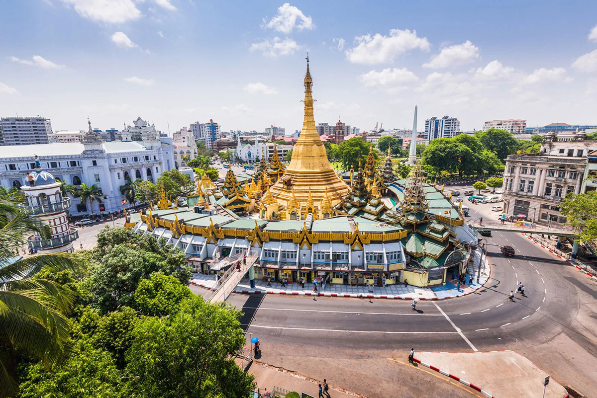
The Shwedagon Paya is the most famous of dagabas or temples in Yangon and Myanmar. It stands on a hillock 190 feet above sea level, 321 feet high from its base, covered in beaten gold, a truly awe inspiring sight particularly early in the morning or late evening. It was built about 2,500 years ago, repaired several times after damage due to earthquakes and enshrines eight strands of the Buddhas hair relics which were brought in to the countryfrom India by two Burmese merchant brothers.
In 1852 British soldiers occupied the premises for 77 years up to 1929, plundered and desecrated the temple and even took away among other treasures a 23-ton bell which accidentally fell into the Yangon River when loading into a ship for transfer to England. Many years later it was retrieved by the Burmese and placed in its original location.
In Prome some 150 miles from Yangon is the hallowed Shwesandaw Paya overlooking the Ayeyarwardy (Irawawaddy) River. Here pilgrims are taken to the base of the dagaba from the bottom of the hill it stands on by a slightly creaky electric lift for which a few Kyats are charged. This edifice is one meter taller than the Shwedagon and is a beautiful sight in the evenings when floodlit. As in the Shwedagon Paya premises hundreds of worshippers pass through daily at all hours in silence and with great piety.
Ten miles south of Prome on the road to Yangong is a temple with a huge statue of the Buddha in the sitting position defiled with a pair of gold rimmed spectacles. To say the least it is bizzare and the serenity of the face is lost.
The story goes that a long time ago a wealthy man of the area was going blind and vowed to gift the existing statue with a pair of spectacles if the treatment he was undergoing answered. He was cured and the vow was fulfilled. Strangely, years later the Christian wife of a British officer in Pyay in colonial times was also said to have been cured of an eye ailment and she too fulfilled a vow by donating a pair of eye glasses to the statue. It is not clear whose gift is seen today. However, one wishes that these two people when cured did not so unfeelingly desecrate a beautiful statue but expressed their gratitude by adding to the sanctity of the temple by other means.
Writing about the practice of religion in Myanmar mention must be made that there are small numbers of Theravada Buddhists, Hindus and Christians, mostly Baptists. Their places of worship are occasionally seen in the city and outside.
Myanmar, specially Yangon is a mixture of a certain degree of modernity and true ‘Burmese-ness;’ values which are a Buddhist way of life, respect for elders in the family or outside, all forms of life, modest simple dress, polite and dignified behaviour. There is evidence of poverty alongside indications of wealth and luxury but true Buddhist culture appears to pervade throughout all sections of society.
Having been cut off from the rest of the world for about 40 years has had its benefits and disadvantages depending on circumstances and situations and what values one looks for.
About 100 years ago Rudyard Kipling’s companion said to him, “This is Burma and it will be quite unlike any land you know about”. How very true even today and may it be that way in the years to come.
(This article by the late author was published in 2001)
Features
Cyclones, greed and philosophy for a new world order

Further to my earlier letter titled, “Psychology of Greed and Philosophy for a New World Order” (The Island 26.11.2025) it may not be far-fetched to say that the cause of the devastating cyclones that hit Sri Lanka and Indonesia last week could be traced back to human greed. Cyclones of this magnitude are said to be unusual in the equatorial region but, according to experts, the raised sea surface temperatures created the conditions for their occurrence. This is directly due to global warming which is caused by excessive emission of Greenhouse gases due to burning of fossil fuels and other activities. These activities cannot be brought under control as the rich, greedy Western powers do not want to abide by the terms and conditions agreed upon at the Paris Agreement of 2015, as was seen at the COP30 meeting in Brazil recently. Is there hope for third world countries? This is why the Global South must develop a New World Order. For this purpose, the proposed contentment/sufficiency philosophy based on morals like dhana, seela, bhavana, may provide the necessary foundation.
Further, such a philosophy need not be parochial and isolationist. It may not be necessary to adopt systems that existed in the past that suited the times but develop a system that would be practical and also pragmatic in the context of the modern world.
It must be reiterated that without controlling the force of collective greed the present destructive socioeconomic system cannot be changed. Hence the need for a philosophy that incorporates the means of controlling greed. Dhana, seela, bhavana may suit Sri Lanka and most of the East which, as mentioned in my earlier letter, share a similar philosophical heritage. The rest of the world also may have to adopt a contentment / sufficiency philosophy with strong and effective tenets that suit their culture, to bring under control the evil of greed. If not, there is no hope for the existence of the world. Global warming will destroy it with cyclones, forest fires, droughts, floods, crop failure and famine.
Leading economists had commented on the damaging effect of greed on the economy while philosophers, ancient as well as modern, had spoken about its degenerating influence on the inborn human morals. Ancient philosophers like Plato, Aristotle, and Epicurus all spoke about greed, viewing it as a destructive force that hindered a good life. They believed greed was rooted in personal immorality and prevented individuals from achieving true happiness by focusing on endless material accumulation rather than the limited wealth needed for natural needs.
Jeffry Sachs argues that greed is a destructive force that undermines social and environmental well-being, citing it as a major driver of climate change and economic inequality, referencing the ideas of Adam Smith, John Maynard Keynes, etc. Joseph Stiglitz, a Nobel Laureate economist, has criticised neoliberal ideology in similar terms.
In my earlier letter, I have discussed how contentment / sufficiency philosophy could effectively transform the socioeconomic system to one that prioritises collective well-being and sufficiency over rampant consumerism and greed, potentially leading to more sustainable economic models.
Obviously, these changes cannot be brought about without a change of attitude, morals and commitment of the rulers and the government. This cannot be achieved without a mass movement; people must realise the need for change. Such a movement would need leadership. In this regard a critical responsibility lies with the educated middle class. It is they who must give leadership to the movement that would have the goal of getting rid of the evil of excessive greed. It is they who must educate the entire nation about the need for these changes.
The middle class would be the vanguard of change. It is the middle class that has the capacity to bring about change. It is the middle class that perform as a vibrant component of the society for political stability. It is the group which supplies political philosophy, ideology, movements, guidance and leaders for the rest of the society. The poor, who are the majority, need the political wisdom and leadership of the middle class.
Further, the middle class is the font of culture, creativity, literature, art and music. Thinkers, writers, artistes, musicians are fostered by the middle class. Cultural activity of the middle class could pervade down to the poor groups and have an effect on their cultural development as well. Similarly, education of a country depends on how educated the middle class is. It is the responsibility of the middle class to provide education to the poor people.
Most importantly, the morals of a society are imbued in the middle class and it is they who foster them. As morals are crucial in the battle against greed, the middle class assume greater credentials to spearhead the movement against greed and bring in sustainable development and growth. Contentment sufficiency philosophy, based on morals, would form the strong foundation necessary for achieving the goal of a new world order. Thus, it is seen that the middle class is eminently suitable to be the vehicle that could adopt and disseminate a contentment/ sufficiency philosophy and lead the movement against the evil neo-liberal system that is destroying the world.
The Global South, which comprises the majority of the world’s poor, may have to realise, before it is too late, that it is they who are the most vulnerable to climate change though they may not be the greatest offenders who cause it. Yet, if they are to survive, they must get together and help each other to achieve self-sufficiency in the essential needs, like food, energy and medicine. Trade must not be via exploitative and weaponised currency but by means of a barter system, based on purchase power parity (PPP). The union of these countries could be an expansion of organisations,like BRICS, ASEAN, SCO, AU, etc., which already have the trade and financial arrangements though in a rudimentary state but with great potential, if only they could sort out their bilateral issues and work towards a Global South which is neither rich nor poor but sufficient, contented and safe, a lesson to the Global North. China, India and South Africa must play the lead role in this venture. They would need the support of a strong philosophy that has the capacity to fight the evil of greed, for they cannot achieve these goals if fettered by greed. The proposed contentment / sufficient philosophy would form a strong philosophical foundation for the Global South, to unite, fight greed and develop a new world order which, above all, will make it safe for life.
by Prof. N. A. de S. Amaratunga
PHD, DSc, DLITT
Features
SINHARAJA: The Living Cathedral of Sri Lanka’s Rainforest Heritage

When Senior biodiversity scientist Vimukthi Weeratunga speaks of Sinharaja, his voice carries the weight of four decades spent beneath its dripping emerald canopy. To him, Sri Lanka’s last great rainforest is not merely a protected area—it is “a cathedral of life,” a sanctuary where evolution whispers through every leaf, stream and shadow.
“Sinharaja is the largest and most precious tropical rainforest we have,” Weeratunga said.
“Sixty to seventy percent of the plants and animals found here exist nowhere else on Earth. This forest is the heart of endemic biodiversity in Sri Lanka.”
A Magnet for the World’s Naturalists
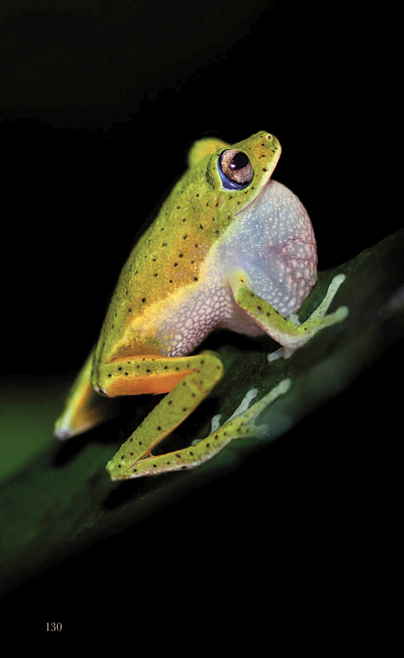
Sinharaja’s allure lies not in charismatic megafauna but in the world of the small and extraordinary—tiny, jewel-toned frogs; iridescent butterflies; shy serpents; and canopy birds whose songs drift like threads of silver through the mist.
“You must walk slowly in Sinharaja,” Weeratunga smiled.
“Its beauty reveals itself only to those who are patient and observant.”
For global travellers fascinated by natural history, Sinharaja remains a top draw. Nearly 90% of nature-focused visitors to Sri Lanka place Sinharaja at the top of their itinerary, generating a deep economic pulse for surrounding communities.
A Forest Etched in History
Centuries before conservationists championed its cause, Sinharaja captured the imagination of explorers and scholars. British and Dutch botanists, venturing into the island’s interior from the 17th century onward, mapped streams, documented rare orchids, and penned some of the earliest scientific records of Sri Lanka’s natural heritage.
These chronicles now form the backbone of our understanding of the island’s unique ecology.
The Great Forest War: Saving Sinharaja
But Sinharaja nearly vanished.
In the 1970s, the government—guided by a timber-driven development mindset—greenlit a Canadian-assisted logging project. Forests around Sinharaja fell first; then, the chainsaws approached the ancient core.
“There was very little scientific data to counter the felling,” Weeratunga recalled.
- Poppie’s shrub frog
- Endemic Scimitar babblers
- Blue Magpie
“But people knew instinctively this was a national treasure.”
The public responded with one of the greatest environmental uprisings in Sri Lankan history. Conservation icons Thilo Hoffmann and Neluwe Gunananda Thera led a national movement. After seven tense years, the new government of 1977 halted the project.
What followed was a scientific renaissance. Leading researchers—including Prof. Savithri Gunathilake and Prof. Nimal Gunathilaka, Prof. Sarath Kottagama, and others—descended into the depths of Sinharaja, documenting every possible facet of its biodiversity.
“Those studies paved the way for Sinharaja to become Sri Lanka’s very first natural World Heritage Site,” Weeratunga noted proudly.
- Vimukthi
- Nadika
- Janaka
A Book Woven From 30 Years of Field Wisdom
For Weeratunga, Sinharaja is more than academic terrain—it is home. Since joining the Forest Department in 1985 as a young researcher, he has trekked, photographed, documented and celebrated its secrets.
Now, decades later, he joins Dr. Thilak Jayaratne, the late Dr. Janaka Gallangoda, and Nadika Hapuarachchi in producing, what he calls, the most comprehensive book ever written on Sinharaja.
“This will be the first major publication on Sinharaja since the early 1980s,” he said.
“It covers ecology, history, flora, fauna—and includes rare photographs taken over nearly 30 years.”
Some images were captured after weeks of waiting. Others after years—like the mysterious mass-flowering episodes where clusters of forest giants bloom in synchrony, or the delicate jewels of the understory: tiny jumping spiders, elusive amphibians, and canopy dwellers glimpsed only once in a lifetime.
The book even includes underwater photography from Sinharaja’s crystal-clear streams—worlds unseen by most visitors.
A Tribute to a Departed Friend
Halfway through the project, tragedy struck: co-author Dr. Janaka Gallangoda passed away.
“We stopped the project for a while,” Weeratunga said quietly.
“But Dr. Thilak Jayaratne reminded us that Janaka lived for this forest. So we completed the book in his memory. One of our authors now watches over Sinharaja from above.”
An Invitation to the Public
A special exhibition, showcasing highlights from the book, will be held on 13–14 December, 2025, in Colombo.
“We cannot show Sinharaja in one gallery,” he laughed.
“But we can show a single drop of its beauty—enough to spark curiosity.”
A Forest That Must Endure
What makes the book special, he emphasises, is its accessibility.
“We wrote it in simple, clear language—no heavy jargon—so that everyone can understand why Sinharaja is irreplaceable,” Weeratunga said.
“If people know its value, they will protect it.”
To him, Sinharaja is more than a rainforest.
It is Sri Lanka’s living heritage.
A sanctuary of evolution.
A sacred, breathing cathedral that must endure for generations to come.
By Ifham Nizam
Features
How Knuckles was sold out

Leaked RTI Files Reveal Conflicting Approvals, Missing Assessments, and Silent Officials
“This Was Not Mismanagement — It Was a Structured Failure”— CEJ’s Dilena Pathragoda
An investigation, backed by newly released Right to Information (RTI) files, exposes a troubling sequence of events in which multiple state agencies appear to have enabled — or quietly tolerated — unauthorised road construction inside the Knuckles Conservation Forest, a UNESCO World Heritage site.
At the centre of the unfolding scandal is a trail of contradictory letters, unexplained delays, unsigned inspection reports, and sudden reversals by key government offices.
“What these documents show is not confusion or oversight. It is a structured failure,” said Dilena Pathragoda, Executive Director of the Centre for Environmental Justice (CEJ), who has been analysing the leaked records.
“Officials knew the legal requirements. They ignored them. They knew the ecological risks. They dismissed them. The evidence points to a deliberate weakening of safeguards meant to protect one of Sri Lanka’s most fragile ecosystems.”
A Paper Trail of Contradictions
RTI disclosures obtained by activists reveal:
Approvals issued before mandatory field inspections were carried out
Three departments claiming they “did not authorise” the same section of the road
A suspiciously backdated letter clearing a segment already under construction
Internal memos flagging “missing evaluation data” that were never addressed
“No-objection” notes do not hold any legal weight for work inside protected areas, experts say.
One senior officer’s signature appears on two letters with opposing conclusions, sent just three weeks apart — a discrepancy that has raised serious questions within the conservation community.
“This is the kind of documentation that usually surfaces only after damage is done,” Pathragoda said. “It shows a chain of administrative behaviour designed to delay scrutiny until the bulldozers moved in.”
The Silence of the Agencies
Perhaps, more alarming is the behaviour of the regulatory bodies.
Multiple departments — including those legally mandated to halt unauthorised work — acknowledged concerns in internal exchanges but issued no public warnings, took no enforcement action, and allowed machinery to continue operating.
“That silence is the real red flag,” Pathragoda noted.
“Silence is rarely accidental in cases like this. Silence protects someone.”
On the Ground: Damage Already Visible
Independent field teams report:
Fresh erosion scars on steep slopes
Sediment-laden water in downstream streams
Disturbed buffer zones
Workers claiming that they were instructed to “complete the section quickly”
Satellite images from the past two months show accelerated clearing around the contested route.
Environmental experts warn that once the hydrology of the Knuckles slopes is altered, the consequences could be irreversible.
CEJ: “Name Every Official Involved”
CEJ is preparing a formal complaint demanding a multi-agency investigation.
Pathragoda insists that responsibility must be traced along the entire chain — from field officers to approving authorities.
“Every signature, every omission, every backdated approval must be examined,” she said.
“If laws were violated, then prosecutions must follow. Not warnings. Not transfers. Prosecutions.”
A Scandal Still Unfolding
More RTI documents are expected to come out next week, including internal audits and communication logs that could deepen the crisis for several agencies.
As the paper trail widens, one thing is increasingly clear: what happened in Knuckles is not an isolated act — it is an institutional failure, executed quietly, and revealed only because citizens insisted on answers.
by Ifham Nizam
-
News5 days ago
Lunuwila tragedy not caused by those videoing Bell 212: SLAF
-

 News7 hours ago
Over 35,000 drug offenders nabbed in 36 days
-
 News4 days ago
Level III landslide early warning continue to be in force in the districts of Kandy, Kegalle, Kurunegala and Matale
-
 Latest News7 days ago
Level III landslide early warnings issued to the districts of Badulla, Kandy, Kegalle, Kurunegala, Matale and Nuwara-Eliya
-
 Features6 days ago
Ditwah: An unusual cyclone
-

 Business2 days ago
LOLC Finance Factoring powers business growth
-

 News2 days ago
CPC delegation meets JVP for talks on disaster response
-
 News2 days ago
A 6th Year Accolade: The Eternal Opulence of My Fair Lady


