
Weather
Heavy showers above 100 mm are likely at some places in Sabaragamuwa province and in Nuwara-Eliya district

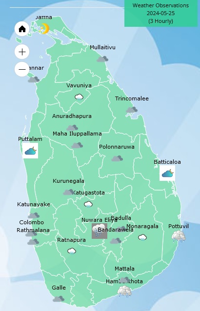
Weather forecast issued at 05.30 a.m. on 25 May 2024 by the Department of Meteorology Sri Lanka
Due to the South West Monsoon condition, the prevailing showery and windy conditions are expected to continue.
Showers or thundershowers will occur at times in Western, Sabaragamuwa, Central, North-western and Southern provinces as well as in Northern and North-central provinces. Heavy showers above 100 mm are likely at some places in Sabaragamuwa province and in Nuwara-Eliya district. Fairly heavy showers about 75 mm are likely at some places in Western and North-western provinces and in Kandy, Galle and Matara districts.
Strong winds of about (50-60) kmph can be expected at times over the Western slopes of the central hills and in Northern, North-central, Western, Southern and North-western provinces and in Trincomalee district. Fairly strong winds about (30-40) kmph can be expected at times elsewhere of the island.
Winds will be south-westerly in the sea areas around the island. Wind speed will be (40-50) kmph and may increase up to (60-70) kmph at times in the sea areas extending from Mannar to Pottuvil via Colombo, Galle and Hambantota. Wind speed will be (30-40) kmph and can increase up to (50-60) kmph at times in the other sea areas around the island.
The sea areas extending from Mannar to Pottuvil via Colombo, Galle and Hambantota will be very rough at times and Naval and fishing communities are advised not to venture into these sea areas, until further notice. The other sea areas around the island will be rough at times, therefore, naval and fishing communities in this sea area are requested to be vigilant in this regard.
The swell waves (about 2.5–3.0 m) height (this is not for land area) may increase in the sea areas off the coast extending from Mannar to Pottuvil via Kalpitiya, Colombo, Galle, and Hambantota.
Strong gusty winds and very rough seas can be expected during thundershowers.





Weather
Showers above 50 mm are likely in the Western, Sabaragamuwa and North-western provinces and in Kandy, Nuwara-Eliya, Galle and Matara districts

WEATHER FORECAST FOR 27 AUGUST 2026
Issued at 05.30 a.m. on 27 August 2026 by the Department of Meteorology
Showers will occur at times in the Western, Sabaragamuwa and North-western provinces and in Kandy, Nuwara-Eliya, Galle and Matara districts. Fairly heavy showers above 50 mm are likely at some places. Showers or thundershowers may occur at a few places in Ampara, Monaragala, Hambanthota and Batticaloa districts after 2.00 p.m. Dry weather will prevail over the other areas of the island.
Strong winds of about (40-50) kmph can be expected at times over the Western slopes of the Central hills, the Northern, North-central and North-western provinces and in Trincomalee, Monaragala, Hambantota and Matale Districts.
The general public is kindly requested to take adequate precautions to minimize damage caused by temporary localized strong winds and lightning during thundershowers.
Latest News
Advisory for High Waves for the sea areas extending from Colombo to Pottuvil via Galle, Matara and Hambantota
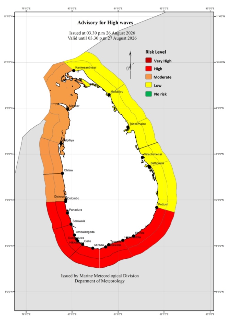
Advisory for High Waves
Issued by the Natural Hazards Early Warning Centre Issued at 03.30 p.m. on 26 August 2026 Valid for the period until 03.30 p.m. 27 August 2026
An advisory for high waves has been issued for the sea areas extending from Colombo to Pottuvil via Galle, Matara and Hambantota and naval and fishing communities engaged in activities in the aforementioned sea areas, as well as coastal communities living in the aforementioned nearshore areas, are advised to remain vigilant in this regard
The swell waves (about 2.0 m – 3.0 m) height (This is not for land area) may increase in the sea areas off the coast extending from Colombo to Pottuvil via Galle, Matara and Hambantota. There is a possibility that near shore sea areas off the coast extending from Beruwala to Matara via Galle, may experience surges due to swell waves.
Weather
Showers above 75 mm are likely at some places in the Western, Sabaragamuwa and North-western provinces and in Kandy, Nuwara-Eliya, Galle and Matara districts
WEATHER FORECAST FOR 26 AUGUST 2026
Issued at 05.30 a.m. on 26 August 2026 by the Department of meteorology
Showers will occur at times in the Western, Sabaragamuwa and North-western provinces and in Kandy, Nuwara-Eliya, Galle and Matara districts. Fairly heavy showers above 75 mm are likely at some places. A few showers may occur in Anuradhapura, Matale and Hambantota districts.
Showers or thundershowers may occur at a few places in Ampara, Monaragala and Batticaloa districts after 2.00 p.m. Dry weather will prevail over the other areas of the island.
Fairly strong winds of about (40-50) kmph can be expected at times over the Western slopes of the Central hills, the Northern, North-central and North-western provinces and in Trincomalee, Monaragala, Hambantota and Matale Districts.
The general public is kindly requested to take adequate precautions to minimize damage caused by temporary localized strong winds and lightning during thundershowers.

More than 360 dead, 1,400 missing in Nepal and Tibet after Himalayan floods

Bosnian Serb convicted war criminal Ratko Mladic dies

Prince of Wales to celebrate 150th anniversary with six-a-side cricket

Unyielding Dinusha, spirited tail hold off India to save Colombo Test

US golfer Gogel gets six-month ban for betting

UAE’s Asif Khan handed 15-month ban for using a banned substance

‘Dates have the highest sugar content to fight Coronavirus’

Sunday Island 27 December – Headlines

#SundayIsland 17th December – Headlines

Sunday Island – 28th March

Sunday Island Headlines – 21 March

Sunday Island – 21st February – Headlines
-

 News7 days ago
Country’s first woman Surveyor General appointed
-

 Business6 days ago
SriLankan Airlines makes ShakthiSAT Mission possible for talented Sri Lankan student
-

 Features7 days ago
Medical education in Sri Lanka: Then and now
-

 Latest News6 days ago
Imran Khan moved to private hospital amid deteriorating health
-

 Latest News7 days ago
Government has declared 21, 22 and 23 August 2026 as national days of mourning
-

 Features5 days ago
My secondary schooling after Royal Primary
-

 Latest News6 days ago
Tharanga edges out Chopra in 88m javelin battle
-

 News7 days ago
22A: Opp. demands all available SC judges hear petitions