News
Gazette issued on revised regulations for vehicle imports
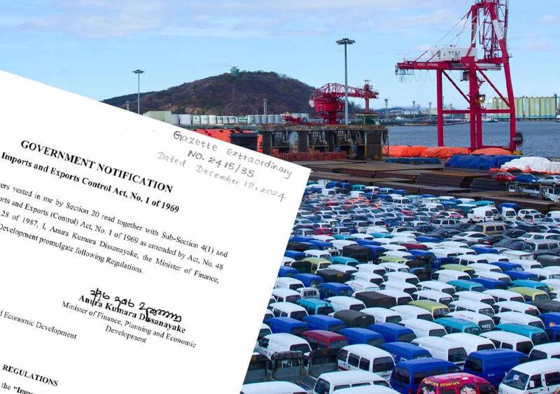
The government has issued an extraordinary gazette notification on Monday (27,) under the Import and Export Control Act, introducing revised regulations for vehicle imports.
These regulations apply to importers and commercial banks involved in vehicle import transactions and take effect immediately, the gazette said.
Key provisions in the gazette include guidelines for the re-importation of vehicles and specific criteria for importers, gazette said.
According to the notification, the Director of Sri Lanka Customs is authorized to release vehicles for which letters of credit were issued under the Imports and Exports’ regulations between December 18, 2024, and January 27, 2025.
Additionally, vehicle imports will be permitted between December 18, 2024, and July 31, 2025, under the updated guidelines, the gazette said.
Imported vehicles must be registered with the Department of Motor Vehicles in the buyer’s name within 90 days of purchase, the gazette said.
Importers and buyers are required to submit supporting documents, including their Taxpayer Identification Number (TIN), for vehicle registration, the gazette said.
Individuals who are not registered as vehicle importers with the Department of Motor Vehicles are allowed to import only one vehicle per year, the gazette said.
Registered vehicle importers who exceed 25 percent of their approved quota within a six-month period, up to December 2025, will face a three-year ban on vehicle imports, the gazette said.
Vehicles imported in violation of the new regulations must be re-exported by the importer within 90 days at their own expense, gazette said.
The updated regulations partially ease import restrictions, allowing limited vehicle imports while maintaining strict controls over quantities and compliance.
These measures aim to regulate the vehicle import process more effectively while addressing economic and administrative concerns.
Sri Lanka limited the import of vehicles from 2020 due to foreign currency shortages. (RK)


Latest News
Heat Index at ‘Caution Level’ in the Northern, North-central, North-western, Western, Eastern and Southern provinces and in Monaragala district

Warm Weather Advisory
Issued by the Natural Hazards Early Warning Centre
Issued at 3.30 p.m. on 14 April 2026, valid for 15 April 2026.
The Heat index, the temperature felt on human body is likely to increase up to ‘Caution level’ at some places in the Northern, North-central, North-western, Western, Eastern and Southern
provinces and in Monaragala district.
The Heat Index Forecast is calculated by using relative humidity and maximum temperature and this is the condition that is felt on your body. This is not the forecast of maximum temperature. It is generated by the Department of Meteorology for the next day period and prepared by using global numerical weather prediction model data.
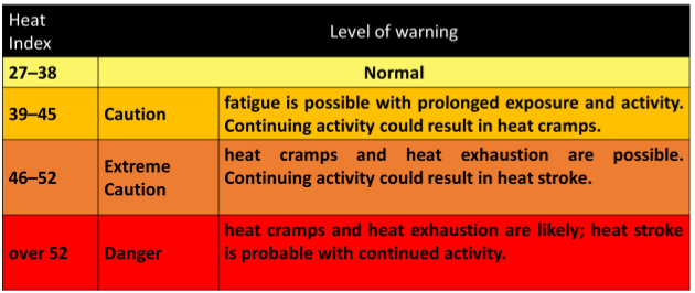
Effect of the heat index on human body is mentioned in the above table and it is prepared on
the advice of the Ministry of Health and Indigenous Medical Services.
ACTION REQUIRED
Job sites: Stay hydrated and takes breaks in the shade as often as possible.
Indoors: Check up on the elderly and the sick.
Vehicles: Never leave children unattended.
Outdoors: Limit strenuous outdoor activities, find shade and stay hydrated.
Dress: Wear lightweight and white or light-colored clothing.
Note:
In addition, please refer to advisories issued by the Disaster Preparedness & Response Division, Ministry of Health in this regard as well. For further clarifications please contact 011-7446491.
Latest News
“I extend my heartfelt wishes to all Sri Lankans for a peaceful and joyous Sinhala and Tamil New Year!” – President

President Anura Kumara Dissanayake, issuing a New Year message, extend his heartfelt wishes to all Sri Lankans for a peaceful and joyous Sinhala and Tamil New Year!
The Sinhala and Tamil New Year, which symbolises the aspiration for renewal both physically and spiritually, is the foremost cultural festival of the people of this country.
During the Sinhala and Tamil New Year, traditional customs are upheld, with priority accorded to rituals and religious observances, and activities undertaken collectively at a common auspicious time. This shared cultural practice vividly reflects our nation’s identity before the world, as well as the strong socio-cultural bonds that exist among our communities.
We firmly believe that the future path of national development can only be shaped in harmony with this invaluable culture and our distinguished historical heritage. Accordingly, it must be recalled that all our future development plans have been formulated upon the firm foundation of these precious traditions and cultural values.
Moreover, the common aspiration embodied in the customs and rituals associated with the solar transition is the nurturing of a compassionate individual who values togetherness, respects others, and lives in harmony with nature. I believe that the virtues and values of unity reflected in these New Year traditions should not be confined to these few days alone, but should instead be demonstrated throughout the year in our daily conduct.
In the face of the most significant recent natural disaster challenge encountered in the past year, we demonstrated to the world our resilience and capacity to withstand internal shocks. At the same time, in responding to the external challenges arising from the conflict in the Middle East, the Government has already set in motion a well-planned and effectively managed programme to overcome these difficulties.
As a nation, in overcoming these challenges together, I call upon all of you to further dedicate yourselves to enriching your lives through the values of togetherness, sharing, and solidarity exemplified during the Sinhala and Tamil New Year season.
As we strengthen the achievements we have secured and move forward with unwavering resolve in the face of emerging challenges, I invite everyone to join hands in unity to realise the vision of “A Thriving Nation – A Beautiful Life” for all.
I extend my heartfelt wishes to all Sri Lankans for a peaceful and joyous Sinhala and Tamil New Year!
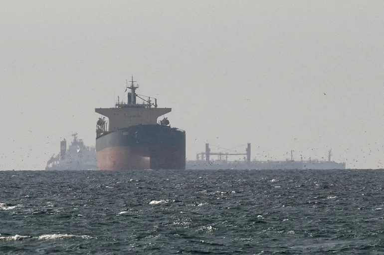
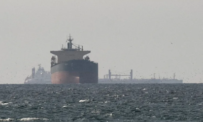
United States President Donald Trump’s planned naval blockade of Iran would further cripple international shipping, exacerbating the energy crisis roiling the global economy, analysts warn.
Oil prices surged above $100 a barrel on Monday after Trump announced that the US Navy would blockade the Strait of Hormuz and “interdict every vessel in international waters that has paid a toll to Iran”
“Iran will not be allowed to profit off this Illegal Act of EXTORTION,” Trump said on Truth Social.
Central Command, the US military’s command responsible for operations in the Middle East, said in a statement the blockade would affect only ships entering and exiting Iranian ports, an apparent scaling-back of Trump’s threat to fully block the strait.
Trita Parsi, cofounder of the US-based Quincy Institute for Responsible Statecraft, said a US blockade would have a cascading impact across the global economy.
“Anything that currently takes more oil off the market will push prices up, which in turn will push gas prices further,” Parsi told Al Jazeera.
Oil could rise above $150 a barrel if the blockade were to trigger retaliation from the Iran-aligned Houthis in Yemen, who could shut down Bab al-Mandeb, a strait that connects the Red Sea to the Gulf of Aden and Indian Ocean, Parsi said.
The strait is an alternative export route for Gulf oil and gas.
A blockade aimed at depriving Iran of revenues would mark a sudden reversal in policy by Washington.
The Trump administration last month announced it would waive some sanctions on Iranian oil exports as a way to help ease the global energy crunch.
Iran has essentially closed the strait since the start of the US-Israeli war on February 28, allowing only a small number of ships to transit after vetting and authorisation.
About 3,200 vessels were stranded west of the strait due to the blockage as of Saturday, according to the maritime intelligence company Windward.
Anas Alhajji, former chief economist at NGP Energy Capital Management, said expected non-Iranian ships would likely keep avoiding the strait despite the US military’s assurances that they will not be impeded because of elevated insurance premiums.
Ships may also fear retaliation from Iran, Alhajji said.
“Therefore, the Trump blockade of the Iranian ports is an actual blockade of the Hormuz Strait,” Alhajji told Al Jazeera.
The resulting rise in oil and gas prices would also cause the cost of chemicals, fertilisers and raw materials used to make plastics to increase, according to analysts.
Cameron Johnson, a senior partner at the Shanghai-based supply chain consultancy Tidalwave Solutions, said he expects prices of many raw materials to rise within several weeks if Trump makes good on his blockade threat.
“The wild card really is the timeframe on this,” Johnson told Al Jazeera.
“If this is a negotiating tactic – remember we still have eight or nine days left of the ceasefire – then it may not really matter. But if this prolongs itself into the end of the month and into the first week of May, you will see prices all over the world spike for raw materials.”
Deborah Elms, head of trade policy at the Hinrich Foundation in Singapore, said the situation for global supply chains could get “much worse” under the blockade.
“Some of the problems are obvious, but many are not. As an example, fabrics will get more expensive,” Elms told Al Jazeera.
“Packaging is already a challenge for firms. Many can’t get blister packs for pills or lids for consumer goods. We can expect consequences for food production later this year and into next year with fertiliser disruptions and lack of supply,” Elms said.
Chad Norville, president of the oil and gas industry news site Rigzone, said Trump’s threat is a further blow to confidence in the situation in the strait ever returning to normal.
The threat alone is likely to drive up insurance premiums for shipping and logistics companies and reduce the volume of trade passing the strait each day, he said.
“Disruptions to shipping and elevated risk in the region were already well established due to the conflict,” Norville told Al Jazeera.
“This threat doesn’t create that baseline. It amplifies it by reinforcing uncertainty around one of the world’s most critical chokepoints.”
[Aljazeera]

Showers will occur at several places in the Western, Sabaragamuwa, Central, Southern, and North-western provinces, and in Anuradhapura district after 1.00 pm.

Heat Index at ‘Caution Level’ in the Northern, North-central, North-western, Western, Eastern and Southern provinces and in Monaragala district

“I extend my heartfelt wishes to all Sri Lankans for a peaceful and joyous Sinhala and Tamil New Year!” – President

US blockade of Iran would worsen global energy crisis, analysts say

Praful Hinge’s stunning debut ends Rajasthan Royal’s four-match winning streak

“Let us resolve, with renewed determination to overcome obstacles and build a better and more prosperous nation” -PM

‘Dates have the highest sugar content to fight Coronavirus’

Sunday Island 27 December – Headlines

#SundayIsland 17th December – Headlines

Sunday Island – 28th March

Sunday Island Headlines – 21 March

Sunday Island – 21st February – Headlines
-

 News3 days ago
CEB orders temporary shutdown of large rooftop solar systems
-

 News6 days ago
AG: Coal procurement full of irregularities
-

 Business5 days ago
Israeli attack on Lebanon triggers local stock market volatility
-

 Features3 days ago
From Royal College Platoon to National Cadet Corps: 145 years of discipline, leadership, and modern challenges
-

 Business6 days ago
Hayleys Mobility introduces Premium OMODA C9 PHEV
-

 Business5 days ago
HNB Assurance marks 25 years with strategic transformation to ‘HNB Life’
-

 Sports6 days ago
DS to face St. Anthony’s in ‘Bridges of Brotherhood’ cricket encounter
-
 Latest News2 days ago
PNS TAIMUR & ASLAT arrive in Colombo