Weather
Fairly heavy showers above 75mm are likely at some places in Northern, Eastern, North-central and North-western provinces and in Matale district

Weather forecast issued at 05.30 a.m. on 17 December 2024 by the Department of Meteorology
The low pressure area over the southwest Bay of Bengal is currently (on the morning of 17th December) located to the east of the island, and It is expected to gradually move west-northwestwards, moving towards the Tamil Nadu coast near the northern coast of Sri Lanka during the next 48 hours.
Weather Forecast for today (17th of December):
Cloudy skies can be expected over most parts of the island.
Showers or thundershowers will occur at times in Northern, Eastern, North-central, Uva, Central and North-western provinces. Fairly heavy showers above 75mm are likely at some places in Northern, Eastern, North-central and North-western provinces and in Matale district. Showers or thundershowers may occur at several places elsewhere during the evening or night.
Fairly strong winds of about 40 kmph can be expected at times over Northern, North-central and North-western provinces and in Matale and Trincomalee districts.
Winds will be Northerly to North-westerly in the sea areas off the costs extending from Mannar to Pottuvil via Kankasanthurai, Trincomalee and Batticaloa. Wind speed will be (30-40)kmph and it will increase up to 50 kmph at times in these sea areas. Winds will be variable in direction in the other sea areas around the island and wind speed will be (25-35) kmph.
The sea areas off the coast extending from Mannar to Pottuvil via Kankasanthurai, Trincomalee and Batticaloa will be fairly rough at times. The other sea areas around the island will be moderate. Strong gusty winds and very rough seas can be expected during thundershowers.
The general public is kindly requested to take adequate precautions to minimize damages caused by temporary localized strong winds and lightning during thundershowers.
Latest News
Deep Depression likely to cross the Sri Lankan coast between Trincomalee and Jaffna during the morning today (10 January 2026)
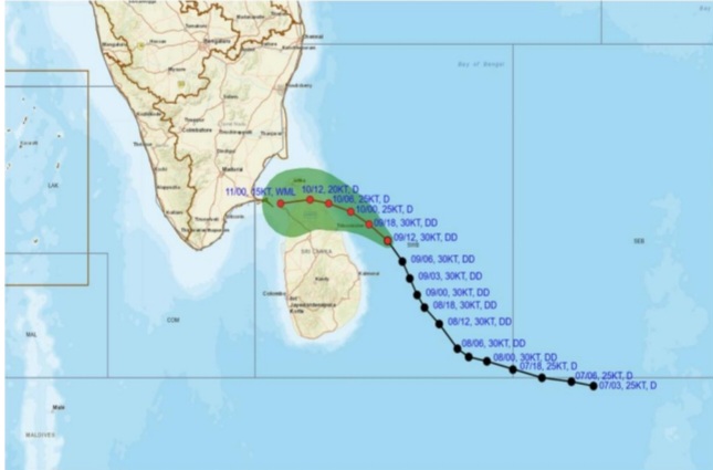
Warning for deep depression to the East of Sri Lanka.
Issued by the Natural Hazards Early Warning Centre of the Department of Meteorology at 01.30 a.m. on 10 January 2026 for the period until 01.30 a.m. on 11 January 2026
The deep depression over the southwest Bay of Bengal was located about 50 km North-northeast of Trincomalee at 01:00 a.m. on 10 January 2026. It is very likely to move northwestwards and cross the Sri Lankan coast between Trincomalee and Jaffna during the morning today (10 January 2026).
Latest News
Landslide RED warnings issued to the Divisional Secretaries Divisions of Ududumbara, Nildadndahinna and Walapane

The landslide early warning center of the National Building Research Organisation [NBRO] has issued RED warnings to the districts of Kandy and Nuwara Eliya for the next 24 hours effective from 0900 hrs today [09th January].
Accordingly,
LEVEL III RED landslide early warnings have been issued to the Divisional Secretaries Divisions and surrounding areas of Ududumbara in the Kandy district, and Nildandahinna and Walapane in the Nuwara Eliya district.
LEVEL II AMBER landslide early warnings have been issued to the Divisional Secretaries Divisions and surrounding areas of Wilgamuwa in the Matale district, and Mathurata and Hanguranketha in the Nuwara Eliya district.
LEVEL I YELLOW landslide early warnings have been issued to the Divisional Secretaries Divisions and surrounding areas of Uva Paranagama, Welimada, Kandaketiya, Badulla, Meegahakiwula, Hali_Ela, Passara and Lunugala in the Badulla district, Minipe in the Kandy district, Ambanganga Korale, Ukuwela, Rattota, Naula and Laggala_Pallegama in the Matale district, and Nuwara Eliya in the Nuwara Eliya district.
Latest News
The deep depression to the South-east of Sri Lanka is likely to intensify in to a cyclonic storm during the next 24 hours

A RED warning for a deep depression to the South-east of Sri Lanka has been issued at 01.00 a.m. on 09 January 2026 for the period until 01.00 a.m. 10 January 2026 by the Natural Hazards Early Warning Centre, of the Department of Meteorology.
The deep depression in the Bay of Bengal to the southeast of Sri Lanka (At 01:00 a.m. on Jan 9th, 2026 located about 200 km East of Pottuvil) is very likely to intensify further and move west-northwestwards towards the coast of Sri Lanka between Pottuvil and Trincomalee in the evening today (9th January 2026.) The system is likely to intensify in to a cyclonic storm
during the next 24 hours.
Hence, showery, and windy condition over the island, particularly in the Northern, North-Central, Eastern, Uva and Central provinces is expected to enhance.

De Klerk comes clutch as RCB steal last-ball thriller against Mumbai Indians

Speaker bars Parliamentary probe into Judicial Service Commission

Elephant calf killed in collision with lorry on Anuradhapura–Padeniya Road

Devananda granted bail

Opposition Leader asserts that Speaker’s ruling amounts to violation of Constitution and sovereignty of the people

PM assures Parliament no web links in modules prepared for second and third school terms under proposed reforms

‘Dates have the highest sugar content to fight Coronavirus’

Sunday Island 27 December – Headlines

#SundayIsland 17th December – Headlines

Sunday Island – 28th March

Sunday Island Headlines – 21 March

Sunday Island – 21st February – Headlines
-

 News4 days ago
Interception of SL fishing craft by Seychelles: Trawler owners demand international investigation
-

 News4 days ago
Broad support emerges for Faiszer’s sweeping proposals on long- delayed divorce and personal law reforms
-

 Opinion1 day ago
The minstrel monk and Rafiki, the old mandrill in The Lion King – II
-

 Features1 day ago
The Venezuela Model:The new ugly and dangerous world order
-

 News3 days ago
Prez seeks Harsha’s help to address CC’s concerns over appointment of AG
-

 News5 days ago
Private airline crew member nabbed with contraband gold
-

 Latest News2 days ago
Warning for deep depression over South-east Bay of Bengal Sea area
-

 News2 days ago
Indian Army Chief here