Weather
Fairly heavy showers above 75 mm are likely at some places in Western and Sabaragamuwa provinces and in Nuwara-Eliya district
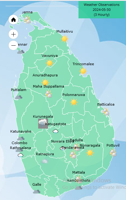
Weather forecast issued at 05.30 a.m. on 30 May 2024 by the Department of Meteorology
The prevailing showery and windy conditions over the island are expected to continue further, due to the active South West Monsoonal condition.
Showers will occur at times in Western, Sabaragamuwa, Central, North-western and Southern provinces. Showers or thundershowers will occur at a few places in Uva province and in Ampara and Batticaloa districts in the evening or night. Fairly heavy showers above 75 mm are likely at some places in Western and Sabaragamuwa province and in Nuwara-Eliya district.
Strong winds of about (50-60) kmph can be expected at times over Western slopes of the central hills and in North-central, Western, Southern and North-western provinces and in Trincomalee and Monaragala districts.
Winds will be westerly to south-westerly in the sea areas around the island. Wind speed will be (40-50) kmph and wind speed may increase up to (60-70) kmph at times.
The sea areas around the island will be rough or very rough due to the active south-west monsoonal condition. Naval and fishing communities are advised not to venture into the sea areas extending from Kankasanthurai to Pottuvil via Mannar, Colombo, Galle and Hambantota, until further notice and be vigilant in the other sea areas around the island.
Waves heights may increase up to (about 2.5 m – 3.5 m) in the sea areas off the coast, extending from Kalpitiya to Pottuvil via Colombo, Galle, and Hambantota. Therefore, there is a possibility that nearshore sea areas extending from Kalpitiya to Matara via Colombo and Galle, may experience surges due to sea waves.


Weather
Showers above 75 mm are likely at some places in the Uva province and in Batticaloa, Ampara, Hambantota and Nuwara-Eliya districts

WEATHER FORECAST FOR 05 FEBRUARY 2026
Issued at 05.30 a.m. on 05 February 2026 by the Department of Meteorology
Misty conditions can be expected at some places in the Western, Sabaragamuwa and Central provinces and in Galle, Matara and Badulla districts during the early hours of the morning.
Showers will occur at times in the Northern, North-central, Eastern, Uva and Central provinces and in Hambantota district. Fairly heavy showers above 75 mm are likely at some places in the Uva province and in Batticaloa, Ampara, Hambantota and Nuwara-Eliya districts. Showers or thundershowers may occur at several places elsewhere after 2.00 p.m. Fairly heavy
showers above 50 mm are likely at some places.
Fairly strong winds about (30-40) kmph can be expected at times over Northern and North-western provinces and in Matale, Trincomalee and Anuradhapura districts.
The general public is kindly requested to take adequate precautions to minimize damages caused by temporary localized strong winds and lightning during thundershowers.
Weather
Shower will occur in the Northern, North-central, Eastern and Uva provinces and in Nuwara-Eliya and Matale districts

WEATHER FORECAST FOR 04 FEBRUARY 2026
Issued at 05.30 a.m. on 04 February 2026 by the Department of Meteorology
Misty conditions can be expected at some places in the Western, Sabaragamuwa and Central provinces and in Galle, Matara and Badulla districts during the early hours of the morning.
Several spells of shower will occur in the Northern, North-central, Eastern and Uva provinces and in Nuwara-Eliya and Matale districts. Showers or thundershowers are likely at a few places in the Western and Sabaragamuwa provinces and in Galle and Matara districts after 2.00 p.m.
The general public is kindly requested to take adequate precautions to minimize damages caused by temporary localized strong winds and lightning during thundershowers.
Weather
Shower will occur in the Northern, North-central, Eastern and Uva provinces and in Nuwara-Eliya and Matale districts
WEATHER FORECAST FOR 03 FEBRUARY 2026
Issued at 05.30 a.m. on 03 February 2026 by the Department of Meteorology
Misty conditions can be expected at some places in the Sabaragamuwa and Central provinces and in Galle, Matara and Badulla districts during the early hours of the morning.
Several spells of shower will occur in the Northern, North-central, Eastern and Uva provinces and in Nuwara-Eliya and Matale districts. Showers or thundershowers are likely at several places in the Western and Sabaragamuwa provinces and in Galle and Matara districts after 2.00 p.m. Fairly heavy showers above 50 mm are likely at some places in these areas.
The general public is kindly requested to take adequate precautions to minimize damage caused by temporary localized strong winds and lightning during thundershowers.

SLAF men’s Judo team crowned overall champs at 62nd National Judo Championship

Showers above 75 mm are likely at some places in the Uva province and in Batticaloa, Ampara, Hambantota and Nuwara-Eliya districts

Parliament: Govt. questioned on returned cheques, delayed payments for disaster victims

President urges shedding of petty differences to achieve an economically strong Sri Lanka

PM: No withdrawal of modules introduced for Grade 6 under proposed education reforms

Lion flags flutter in Vavuniya as black flags mark Independence Day in Kilinochchi

‘Dates have the highest sugar content to fight Coronavirus’

Sunday Island 27 December – Headlines

#SundayIsland 17th December – Headlines

Sunday Island – 28th March

Sunday Island Headlines – 21 March

Sunday Island – 21st February – Headlines
-

 Opinion6 days ago
Sri Lanka, the Stars,and statesmen
-

 Business5 days ago
Hayleys Mobility ushering in a new era of premium sustainable mobility
-

 Business2 days ago
SLIM-Kantar People’s Awards 2026 to recognise Sri Lanka’s most trusted brands and personalities
-

 Business5 days ago
Advice Lab unveils new 13,000+ sqft office, marking major expansion in financial services BPO to Australia
-

 Business5 days ago
Arpico NextGen Mattress gains recognition for innovation
-

 Business4 days ago
Altair issues over 100+ title deeds post ownership change
-

 Business4 days ago
Sri Lanka opens first country pavilion at London exhibition
-

 Editorial5 days ago
Govt. provoking TUs