Features
Grandpa’s Grandpass

by Dr Srilal Fernando
Though I was born in Panadura, a small village south of Colombo, my parents moved to a property in Colombo to facilitate my travelling to school. The property was located between Grandpass and Mutwal and formed part of a large estate called Mahawatte which was a grant of 58 acres to my grandfather’s grandfather’s grandfather, Renaldus D’Andrado in 1788.
Delving into the family papers, the originals of which are in the Sri Lanka National Archives, was a fascinating journey into the history of the family and the areas around Grandpass. The documents form a folio called the D’Andrado Manuscripts, and these were published in the National Archives Journal Vol II of 1984 edited by J.H.O. Paulusz – retired Government archivist. Among these papers are the Act of appointment of Renaldus D’Andrado as Mudaliyar dated January 15, 1787, his last will, a plan of partition of his estate among his descendants, and the genealogical table of the de Fonseka, D’Andrado and related families. He was also nominated as one of the executors of his will by the Maha Mudliyar, the redoubtable Nicholas Dias Abeysinghe1 a remarkable man who died in 1795. The book Chieftains of Ceyon by J.C. Van Sandon has an account of him.
All six children of my grandfather Francis Samuel de Fonseka, had land along Mahawatte Road. I grew up there, and on return from England, built a house on the lawn of my mother’s property. My grandfather however never resided in Mahawatte, choosing to live in a house called “St Patrick’s” overlooking the Kelani River, close to the former country residence of Dutch Governors. His eldest son Patrick John de Fonseka was born on St Patrick’s Day.
Grandpass derives its name from the Portuguese who called it Grande Passo, and in British times came to be known as Grandpass. Before the arrival of the Europeans it was called Nagalagam Tota implying that it was a place of crossing the Kelani River even then. The road that runs from the river is called Nagalagam Street and joins Grandpass Road which continues to Pettah and Colombo Fort. In British times and till the 1950’s, trams ran along Nagalagam Street from Grandpass to Fort. As a child I recollect travelling in this tram. This was later replaced by trolley buses which ran along Prince of Wales Avenue later named Sirimavo Bandaranaike Mawatha. The name Grandpass suggested that there existed a small pass and indeed there was one called Petit Pas. It was at the point where there was a sluice gate over the San Sebastian Canal close to the present Colombo Kachcheri. A painting of the original building De Uytvlught on the Rijksmuseum in Amsterdam shows a splendid building which in 1852 was altered and now forms the Colombo Kachcheri. A painting of the sluice gate by J.L.K. Van Dort in 1888 exists in the Royal Institute of Linguistics and Anthropology in Leidan.
 San Sebastian Canal is a man made canal which connected the Kelani River to the Beira Lake. In older times the Beira Lake was much bigger than it is now, and connected to the Colombo Harbour close to the place where the old Parliament building stands. It was the most important waterway through which export produce was transported for shipping. Parts of the waterway still exists, but landfill has made it narrow and since the advent of the road transport, its commercial importance has deteriorated.
San Sebastian Canal joined the Kelani River at Grandpass and this became the hub where all produce transported along the river in flat bottom barges (Paruwas) was transferred on to the canals. Cinnamon, food, sand and building products were transported this way.
Grandpass was also the main ferry across the Kelani River. It was the main Gateway to Colombo and the caretaker of the ferry had an important role to play and became an income generating source for the Dutch Company. His duties included checking the locals for arms and ammunition. Iron, gunpowder and saltpetre could not be transported into the city and duties were imposed. Arrack transported into the city was taxed at this point. A toll was charged for the use of the ferry.
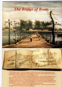
In British times it continued its importance and in 1822 the river was spanned by a “bridge of boats”, a pontoon bridge which was in use till 1895. A painting of this, by the Irish artist Andrew Nicholl in
1848 is in the Colombo Museum. An original sketch done by him, now in my possession is reproduced here. The bridge of boats consisted of 21 boats anchored side by side, and a carriageway about 500 feet long ran from Grandpass to the other side of the river. For one hour each day the land traffic was stopped and two boats moved to allow river traffic. In 1895 the Victoria Bridge was built and took its place.
There were several other ferry points across the Kelani River. One was down river near Mutwal and connected the present day Sri Wickrema Mawata to Wattala on the other side. It was called Pas Betal and was the place where the Dutch having captured Negombo entered the outskirts of Colombo. Many years later the British did the same. Other ferries existed up river at Kelani Mulla, Kaduwela and Hangwella.
Ferry Crossing at Grandpass, Watercolour, 1755, Rijksmuseum
Grandpass and its surroundings in Dutch times was the favoured area for the Governors and senior officials to build their country residences. It was easily accessed with good roads, received a cool breeze in a hot climate ,and everything grew abundantly.
Governor Rickloff Van Goens 1664-1675 had a large property which was called Van Goens Village or Van Goensdorp. His son who too became Governor improved the property. Governor Iman Falck 1765-85 had a villa in Grandpass with cinnamon planted in the garden. He encouraged the cultivation of cinnamon. Till that time what was harvested was the cinnamon growing wild.
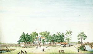
Governor Johann Van Angelbeek 1795-1796 had a country house at Grandpass. There is a detailed description of this house in Rev. James Cordiner’s, A Description of Ceylon published in 1807.
“At grandpass stands a country seat built by the late Dutch Governor Van Angelbeek. Besides a row of offices and a handsome farmyard there are two houses of one floor each for the accommodation of the family. These lie parallel to one another, and it is necessary to pass through the first to get to the second, which is raised on an embankment of the river. The stream is seen gliding along from the windows and is broad, deep and rapid. The opposite banks are clothed in thick woods.” He also mentions that after the takeover by the British, General Hay MacDowell and his staff lived there for several months at a time.
Governor’s House at Grandpass, Watercolour, Rijksmuseum
“General MacDowell was in the habit of receiving boxes of trees and shrubs by almost every ship; and one acre and a half of ground was completely filled with them”.
He introduced Mangosteen to Ceylon and it is most likely that the first plants were at Grandpass. He is also credited with introducing many other plants, including nutmeg, cloves, apples, asparagus to Ceylon.
 J.P. Lewis in his notes on Pioneers of Natural History in Ceylon says that General MacDowell on his departure in 1804 left directions with his nephew John MacDowell of the Civil Service “to give a few plants of each sort to every person who promised to nourish them”.
“His house it may be mentioned was at Grandpass, a country seat built by the late Dutch Governor Van Angelbeek”.
Lewis also mentions that Joseph Jonville, a Frenchman, was the first Superintendent of the Botanical Garden started by Governor North on the opposite bank at Peliyagoda called “Ortafoula”. Later, on Jonville’s condemnation of the first site the gardens were moved to Slave Island and named “Kew”.
Cordiner mentions that on the opposite bank of the river Governor North built a temporary bungalow where he held grand entertainments. “Excellent boats carried the party, a band and other luxuries of the feast.”.
He mentions that “on the main roads, one leading to Grandpass and the other leading to Cotta, there are many commodious houses inhabited by the Dutch and European families.
The local elite too had houses in and around Grandpass and the area leading up to Hultsdorf.
A watercolour painting of the last Dutch Governor’s house in 1757 is in the Rijksmuseum in Amsterdam. It is reproduced in Dr R.K. de Silva’s book. Two engravings, one from the front and the other from the rear is presented in Valentijn’s book of travel in 1726.
The location of the house is described in Dr R.K. de Silva’s book as North East of the present Madampitiya Road and the ferry at Grandpass. The scene shows the house looking North East from Nagalagam Street with the San Sebastian Canal on the right with the bridge over it.
Incidentally, the Town house in Colombo Fort belonging to the last Dutch Governor Van Angelbeek became the house occupied by General MacDowell for a time. It became vested in the British Government and became the King’s House, Queen’s House and now President’s House.
Large houses with extensive land, with numerous specimens of flora and fauna dotted the area extending up to Mutwal.
In British times, there is a detailed description of the Whist Bungalow in Ernst Haekel’s book “A Visit to Ceylon.” He stayed there for two weeks, a guest at the then owner Stipperger, the agent for Austrian Lloyd Shipping Company. Haeckel, a naturalist and Professor in the University of Jena, gives a very detailed description of the house and the gardens. His detailed botanical drawings inspired the Spanish Architect Antoni Gaudi. Another house in Mutwal still preserved is Elie House.
This was the preferred area of residence well into the 19th Century with schools such as St Thomas’ College starting off there. The then Catholic Bishop of Colombo acquired land to start St Joseph’s College, but eventually chose a more central location on cheaper land reclaimed from the Beira Lake. In the late 19th Century as cheap land cleared of cinnamon became available more people moved to the new area. Another factor was that the move of the main port from Galle to Colombo and the replacement of sailing ships to coal driven steam ships. This required coal bunkering. Coal was stored in old ships along the coast line near Mutwal and the wind blew the coal dust on to the shore and this became very unhygienic. Added to this, was the large scale commercialisation of the buildings leading to overcrowding and the large houses and gardens being carved up. Property prices had escalated and it was much more affordable to buy property in the recently opened Cinnamon Gardens.
Grandpass is described in most of the books on early Ceylon including the book by Robert Percival in 1803, the first book on Ceylon after the British take over.
Governor North brought in Robert Arbuthnot as the Chief Secretary for Ceylon. He in turn brought his brother George as Deputy Secretary, George kept a detailed diary which was later published by his heirs. He describes the houses occupied by General MacDowell, as quoted in the article “When North was Governor” by J.P. Lewis in the Ceylon and Antiquarian Literary Register in 1923.
An article by L.T. Gratien “Colombo in the 17th Century” in the C.A.L.R. States “at Grandpass was a noble house where Kandyan envoys used to reside when they visited Colombo. Later on, a house on Wolvendaal hill was set apart for the convoys and the house at Grandpass became the Dutch Governor’s country seat. There begun the cultivation of silkworms which gave Sedawatte its name and here in the next century was formed the first Cinnamon Estate.”
With the passage of time the areas around Grandpass has become less than salubrious. Large warehouses have come up and the area commercialised. The slums have been replaced by low to middle class housing complexes. It is no longer “Grand” and many will “Pass” by without any inkling of the rich history of the area.
References
1. The d’Andrado Manuscripts – J.H.O. Paulusz
The Sri Lanka Archives Volume 11 1984
2. Notes on some Singhalese families
Paul Pieris
3. The Chieftains of Ceylon – J.C. Van Sanden
1936
4. Changing Face of Colombo R.L. Brohier
1984
5. Old and New East Indies
Francois Valentijn 1724
6. Illustrations and Views of Dutch Ceylon 1602-1796
Dr R.K. de Silva and WGM Beumer 1988
7. Website deFonseka.com – Courtesy Jayashanth deFonseka
8. Account of Ceylon Robert Percival
1803
9. A Description of Ceylon – James Cordiner 1807
10. A Visit to Ceylon – Ernst Haekel 1883
11. When North was Governor – J.P. Lewis
Ceylon Antiquary and Literary Register 1923
12. Colombo in the 17th Century – L.J. Gratien
Ceylon Antiquary and Literary Register Volume VIII Part IV 1923
13. Good ole Grandpass Dr K.D. Paranavitana Newspaper Article 2006
14. Some pioneers of the Natural History of Ceylon – J.P. Lewis
Spolia Zeylanica 1915

 Will the Bangladesh parliamentary election bring into being a government that will ensure ethnic and religious harmony in the country? This is the poser on the lips of peace-loving sections in Bangladesh and a principal concern of those outside who mean the country well.
The apprehensions are mainly on the part of religious and ethnic minorities. The parliamentary poll of February 12th is expected to bring into existence a government headed by the Bangladesh Nationalist Party (BNP) and the Islamist oriented Jamaat-e-Islami party and this is where the rub is. If these parties win, will it be a case of Bangladesh sliding in the direction of a theocracy or a state where majoritarian chauvinism thrives?
Chief of the Jamaat, Shafiqur Rahman, who was interviewed by sections of the international media recently said that there is no need for minority groups in Bangladesh to have the above fears. He assured, essentially, that the state that will come into being will be equable and inclusive. May it be so, is likely to be the wish of those who cherish a tension-free Bangladesh.
The party that could have posed a challenge to the above parties, the Awami League Party of former Prime Minister Hasina Wased, is out of the running on account of a suspension that was imposed on it by the authorities and the mentioned majoritarian-oriented parties are expected to have it easy at the polls.
A positive that has emerged against the backdrop of the poll is that most ordinary people in Bangladesh, be they Muslim or Hindu, are for communal and religious harmony and it is hoped that this sentiment will strongly prevail, going ahead. Interestingly, most of them were of the view, when interviewed, that it was the politicians who sowed the seeds of discord in the country and this viewpoint is widely shared by publics all over the region in respect of the politicians of their countries.
Some sections of the Jamaat party were of the view that matters with regard to the orientation of governance are best left to the incoming parliament to decide on but such opinions will be cold comfort for minority groups. If the parliamentary majority comes to consist of hard line Islamists, for instance, there is nothing to prevent the country from going in for theocratic governance. Consequently, minority group fears over their safety and protection cannot be prevented from spreading.
Therefore, we come back to the question of just and fair governance and whether Bangladesh’s future rulers could ensure these essential conditions of democratic rule. The latter, it is hoped, will be sufficiently perceptive to ascertain that a Bangladesh rife with religious and ethnic tensions, and therefore unstable, would not be in the interests of Bangladesh and those of the region’s countries.
Unfortunately, politicians region-wide fall for the lure of ethnic, religious and linguistic chauvinism. This happens even in the case of politicians who claim to be democratic in orientation. This fate even befell Bangladesh’s Awami League Party, which claims to be democratic and socialist in general outlook.
We have it on the authority of Taslima Nasrin in her ground-breaking novel, ‘Lajja’, that the Awami Party was not of any substantial help to Bangladesh’s Hindus, for example, when violence was unleashed on them by sections of the majority community. In fact some elements in the Awami Party were found to be siding with the Hindus’ murderous persecutors. Such are the temptations of hard line majoritarianism.
In Sri Lanka’s past numerous have been the occasions when even self-professed Leftists and their parties have conveniently fallen in line with Southern nationalist groups with self-interest in mind. The present NPP government in Sri Lanka has been waxing lyrical about fostering national reconciliation and harmony but it is yet to prove its worthiness on this score in practice. The NPP government remains untested material.
As a first step towards national reconciliation it is hoped that Sri Lanka’s present rulers would learn the Tamil language and address the people of the North and East of the country in Tamil and not Sinhala, which most Tamil-speaking people do not understand. We earnestly await official language reforms which afford to Tamil the dignity it deserves.
An acid test awaits Bangladesh as well on the nation-building front. Not only must all forms of chauvinism be shunned by the incoming rulers but a secular, truly democratic Bangladesh awaits being licked into shape. All identity barriers among people need to be abolished and it is this process that is referred to as nation-building.
On the foreign policy frontier, a task of foremost importance for Bangladesh is the need to build bridges of amity with India. If pragmatism is to rule the roost in foreign policy formulation, Bangladesh would place priority to the overcoming of this challenge. The repatriation to Bangladesh of ex-Prime Minister Hasina could emerge as a steep hurdle to bilateral accord but sagacious diplomacy must be used by Bangladesh to get over the problem.
A reply to N.A. de S. Amaratunga
A response has been penned by N.A. de S. Amaratunga (please see p5 of ‘The Island’ of February 6th) to a previous column by me on ‘ India shaping-up as a Swing State’, published in this newspaper on January 29th , but I remain firmly convinced that India remains a foremost democracy and a Swing State in the making.
If the countries of South Asia are to effectively manage ‘murderous terrorism’, particularly of the separatist kind, then they would do well to adopt to the best of their ability a system of government that provides for power decentralization from the centre to the provinces or periphery, as the case may be. This system has stood India in good stead and ought to prove effective in all other states that have fears of disintegration.
Moreover, power decentralization ensures that all communities within a country enjoy some self-governing rights within an overall unitary governance framework. Such power-sharing is a hallmark of democratic governance.

 Valentine’s Day is all about celebrating love, romance, and affection, and this is how some of our well-known personalities plan to celebrate Valentine’s Day – 14th February:
Merlina Fernando (Singer)
Yes, it’s a special day for lovers all over the world and it’s even more special to me because 14th February is the birthday of my husband Suresh, who’s the lead guitarist of my band Mission.
We have planned to celebrate Valentine’s Day and his Birthday together and it will be a wonderful night as always.
We will be having our fans and close friends, on that night, with their loved ones at Highso – City Max hotel Dubai, from 9.00 pm onwards.
Lorensz Francke (Elvis Tribute Artiste)
On Valentine’s Day I will be performing a live concert at a Wealthy Senior Home for Men and Women, and their families will be attending, as well.
I will be performing live with romantic, iconic love songs and my song list would include ‘Can’t Help falling in Love’, ‘Love Me Tender’, ‘Burning Love’, ‘Are You Lonesome Tonight’, ‘The Wonder of You’ and ‘’It’s Now or Never’ to name a few.
To make Valentine’s Day extra special I will give the Home folks red satin scarfs.
Emma Shanaya (Singer)
I plan on spending the day of love with my girls, especially my best friend. I don’t have a romantic Valentine this year but I am thrilled to spend it with the girl that loves me through and through. I’ll be in Colombo and look forward to go to a cute cafe and spend some quality time with my childhood best friend Zulha.
JAYASRI

Emma-and-Maneeka
This Valentine’s Day the band JAYASRI we will be really busy; in the morning we will be landing in Sri Lanka, after our Oman Tour; then in the afternoon we are invited as Chief Guests at our Maris Stella College Sports Meet, Negombo, and late night we will be with LineOne band live in Karandeniya Open Air Down South. Everywhere we will be sharing LOVE with the mass crowds.
Kay Jay (Singer)
I will stay at home and cook a lovely meal for lunch, watch some movies, together with Sanjaya, and, maybe we go out for dinner and have a lovely time. Come to think of it, every day is Valentine’s Day for me with Sanjaya Alles.
Maneka Liyanage (Beauty Tips)
On this special day, I celebrate love by spending meaningful time with the people I cherish. I prepare food with love and share meals together, because food made with love brings hearts closer. I enjoy my leisure time with them — talking, laughing, sharing stories, understanding each other, and creating beautiful memories. My wish for this Valentine’s Day is a world without fighting — a world where we love one another like our own beloved, where we do not hurt others, even through a single word or action. Let us choose kindness, patience, and understanding in everything we do.
Janaka Palapathwala (Singer)

Janaka
Valentine’s Day should not be the only day we speak about love.
From the moment we are born into this world, we seek love, first through the very drop of our mother’s milk, then through the boundless care of our Mother and Father, and the embrace of family.
Love is everywhere. All living beings, even plants, respond in affection when they are loved.
As we grow, we learn to love, and to be loved. One day, that love inspires us to build a new family of our own.
Love has no beginning and no end. It flows through every stage of life, timeless, endless, and eternal.
Natasha Rathnayake (Singer)
We don’t have any special plans for Valentine’s Day. When you’ve been in love with the same person for over 25 years, you realise that love isn’t a performance reserved for one calendar date. My husband and I have never been big on public displays, or grand gestures, on 14th February. Our love is expressed quietly and consistently, in ordinary, uncelebrated moments.
With time, you learn that love isn’t about proving anything to the world or buying into a commercialised idea of romance—flowers that wilt, sweets that spike blood sugar, and gifts that impress briefly but add little real value. In today’s society, marketing often pushes the idea that love is proven by how much money you spend, and that buying things is treated as a sign of commitment.
Real love doesn’t need reminders or price tags. It lives in showing up every day, choosing each other on unromantic days, and nurturing the relationship intentionally and without an audience.
This isn’t a judgment on those who enjoy celebrating Valentine’s Day. It’s simply a personal choice.
Melloney Dassanayake (Miss Universe Sri Lanka 2024)
 I truly believe it’s beautiful to have a day specially dedicated to love. But, for me, Valentine’s Day goes far beyond romantic love alone. It celebrates every form of love we hold close to our hearts: the love for family, friends, and that one special person who makes life brighter. While 14th February gives us a moment to pause and celebrate, I always remind myself that love should never be limited to just one day. Every single day should feel like Valentine’s Day – constant reminder to the people we love that they are never alone, that they are valued, and that they matter.
I’m incredibly blessed because, for me, every day feels like Valentine’s Day. My special person makes sure of that through the smallest gestures, the quiet moments, and the simple reminders that love lives in the details. He shows me that it’s the little things that count, and that love doesn’t need grand stages to feel extraordinary. This Valentine’s Day, perfection would be something intimate and meaningful: a cozy picnic in our home garden, surrounded by nature, laughter, and warmth, followed by an abstract drawing session where we let our creativity flow freely. To me, that’s what love is – simple, soulful, expressive, and deeply personal. When love is real, every ordinary moment becomes magical.
Noshin De Silva (Actress)
Valentine’s Day is one of my favourite holidays! I love the décor, the hearts everywhere, the pinks and reds, heart-shaped chocolates, and roses all around. But honestly, I believe every day can be Valentine’s Day.
It doesn’t have to be just about romantic love. It’s a chance to celebrate love in all its forms with friends, family, or even by taking a little time for yourself.
Whether you’re spending the day with someone special or enjoying your own company, it’s a reminder to appreciate meaningful connections, show kindness, and lead with love every day.
And yes, I’m fully on theme this year with heart nail art and heart mehendi design!
Wishing everyone a very happy Valentine’s Day, but, remember, love yourself first, and don’t forget to treat yourself.
Sending my love to all of you.

 To create a powerful, natural, and hydrating beauty mask that soothes inflammation, fights acne, and boosts skin radiance, mix a mashed banana with fresh aloe vera gel.
This nutrient-rich blend acts as an antioxidant-packed anti-ageing treatment that also doubles as a nourishing, shiny hair mask.
* Face Masks for Glowing Skin:
Mix 01 ripe banana with 01 tablespoon of fresh aloe vera gel and apply this mixture to the face. Massage for a few minutes, leave for 15-20 minutes, and then rinse off for a glowing complexion.
* Acne and Soothing Mask:
Mix 01 tablespoon of fresh aloe vera gel with 1/2 a mashed banana and 01 teaspoon of honey. Apply this mixture to clean skin to calm inflammation, reduce redness, and hydrate dry, sensitive skin. Leave for 15-20 minutes, and rinse with warm water.
* Hair Treatment for Shine:
Mix 01 fresh ripe banana with 03 tablespoons of fresh aloe vera gel and 01 teaspoon of honey. Apply from scalp to ends, massage for 10-15 minutes and then let it dry for maximum absorption. Rinse thoroughly with cool water for soft, shiny, and frizz-free hair.

Namibia look to make a splash with India battling injury and illness

Powerful cyclone kills at least 31 as it tears through Madagascar port

US House votes to overturn Trump’s tariffs on Canada

Buoyed by strong support, Paudel’s Nepal search for two points against Italy

Bangladesh election 2026: Polls to open amid heavy security

Sri Lanka, minus Hasaranga, take on Oman at bogey venue

‘Dates have the highest sugar content to fight Coronavirus’

Sunday Island 27 December – Headlines

#SundayIsland 17th December – Headlines

Sunday Island – 28th March

Sunday Island Headlines – 21 March

Sunday Island – 21st February – Headlines
-
 Features4 days ago
My experience in turning around the Merchant Bank of Sri Lanka (MBSL) – Episode 3
-

 Business5 days ago
Zone24x7 enters 2026 with strong momentum, reinforcing its role as an enterprise AI and automation partner
-

 Business4 days ago
Remotely conducted Business Forum in Paris attracts reputed French companies
-

 Business4 days ago
Four runs, a thousand dreams: How a small-town school bowled its way into the record books
-

 Business4 days ago
ComBank and Hayleys Mobility redefine sustainable mobility with flexible leasing solutions
-

 Business1 day ago
Autodoc 360 relocates to reinforce commitment to premium auto care
-

 Business5 days ago
HNB recognized among Top 10 Best Employers of 2025 at the EFC National Best Employer Awards
-

 Business5 days ago
GREAT 2025–2030: Sri Lanka’s Green ambition meets a grid reality check