Features
Kandy Town I Knew In Mid-Twentieth Century
By Hm Nissanka Warakaulle
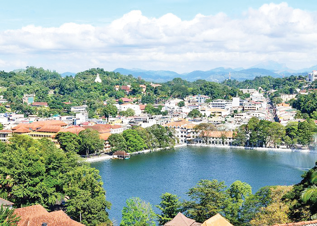
The former Kandy town now has progressed to a city. During the time Sri Lanka (then Ceylon) got independence Kandy was not a very busy town. In fact, after nine o’clock in the evening the town was dead except for very few people on the roads and in the eating houses and of course, the places where bacchanalian spirits were available.
There were no buses available after nine. From Saturday afternoon and Sunday whole day the town was devoid of any activity, except for a few hotels which were open such as the Silverdale, Paivas, East China Restaurant and the Muslim Hotel. The buses and taxis were also available till evening.
The most important landmark near the bus stand was the clock tower which had been constructed by Mr. Ismail, the owner of the motor spare parts shop close to where the clock tower stands. It was built in memory of his son who died in an accident when the vehicle he was riding went down the precipice at Kadugannawa.
Many people passing through Kandy check the time from this clock tower. From the day it was commissioned up to date it has indicated the correct time on all faces of the tower unlike most of the other clock towers that were erected in many parts of the country to coincide with the Gam Udawa.
The only stand for buses plying around Kandy and long-distance buses to places such as Anuradhapura was on the clock tower side of the road. The buses to Colombo were in the Goodshed bus stand past the railway station and the post office. In front of the old market was the stand for vehicles which included cars, vans and lorries.
The corner section in front of the Wales Theatre was the hiring car stand. Later, new bus stands were established with more buses being used. The town service buses to Peradeniya, Penideniya and Ampitiya were shifted to the new bus stand on Torrington Road. The Colombo buses had a new stand near the Technical College and the Scout Headquarters. Another bus stand was on King Street.
Up to the end of 1957 these bus stands were used by the buses of the private bus companies such as the Kandy Omnibus Company which operated the town services, the PS Bus Co. operating on the Daulagala area, the WH Bus Co. operating on the Hanguranketha area, Sri Lanka Bus Co on the Kandy -Colombo Road up to Kadugannawa, Madyamalanka Bus Co. which had the monopoly on the Gampola area and beyond and the Silverline Bus Co. operating beyond Katugastota. Once the bus services were nationalized in 1958 only the CTB buses used these bus stands.
The old market was an open building if my memory serves me right. It was octagonal in shape, with stalls all around located according to what they were selling. Vegetable stalls were in one row, fruits in another, the fish, beef and pork stalls in still another row. Dry goods and rice were in a separate area. There was no dried fish stalls in the old market as all the dried fish boutiques were at the bottom of Colombo Street which people used to refer to as the Karawala Kada Veediyan(dried fish street).
The streets in the town carried named different names from what they are today. Dalada Veediya from the Clock Tower junction up to the Dalada Maligawa was known as Ward Street with the statue of Governor Ward standing just past the Queen’s Hotel. Trincomalee Street was the old name of DS Senanayake Veediya. Yatinuwara Veediya was earlier known as Browrigg Street. Castle Hill Street is now Kotugodella Veediya. King Street is Raja Veediya. Beyond the Maligawa the road was known as Malabar Street.
With the new market coming up and with the demolition of the old one, the hiring car stand was done away with and the Wales Theatre too was demolished. The new Wales Theatre was constructed above Torrington Road. But later this too was demolished to construct the new DS Senanayake public library. Another cinema that was demolished was the Bogambara Theatre. This was demolished to give way to the new Bogambara Stadium.
Before the stadium came up, all inter- club football matches were played there. On Independence Day, we as schoolchildren participated in the march past which was also held at Bogambara. This playground was used during the Kandy Esala Perahera for the carnival which was patronized by most of the people who came to watch the Perahera.
Adjoining the Bogambara grounds was the Bogambara prison. When football matches and other events took place on Bogambara, some prisoners used to hang on the bars of the windows to watch the play. Now the prison has been shifted to Pallekele. On the other side of the Bogambara grounds was the road to the Kandy hospital and there was a bus plying from the Kandy bus stand to the hospital.
St Paul’s College was situated next to St. Paul’s Church. This school was shifted from its earlier location as it was within the Dalada Maligawa sacred area and a new school established in Asgiriya with the new name, Sri Sumangala Vidyalaya. Just near the pond with a fountain was the Magistrate’s Court. The other courts were behind the Dalada Maligawa.
Close to the Empire hotel were all the chambers of the lawyers. All these courts and lawyers’ chambers were shifted to the new court complex which came up between Getambe and Suduhumpola on the other side of the new road and railway line.
The Dalada Maligawa was not protected with barricades and vehicles going to Tennekumbura and beyond were able to go past the temple. People traveling by bus from beyond Lewella and from Talatuoya were able to alight just in front of the Temple and go in through any of the doors which were always kept open, worship and leave through any door. This unlike now where one must use the main entrance only. Now all the vehicular traffic going beyond the Temple have to go round the Kandy lake and get onto the Malabar Street through a byroad (even during a period when there is a scarcity of fuel).
Kandy town then was not that congested as it is now and there was less vehicular traffic. Parking was permitted anywhere in the town. This was possible as only a few owned vehicles at that time and most of the people used public transport. There were many rickshaws parked in many places of the town. Many people used this man drawn means of transport. In fact, when my elder brother and I were admitted to Kingswood College, we used to travel to school and back in a rickshaw. We used to egg the poor rickshaw puller to run faster not realizing that it made him more fatigued.
Kandy then had only the Queen’s Hotel as a starred hotel. Later the Suisse Hotel came up on the side of the lake where the Malwatta Temple is located. Other than these two, the smaller hotels in town were the Silverdale and Paivas on Brownrigg Street, Castle Hotel, King’s Hotel, Empire Hotel, Lyon’s Café and East China restaurant.
Travelling from the Colombo Road or the Gampola Road, vehicles had to take the Kandy-Peradeniya Road, up to Girls’ High School junction where the road bifurcates with one going past the Good Shepard Convent and the lower road going past the Railway station and the main post office to reach the town. The post office was situated just near the level crossing and a little further up on the same side of the railway line was the police station which was approachable from the lower road as well as the upper road.
Both of these were very old buildings though the architecture was nothing to write home about. But still they had some sort of a majestic look. Later, to ease the congestion on the Peradeniya Road, a new road was constructed from Getambe to Kandy along the Meda Ela embankment which was named William Gopallawa Mawatha which went past the Kandy Hospital to town.
The railway line from Kandy to Matale ran adjoining the bus stand, under the bridge of the upper road, past the Meerakkam mosque which was near the level crossing with the road leading to Asgiriya on either side of the mosque. Thereafter the railway line goes under the Mahaiyawa bridge to the station at Mahaiyawa. From there it proceeds to Katugastota by the side of the main road and crosses bridge over the Mahaweli river to get to the Katugastota station.
In addition to the normal trains, there were railcars that used to run from Katugastota to Kandy and from Kandy to Peradeniya. There were halts at places where there were schools and offices so that schoolchildren and office workers used to travel by these railcars which were never crowded.
There were only three banks in Kandy at that time. The Mercantile Bank beside Queen’s Hotel, National and Grindlays Bank on the upstairs of the building adjoining the entrance to Torrington Road. Then Bank of Ceylon too opened a branch on Ward Place. The one and only reputed laundry, Queen’s Laundry, was also on this road. The three churches in the heart of the town were the Methodist Church on Brownrigg Street, St. Paul’s Church on Pavilion Street and the Baptist Church on Ward Street.
Kandy had the famous Peradeniya Botanical Gardens. As schoolboys we used to go to the Gardens to play cricket as there was no admission fee charged. The other two parks in Kandy were the small park in front of Muslim Hotel, now named George E de Silva Park and the park known as Wace Park which is situated on the Upper Lake Road now named Deveni Rajasinghe Mawatha . From this park one gets a bird’s eye view of ad part of the Kandy City with the Maligawa.
Now Kandy is a much developed city with new hotels, shops, branches of almost all commercial banks and supermarkets having been established. There is the new attraction of the Kandy City Centre too. But the city is very congested both with vehicular and pedestrian traffic.
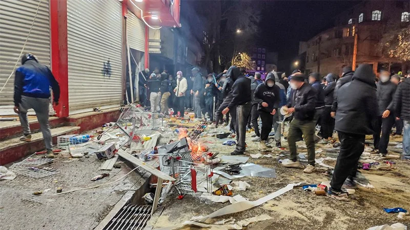
 The world is having the evidence of its eyes all over again that ‘economics drives politics’ and this time around the proof is coming from theocratic Iran. Iranians in their tens of thousands are on the country’s streets calling for a regime change right now but it is all too plain that the wellsprings of the unprecedented revolt against the state are economic in nature. It is widespread financial hardship and currency depreciation, for example, that triggered the uprising in the first place.
However, there is no denying that Iran’s current movement for drastic political change has within its fold multiple other forces, besides the economically affected, that are urging a comprehensive transformation as it were of the country’s political system to enable the equitable empowerment of the people. For example, the call has been gaining ground with increasing intensity over the weeks that the country’s number one theocratic ruler, President Ali Khamenei, steps down from power.
That is, the validity and continuation of theocratic rule is coming to be questioned unprecedentedly and with increasing audibility and boldness by the public. Besides, there is apparently fierce opposition to the concentration of political power at the pinnacle of the Iranian power structure.
Popular revolts have been breaking out every now and then of course in Iran over the years, but the current protest is remarkable for its social diversity and the numbers it has been attracting over the past few weeks. It could be described as a popular revolt in the genuine sense of the phrase. Not to be also forgotten is the number of casualties claimed by the unrest, which stands at some 2000.
Of considerable note is the fact that many Iranian youths have been killed in the revolt. It points to the fact that youth disaffection against the state has been on the rise as well and could be at boiling point. From the viewpoint of future democratic development in Iran, this trend needs to be seen as positive.
Politically-conscious youngsters prioritize self-expression among other fundamental human rights and stifling their channels of self-expression, for example, by shutting down Internet communication links, would be tantamount to suppressing youth aspirations with a heavy hand. It should come as no surprise that they are protesting strongly against the state as well.
Another notable phenomenon is the increasing disaffection among sections of Iran’s women. They too are on the streets in defiance of the authorities. A turning point in this regard was the death of Mahsa Amini in 2022, which apparently befell her all because she defied state orders to be dressed in the Hijab. On that occasion as well, the event brought protesters in considerable numbers onto the streets of Tehran and other cities.
Once again, from the viewpoint of democratic development the increasing participation of Iranian women in popular revolts should be considered thought-provoking. It points to a heightening political consciousness among Iranian women which may not be easy to suppress going forward. It could also mean that paternalism and its related practices and social forms may need to re-assessed by the authorities.
It is entirely a matter for the Iranian people to address the above questions, the neglect of which could prove counter-productive for them, but it is all too clear that a relaxing of authoritarian control over the state and society would win favour among a considerable section of the populace.
However, it is far too early to conclude that Iran is at risk of imploding. This should be seen as quite a distance away in consideration of the fact that the Iranian government is continuing to possess its coercive power. Unless the country’s law enforcement authorities turn against the state as well this coercive capability will remain with Iran’s theocratic rulers and the latter will be in a position to quash popular revolts and continue in power. But the ruling authorities could not afford the luxury of presuming that all will be well at home, going into the future.
Meanwhile US President Donald Trump has assured the Iranian people of his assistance but it is not clear as to what form such support would take and when it would be delivered. The most important way in which the Trump administration could help the Iranian people is by helping in the process of empowering them equitably and this could be primarily achieved only by democratizing the Iranian state.
It is difficult to see the US doing this to even a minor measure under President Trump. This is because the latter’s principal preoccupation is to make the ‘US Great Once again’, and little else. To achieve the latter, the US will be doing battle with its international rivals to climb to the pinnacle of the international political system as the unchallengeable principal power in every conceivable respect.
That is, Realpolitik considerations would be the main ‘stuff and substance’ of US foreign policy with a corresponding downplaying of things that matter for a major democratic power, including the promotion of worldwide democratic development and the rendering of humanitarian assistance where it is most needed. The US’ increasing disengagement from UN development agencies alone proves the latter.
Given the above foreign policy proclivities it is highly unlikely that the Iranian people would be assisted in any substantive way by the Trump administration. On the other hand, the possibility of US military strikes on Iranian military targets in the days ahead cannot be ruled out.
The latter interventions would be seen as necessary by the US to keep the Middle Eastern military balance in favour of Israel. Consequently, any US-initiated peace moves in the real sense of the phrase in the Middle East would need to be ruled out in the foreseeable future. In other words, Middle East peace will remain elusive.
Interestingly, the leadership moves the Trump administration is hoping to make in Venezuela, post-Maduro, reflect glaringly on its foreign policy preoccupations. Apparently, Trump will be preferring to ‘work with’ Delcy Rodriguez, acting President of Venezuela, rather than Maria Corina Machado, the principal opponent of Nicolas Maduro, who helped sustain the opposition to Maduro in the lead-up to the latter’s ouster and clearly the democratic candidate for the position of Venezuelan President.
The latter development could be considered a downgrading of the democratic process and a virtual ‘slap in its face’. While the democratic rights of the Venezuelan people will go disregarded by the US, a comparative ‘strong woman’ will receive the Trump administration’s blessings. She will perhaps be groomed by Trump to protect the US’s security and economic interests in South America, while his administration side-steps the promotion of the democratic empowerment of Venezuelans.

Maharagama today stands at a crossroads. With the emergence of new political leadership, growing public expectations, and the convergence of professional goodwill, the Maharagama Municipal Council (MMC) has been presented with a rare opportunity to redefine the city’s future. At the heart of this moment lies the Silk City (Seda Nagaraya) Initiative (SNI)—a bold yet pragmatic development blueprint designed to transform Maharagama into a modern, vibrant, and economically dynamic urban hub.
This is not merely another urban development proposal. Silk City is a strategic springboard—a comprehensive economic and cultural vision that seeks to reposition Maharagama as Sri Lanka’s foremost textile-driven commercial city, while enhancing livability, employment, and urban dignity for its residents. The Silk City concept represents more than a development plan: it is a comprehensive economic blueprint designed to redefine Maharagama as Sri Lanka’s foremost textile-driven commercial and cultural hub.
A Vision Rooted in Reality
What makes the Silk City Initiative stand apart is its grounding in economic realism. Carefully designed around the geographical, commercial, and social realities of Maharagama, the concept builds on the city’s long-established strengths—particularly its dominance as a textile and retail centre—while addressing modern urban challenges.
The timing could not be more critical. With Mayor Saman Samarakoon assuming leadership at a moment of heightened political goodwill and public anticipation, MMC is uniquely positioned to embark on a transformation of unprecedented scale. Leadership, legitimacy, and opportunity have aligned—a combination that cities rarely experience.
A Voluntary Gift of National Value
In an exceptional and commendable development, the Maharagama Municipal Council has received—entirely free of charge—a comprehensive development proposal titled “Silk City – Seda Nagaraya.” Authored by Deshamanya, Deshashkthi J. M. C. Jayasekera, a distinguished Chartered Accountant and Chairman of the JMC Management Institute, the proposal reflects meticulous research, professional depth, and long-term strategic thinking.
It must be added here that this silk city project has received the political blessings of the Parliamentarians who represented the Maharagama electorate. They are none other than Sunil Kumara Gamage, Minister of Sports and Youth Affairs, Sunil Watagala, Deputy Minister of Public Security and Devananda Suraweera, Member of Parliament.
The blueprint outlines ten integrated sectoral projects, including : A modern city vision, Tourism and cultural city development, Clean and green city initiatives, Religious and ethical city concepts, Garden city aesthetics, Public safety and beautification, Textile and creative industries as the economic core
Together, these elements form a five-year transformation agenda, capable of elevating Maharagama into a model municipal economy and a 24-hour urban hub within the Colombo Metropolitan Region
Why Maharagama, Why Now?
Maharagama’s transformation is not an abstract ambition—it is a logical evolution. Strategically located and commercially vibrant, the city already attracts thousands of shoppers daily. With structured investment, branding, and infrastructure support, Maharagama can evolve into a sleepless commercial destination, a cultural and tourism node, and a magnet for both local and international consumers.
Such a transformation aligns seamlessly with modern urban development models promoted by international development agencies—models that prioritise productivity, employment creation, poverty reduction, and improved quality of life.
Rationale for Transformation
Maharagama has long held a strategic advantage as one of Sri Lanka’s textile and retail centers. With proper planning and investment, this identity can be leveraged to convert the city into a branded urban destination, a sleepless commercial hub, a tourism and cultural attraction, and a vibrant economic engine within the Colombo Metropolitan Region. Such transformation is consistent with modern city development models promoted by international funding agencies that seek to raise local productivity, employment, quality of life, alleviation of urban poverty, attraction and retaining a huge customer base both local and international to the city)
Current Opportunity
The convergence of the following factors make this moment and climate especially critical. Among them the new political leadership with strong public support, availability of a professionally developed concept paper, growing public demand for modernisation, interest among public, private, business community and civil society leaders to contribute, possibility of leveraging traditional strengths (textile industry and commercial vibrancy are notable strengths.
The Silk City initiative therefore represents a timely and strategic window for Maharagama to secure national attention, donor interest and investor confidence.
A Window That Must Not Be Missed
Several factors make this moment decisive: Strong new political leadership with public mandate, Availability of a professionally developed concept, Rising citizen demand for modernization, Willingness of professionals, businesses, and civil society to contribute. The city’s established textile and commercial base
Taken together, these conditions create a strategic window to attract national attention, donor interest, and investor confidence.
But windows close.
Hard Truths: Challenges That Must Be Addressed
Ambition alone will not deliver transformation. The Silk City Initiative demands honest recognition of institutional constraints. MMC currently faces: Limited technical and project management capacity, rigid public-sector regulatory frameworks that slow procurement and partnerships, severe financial limitations, with internal revenues insufficient even for routine operations, the absence of a fully formalised, high-caliber Steering Committee.
Moreover, this is a mega urban project, requiring feasibility studies, impact assessments, bankable proposals, international partnerships, and sustained political and community backing.
A Strategic Roadmap for Leadership
For Mayor Saman Samarakoon, this represents a once-in-a-generation leadership moment. Key strategic actions are essential: 1.Immediate establishment of a credible Steering Committee, drawing expertise from government, private sector, academia, and civil society. 2. Creation of a dedicated Project Management Unit (PMU) with professional specialists. 3. Aggressive mobilisation of external funding, including central government support, international donors, bilateral partners, development banks, and corporate CSR initiatives. 4. Strategic political engagement to secure legitimacy and national backing. 5. Quick-win projects to build public confidence and momentum. 6. A structured communications strategy to brand and promote Silk City nationally and internationally. Firm positioning of textiles and creative industries as the heart of Maharagama’s economic identity
If successfully implemented, Silk City will not only redefine Maharagama’s future but also ensure that the names of those who led this transformation are etched permanently in the civic history of the city.
Voluntary Gift of National Value
Maharagama is intrinsically intertwined with the textile industry. Small scale and domestic textile industry play a pivotal role. Textile industry generates a couple of billion of rupees to the Maharagama City per annum. It is the one and only city that has a sleepless night and this textile hub provides ready-made garments to the entire country. Prices are comparatively cheaper. If this textile industry can be vertically and horizontally developed, a substantial income can be generated thus providing employment to vulnerable segments of employees who are mostly women. Paucity of textile technology and capital investment impede the growth of the industry. If Maharagama can collaborate with the Bombay of India textile industry, there would be an unbelievable transition. How Sri Lanka could pursue this goal. A blueprint for the development of the textile industry for the Maharagama City will be dealt with in a separate article due to time space.
It is achievable if the right structures, leadership commitments and partnerships are put in place without delay.
No municipal council in recent memory has been presented with such a pragmatic, forward-thinking and well-timed proposal. Likewise, few Mayors will ever be positioned as you are today — with the ability to initiate a transformation that will redefine the future of Maharagama for generations. It will not be a difficult task for Saman Samarakoon, Mayor of the MMC to accomplish the onerous tasks contained in the projects, with the acumen and experience he gained from his illustrious as a Commander of the SL Navy with the support of the councilors, Municipal staff and the members of the Parliamentarians and the committed team of the Silk-City Project.
Voluntary Gift of National Value
Maharagama is intrinsically intertwined with the textile industry. The textile industries play a pivotal role. This textile hub provides ready-made garments to the entire country. Prices are comparatively cheaper. If this textile industry can be vertically and horizontally developed, a substantial income can be generated thus providing employment to vulnerable segments of employees who are mostly women.
Paucity of textile technology and capital investment impede the growth of the industry. If Maharagama can collaborate with the Bombay of India textile industry, there would be an unbelievable transition. A blueprint for the development of the textile industry for the Maharagama City will be dealt with in a separate article.
J.A.A.S Ranasinghe
Productivity Specialist and Management Consultant
(The writer can becontacted via Email:rathula49@gmail.com)
Features
Reading our unfinished economic story through Bandula Gunawardena’s ‘IMF Prakeerna Visadum’

Book Review
Why Sri Lanka’s Return to the IMF Demands Deeper Reflection
By mid-2022, the term “economic crisis” ceased to be an abstract concept for most Sri Lankans. It was no longer confined to academic papers, policy briefings, or statistical tables. Instead, it became a lived and deeply personal experience. Fuel queues stretched for kilometres under the burning sun. Cooking gas vanished from household shelves. Essential medicines became difficult—sometimes impossible—to find. Food prices rose relentlessly, pushing basic nutrition beyond the reach of many families, while real incomes steadily eroded.
What had long existed as graphs, ratios, and warning signals in economic reports suddenly entered daily life with unforgiving force. The crisis was no longer something discussed on television panels or debated in Parliament; it was something felt at the kitchen table, at the bus stop, and in hospital corridors.
Amid this social and economic turmoil came another announcement—less dramatic in appearance, but far more consequential in its implications. Sri Lanka would once again seek assistance from the International Monetary Fund (IMF).
The announcement immediately divided public opinion. For some, the IMF represented an unavoidable lifeline—a last resort to stabilise a collapsing economy. For others, it symbolised a loss of economic sovereignty and a painful surrender to external control. Emotions ran high. Debates became polarised. Public discourse quickly hardened into slogans, accusations, and ideological posturing.
Yet beneath the noise, anger, and fear lay a more fundamental question—one that demanded calm reflection rather than emotional reaction:
Why did Sri Lanka have to return to the IMF at all?
This question does not lend itself to simple or comforting answers. It cannot be explained by a single policy mistake, a single government, or a single external shock. Instead, it requires an honest examination of decades of economic decision-making, institutional weaknesses, policy inconsistency, and political avoidance. It requires looking beyond the immediate crisis and asking how Sri Lanka repeatedly reached a point where IMF assistance became the only viable option.
Few recent works attempt this difficult task as seriously and thoughtfully as Dr. Bandula Gunawardena’s IMF Prakeerna Visadum. Rather than offering slogans or seeking easy culprits, the book situates Sri Lanka’s IMF engagement within a broader historical and structural narrative. In doing so, it shifts the debate away from blame and toward understanding—a necessary first step if the country is to ensure that this crisis does not become yet another chapter in a familiar and painful cycle.
Returning to the IMF: Accident or Inevitability?
The central argument of IMF Prakeerna Visadum is at once simple and deeply unsettling. It challenges a comforting narrative that has gained popularity in times of crisis and replaces it with a far more demanding truth:
Sri Lanka’s economic crisis was not created by the IMF.
IMF intervention became inevitable because Sri Lanka avoided structural reform for far too long.
This framing fundamentally alters the terms of the national debate. It shifts attention away from external blame and towards internal responsibility. Instead of asking whether the IMF is good or bad, Dr. Gunawardena asks a more difficult and more important question: what kind of economy repeatedly drives itself to a point where IMF assistance becomes unavoidable?
The book refuses the two easy positions that dominate public discussion. It neither defends the IMF uncritically as a benevolent saviour nor demonises it as the architect of Sri Lanka’s suffering. Instead, IMF intervention is placed within a broader historical and structural context—one shaped primarily by domestic policy choices, institutional weaknesses, and political avoidance.
Public discourse often portrays IMF programmes as the starting point of economic hardship. Dr. Gunawardena corrects this misconception by restoring the correct chronology—an essential step for any honest assessment of the crisis.
The IMF did not arrive at the beginning of Sri Lanka’s collapse.
It arrived after the collapse had already begun.
By the time negotiations commenced, Sri Lanka had exhausted its foreign exchange reserves, lost access to international capital markets, officially defaulted on its external debt, and entered a phase of runaway inflation and acute shortages.
Fuel queues, shortages of essential medicines, and scarcities of basic food items were not the product of IMF conditionality. They were the direct outcome of prolonged foreign-exchange depletion combined with years of policy mismanagement. Import restrictions were imposed not because the IMF demanded them, but because the country simply could not pay its bills.
From this perspective, the IMF programme did not introduce austerity into a functioning economy. It formalised an adjustment that had already become unavoidable. The economy was already contracting, consumption was already constrained, and living standards were already falling. The IMF framework sought to impose order, sequencing, and credibility on a collapse that was already under way.
Seen through this lens, the return to the IMF was not a freely chosen policy option, but the end result of years of postponed decisions and missed opportunities.
A Long IMF Relationship, Short National Memory
Sri Lanka’s engagement with the IMF is neither new nor exceptional. For decades, governments of all political persuasions have turned to the Fund whenever balance-of-payments pressures became acute. Each engagement was presented as a temporary rescue—an extraordinary response to an unusual storm.
Yet, as Dr. Gunawardena meticulously documents, the storms were not unusual. What was striking was not the frequency of crises, but the remarkable consistency of their underlying causes.
Fiscal indiscipline persisted even during periods of growth. Government revenue remained structurally weak. Public debt expanded rapidly, often financing recurrent expenditure rather than productive investment. Meanwhile, the external sector failed to generate sufficient foreign exchange to sustain a consumption-led growth model.
IMF programmes brought temporary stability. Inflation eased. Reserves stabilised. Growth resumed. But once external pressure diminished, reform momentum faded. Political priorities shifted. Structural weaknesses quietly re-emerged.
This recurring pattern—crisis, adjustment, partial compliance, and relapse—became a defining feature of Sri Lanka’s economic management. The most recent crisis differed only in scale. This time, there was no room left to postpone adjustment.
Fiscal Fragility: The Core of the Crisis
A central focus of IMF Prakeerna Visadum is Sri Lanka’s chronically weak fiscal structure. Despite relatively strong social indicators and a capable administrative state, government revenue as a share of GDP remained exceptionally low.
Frequent tax changes, politically motivated exemptions, and weak enforcement steadily eroded the tax base. Instead of building a stable revenue system, governments relied increasingly on borrowing—both domestic and external.
Much of this borrowing financed subsidies, transfers, and public sector wages rather than productivity-enhancing investment. Over time, debt servicing crowded out development spending, shrinking fiscal space.
Fiscal reform failed not because it was technically impossible, Dr. Gunawardena argues, but because it was politically inconvenient. The costs were immediate and visible; the benefits long-term and diffuse. The eventual debt default was therefore not a surprise, but a delayed consequence.
The External Sector Trap
Sri Lanka’s narrow export base—apparel, tea, tourism, and remittances—generated foreign exchange but masked deeper weaknesses. Export diversification stagnated. Industrial upgrading lagged. Integration into global value chains remained limited.
Meanwhile, import-intensive consumption expanded. When external shocks arrived—global crises, pandemics, commodity price spikes—the economy had little resilience.
Exchange-rate flexibility alone cannot generate exports. Trade liberalisation without an industrial strategy redistributes pain rather than creates growth.
Monetary Policy and the Cost of Lost Credibility
Prolonged monetary accommodation, often driven by political pressure, fuelled inflation, depleted reserves, and eroded confidence. Once credibility was lost, restoring it required painful adjustment.
Macroeconomic credibility, Dr. Gunawardena reminds us, is a national asset. Once squandered, it is extraordinarily expensive to rebuild.
IMF Conditionality: Stabilisation Without Development?
IMF programmes stabilise economies, but they do not automatically deliver inclusive growth. In Sri Lanka, adjustment raised living costs and reduced real incomes. Social safety nets expanded, but gaps persisted.
This raises a critical question: can stabilisation succeed politically if it fails socially?
Political Economy: The Missing Middle
Reforms collided repeatedly with electoral incentives and patronage networks. IMF programmes exposed contradictions but could not resolve them. Without domestic ownership, reform risks becoming compliance rather than transformation.
Beyond Blame: A Diagnostic Moment
The book’s greatest strength lies in its refusal to engage in blame politics. IMF intervention is treated as a diagnostic signal, not a cause—a warning light illuminating unresolved structural failures.
The real challenge is not exiting an IMF programme, but exiting the cycle that makes IMF programmes inevitable.
A Strong Public Appeal: Why This Book Must Be Read
This is not an anti-IMF book.
It is not a pro-IMF book.
It is a pro-Sri Lanka book.
Published by Sarasaviya Publishers, IMF Prakeerna Visadum equips readers not with anger, but with clarity—offering history, evidence, and honest reflection when the country needs them most.
Conclusion: Will We Learn This Time?
The IMF can stabilise an economy.
It cannot build institutions.
It cannot create competitiveness.
It cannot deliver inclusive development.
Those responsibilities remain domestic.
The question before Sri Lanka is simple but profound:
Will we repeat the cycle, or finally learn the lesson?
The answer does not lie in Washington.
It lies with us.
By Professor Ranjith Bandara
Emeritus Professor, University of Colombo

Let’s build a new Sri Lanka upholding harmony, mutual respect by protecting the religious and cultural rights of others- PM

Ambassador of the United States of America to Sri Lanka pays farewell call on PM

Bangladesh cricketers threaten boycott unless BCB director Nazmul Islam resigns

Mitchell upstages Rahul as New Zealand level series

Shafali Verma, Lizelle Lee hand Delhi Capitals first win in thriller

Fair weather will prevail except for evening showers in the Kaluthara, Galle, Matara and Rathnapura districts

‘Dates have the highest sugar content to fight Coronavirus’

Sunday Island 27 December – Headlines

#SundayIsland 17th December – Headlines

Sunday Island – 28th March

Sunday Island Headlines – 21 March

Sunday Island – 21st February – Headlines
-

 Business4 days ago
Dialog and UnionPay International Join Forces to Elevate Sri Lanka’s Digital Payment Landscape
-
 News4 days ago
Sajith: Ashoka Chakra replaces Dharmachakra in Buddhism textbook
-

 Features4 days ago
The Paradox of Trump Power: Contested Authoritarian at Home, Uncontested Bully Abroad
-

 Features4 days ago
Subject:Whatever happened to (my) three million dollars?
-

 News4 days ago
Level I landslide early warnings issued to the Districts of Badulla, Kandy, Matale and Nuwara-Eliya extended
-

 Business1 day ago
New policy framework for stock market deposits seen as a boon for companies
-

 Opinion6 days ago
The minstrel monk and Rafiki, the old mandrill in The Lion King – II
-

 News4 days ago
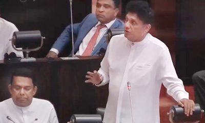
65 withdrawn cases re-filed by Govt, PM tells Parliament