Features
How to gamble with floods
by Eng. Mahinda Panapitiya and
Eng. Wasantha Lal (PhD)
(Two residents from Attanagalu Oya Basin)
Introduction
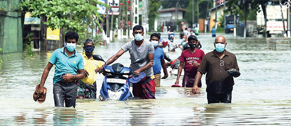
Flooding during heavy rains and water pollution during normal time in natural streams is a common problem all over the world when human settlements are located near flood prone areas. For example, about 7-10% land area, in the US, under human settlements, are prone to flooding. In ancient cultures, flooding was perceived as a blessing in disguise because it was the main transportation method of fertilisers, free of charge, for agriculture activities in temporary submergence areas called flood plains. After moving people into flood plains because of shortage of space for settlement, floods have become a curse for humans. Deciding to settle down in flood prone area is a gamble. However, there are modern technologies called flood modelling available for us to overcome this problem.
Flood Modelling
For an example, it is now possible to simulate different flood conditions that may arise due to heavy rains, before it actually occurs, using satellite and survey data. This is called “modelling” in engineering. Any area prone to floods can be modelled and divided into zones so that land users will know in advance how deep their lands will get submerged. This type of performance-based methods also evaluates how an existing or newly introduced flood mitigation effort, performs under different flooding events.
Hidden reasons behind frequent flooding and water pollution of natural streams
 * Unplanned real estate development by clearing local tree cover resulting in impervious areas (roofs, carpeted roads, etc.,) prevents water infiltrating the soil. This increases the runoff rate, causing flash floods during heavy rains. On the other hand, during droughts, all the natural tributary streams and wells in those areas dry up soon after the rain. This is very common in basin such as the Attanagalu Oya.
* The obstruction of natural stream and their tributaries due to poor maintenance. This is very common along the Kelani River basin
* Illicit encroachment causes the filling of wetlands in the flood plains. As a result, rain water has no designated place to collect before flowing out gradually. Most of the floods in Gampaha, Ja-ela and Wattala are due to this issue.
* Deposition of sediments washed down from upland areas due to lack of tree cover and also the erosion of stream banks whose reservations are encroached on either for agriculture in rural areas or for settlement in urban areas
* Inadequate flow capacity in local streams due to invasive weed growth associated with polluted water and lack of riparian tree cover. (Wattala)
* Lack of awareness among officials who manage water resources in natural streams about the role of riverine environments in flood plains which act as kidneys in our ecosystem while preventing flash floods.
How the community could face these challenges
Those who are already living in flood-prone areas or are planning to do so should be aware of the different risk levels in the areas concerned. For that, there is a need to do an exercise called Flood Hazard Zoning, This approach is very common in the developed world. This exercise will also enhance the community participation for government intervention such as canal cleaning and discouraging further encroachment on flood plains by land fillings.
Available Technologies
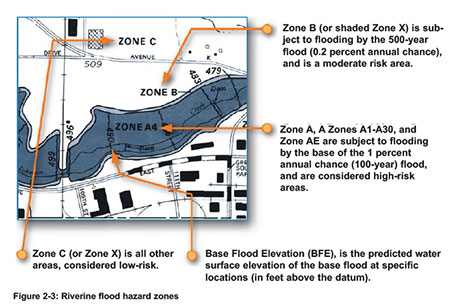
A sketch above extracted from a technical guideline adapted in the US shows a typical flood zoning map, which could be used by a community to decide whether they should or should not build houses in a particular location.
For example, in this map, people who are in Zone A are in a high-risk area subject to flooding. Zone C is a low risk area. A person who wants to build a house in Zone A, which is designated as “100 Year Flood Zone”, will have a 26% chance his house being submerged once in 30 years, which is the normal bank lending period of a housing loan. For the next 70 years, which is the normal lifetime of a building, the chance of being flooded is 50%. For a person who wants to build a house in Zone B designated as “500 Year Flood Zone” will have 18% chance of his residence being submerged once in 70 years. By knowing in advance through these flood zoning maps, people themselves become aware of flood danger before it occurs and, therefore, they prepare themselves for the challenges during flood situations. When there is no such initial warnings, governments will have to bear the whole responsibility.
This type of mapping would also be a useful guide for land valuation as well as for insurances against flood risks. With flood zoning, flood insurance becomes an option that adds a financial component in designing buildings to address those future risks. For example, people can build their houses at elevated levels on columns to suit predicted flood levels. Also the sewerage systems can be introduced to suit the wetland environments.
Lessons from the US
Every state in the US is required by law (water policy) to demonstrate that (a) the public is protected from floods; (b) the public has sufficient water available for drinking and farmin, etc. (d) there is enough water to support the environment. Computer models simulating the year-round hydrology are used for the purpose.  Those models show how water from the rains could be saved for use during the dry season. Government agencies in the US do not use the models currently in use in Sri Lanka. They have developed their own models to simulate flooding. Models used in Sri Lanka are bought primarily from two European countries. They are normally used only to study individual flood events. The fundamental ideas used in these models have not changed since 1980s in Sri Lanka, and these models are still sold primarily to developing countries like Sri Lanka. On the other hand, teams of senior engineers are employed for developing those models used in the US, before permits are issued for new development projects. There are also Sri Lankans engineers among those teams in the US, as primary developers.
Opposite of flood
Wetlands of flood plain are the interface between aquatic and terrestrial areas. Plants in those wetlands play a very vital role in cleaning water biologically before it falls into the main streams. Wetlands are in fact the kidneys of ecosystems. Over the years, due to the so-called development, the environmental features of flood plains have undergone changes, causing not only floods during heavy rains but also malfunctioning natural water cleaning process, especially during droughts.
Note that those new technologies address not only flood situations but also help face drought situations, too, by identifying areas suitable for temporary water storages within flood plains. For example, during a previous drought situation there was a water shortage in the Attanagalu Oya basin, and the people had to purchase water from trucks, though annually the Oya releases into the sea a volume of water equal to that of the Parakrama Samudraya! Severe drought situations are even worse than floods, especially in view of the current pollution levels of natural streams bordering urban areas. To address this issue also, technologies could be used to identify naturally available water cleaning wetlands to be preserved.
King Parakramabahu’s famous quote about water conservation and utilization—“Do not release even a drop of rain water to the sea without using”—applies not only to our dry zone but also to the west zone.


It is also different from all past governments as it faces new and different challenges
No one knows whether the already broken ceasefire between the US and Iran, with Israel as a reluctant adjunct, will last the full 10 days, or what will come thereafter. The world’s economic woes are not over and the markets are yo-yoing in response to Trump’s twitches and Iran’s gate keeping at the Strait of Hormuz. The gloomy expert foretelling is that full economic normalcy will not return until the year is over even if the war were to end with the ceasefire. That means continuing challenges for Sri Lanka and more of the tough learning in the art of governing for the NPP.
The NPP government has been doing what most governments in Asia have been doing to cope with the current global crisis, which is also an Asian crisis insofar as oil supplies and other supply chains are concerned. What the government can and must do additionally is to be totally candid with the people and keep them informed of everything that it is doing – from monitoring import prices to the timely arranging of supplies, all the details of tender, the tracking of arrivals, and keeping the distribution flow through the market without bottlenecks. That way the government can eliminate upstream tender rackets and downstream hoarding swindles. People do not expect miracles from their government, only honest, sincere and serious effort in difficult circumstances. Backed up by clear communication and constant public engagement.
But nothing is going to stop the flow of criticisms against the NPP government. That is a fact of Sri Lankan politics. Even though the opposition forces are weak and have little traction and even less credibility, there has not been any drought in the criticisms levelled against the still fledgling government. These criticisms can be categorized as ideological, institutional and oppositional criticisms, with each category having its own constituency and/or commentators. The three categories invariably overlap and there are instances of criticisms that excite only the pundits but have no political resonance.
April 5 anniversary nostalgia
There is also a new line of criticism that might be inspired by the April 5 anniversary nostalgia for the 1971 JVP insurrection. This new line traces the NPP government to the distant roots of the JVP – its April 1965 founding “in a working-class home in Akmeemana, Galle” by a 22-year old Rohana Wijeweera and seven others; the short lived 1971 insurrection that was easily defeated; and the much longer and more devastating second (1987 to 1989) insurrection that led to the elimination of the JVP’s frontline leaders including Wijeweera, and brought about a change in the JVP’s political direction with commitment to parliamentary democracy. So far, so good, as history goes.
But where the nostalgic narrative starts to bend is in attempting a straight line connection from the 1965 Akmeemana origins of the JVP to the national electoral victories of the NPP in 2024. And the bend gets broken in trying to bridge the gap between the “founding anti-imperialist economics” of the JVP and the practical imperatives of the NPP government in “governing a debt-laden small open economy.” Yet this line of criticism differs from the other lines of criticism that I have alluded to, but more so for its moral purpose than for its analytical clarity. The search for clarity could begin with question – why is the NPP government more than a JVP offspring? The answer is not so simple, but it is also not too complicated.
For starters, the JVP was a political response to the national and global conditions of the 1960s and 1970s, piggybacking socialism on the bandwagon of ethno-nationalism in a bi-polar world that was ideologically split between status quo capitalism and the alternative of socialism. The NPP government, on the other hand, is not only a response to, but is also a product of the conditions of the 2010s and 2020s. The twain cannot be more different. Nothing is the same between then and now, locally and globally.
A pragmatic way to look at the differences between the origins of the JVP and the circumstances of the NPP government is to look at the very range of criticisms that are levelled against the NPP government. What I categorize as ideological criticisms include criticisms of the government’s pro-IMF and allegedly neo-liberal economic policies, as well as the government’s foreign policy stances – on Israel, on the current US-Israel war against Iran, the geopolitics of the Indian Ocean, and the apparent closeness to the Modi government in India. These criticisms emanate from the non-JVP left and Sinhala Buddhist nationalists.
Strands of nationalism
To digress briefly, there are several strands in the overall bundle of Sri Lankan nationalism. There is the liberal inclusive strand, the left-progressive strand, the exclusive Sinhala Buddhist Nationalist (SBN) strand, and the defensive strands of minority nationalisms. Given Sri Lanka’s historical political formations and alliances, much overlapping goes on between the different strands. The overlapping gets selective on an issue by issue basis, which in itself is not unwelcome insofar as it promotes plurality in place of exclusivity.
Historically as well, and certainly after 1956, the SBN strand has been the dominant strand of nationalism in Sri Lanka and has had the most influential say in every government until now. Past versions of the JVP frequently straddled the dominant SBN space. Currently, however, the dominant SBN strand is in one of its more dormant phases and the NPP government could be a reason for the current dormancy. This is an obvious difference between the old JVP and the new NPP.
A second set of criticisms, or institutional criticisms, emanate from political liberals and human rights activists and these are about the NPP government’s actions or non-actions in regard to constitutional changes, the future of the elected executive presidency, the status of provincial devolution and the timing of provincial council elections, progress on human rights issues, the resolution of unfinished postwar businesses including the amnesia over mass graves. These criticisms and the issues they represent are also in varying ways the primary concerns of the island’s Tamils, Muslims and the Malaiyaka (planntationn) Tamils. As with the overlapping between the left and the non-minority nationalists, there is also overlapping between the liberal activists and minority representatives.
A third category includes what might be called oppositional criticisms and they counterpose the JVP’s past against the NPP’s present, call into question the JVP’s commitment to multi-party democracy and raise alarms about a creeping constitutional dictatorship. This category also includes criticisms of the NPP government’s lack of governmental experience and competence; alleged instances of abuse of power, mismanagement and even corruption; alleged harassment of past politicians; and the failure to find the alleged mastermind behind the 2019 Easter bombings. At a policy and implementational level, there have been criticisms of the government’s educational reforms and electricity reforms, the responses to cyclone Ditwah, and the current global oil and economic crises. The purveyors of oppositional criticisms are drawn from the general political class which includes political parties, current and past parliamentarians, as well as media pundits.
Criticisms as expectations
What is common to all three categories of criticisms is that they collectively represent what were understood to be promises by the NPP before the elections, and have become expectations of the NPP government after the elections. It is the range and nature of these criticisms and the corresponding expectations that make the NPP government a lot more than a mere JVP offspring, and significantly differentiate it from every previous government.
The deliverables that are expected of the NPP government were never a part of the vocabulary of the original JVP platform and programs. The very mode of parliamentary politics was ideologically anathema to the JVP of Akmeemana. And there was no mention of or concern for minority rights, or constitutional reforms. On foreign policy, it was all India phobia without Anglo mania – a halfway variation of Sri Lanka’s mainstream foreign policy of Anglo mania and India phobia. For a party of the rural proletariat, the JVP was virulently opposed to the plantation proletariat. The JVP’s version of anti-imperialist economics would hardly have excited the Sri Lankan electorate at any time, and certainly not at the present time.
At the same time, the NPP government is also the only government that has genealogical antecedents to a political movement or organization like the JVP. That in itself makes the NPP government unique among Sri Lanka’s other governments. The formation of the NPP is the culmination of the evolution of the JVP that began after the second insurrection with the shedding of political violence, acceptance of political plurality and commitment to electoral democracy.
But the evolution was not entirely a process of internal transformation. It was also a response to a rapidly and radically changing circumstances both within Sri Lanka and beyond. This evolution has not been a rejection of the founding socialist purposes of the JVP in 1968, but their adaptation in the endless political search, under constantly changing conditions, for a non-violent, socialist and democratic framework that would facilitate the full development of the human potential of all Sri Lankans.
The burden of expectations is unmistakable, but what is also remarkable is their comprehensiveness and the NPP’s formal commitment to all of them at the same time. No previous government shouldered such an extensive burden or showed such a willing commitment to each and every one of the expectations. In the brewing global economic crisis, the criticisms, expectations and the priorities of the government will invariably be focussed on keeping the economy alive and alleviating the day-to-day difficulties of millions of Sri Lankan families. While what the NPP government can and must do may not differ much from what other Asian governments – from Pakistan to Vietnam – are doing, it could and should do better than what any and all past Sri Lankan governments did when facing economic challenges.
by Rajan Philips

After threatening to annihilate one of the planet’s oldest civilizations, TACO* Trump chickened out again by grasping the ceasefire lifeline that Pakistan had assiduously prepared. Trump needed the ceasefire badly to stem the mounting opposition to the war in America. Israeli Prime Minister Netanyahu wanted the war to continue because he needed it badly for his political survival. So, he contrived a fiction and convinced Trump that Lebanon is not included in the ceasefire. Trump as usual may not have noticed that Pakistan’s Prime Minister Shehbaz Shariff had clearly indicated Lebanon’s inclusion in his announcement of the ceasefire at 7:50 PM, Tuesday, on X. Ten minutes before Donald Trump’s fake deadline.
True to form on Wednesday, Israel unleashed the heaviest assault by far on Lebanon, reportedly killing over 300 people, the highest single-day death toll in the current war. Iran responded by re-closing the Strait of Hormuz and questioning the need for talks in Islamabad over the weekend. There were other incidents as well, with an oil refinery attacked in Iran, and Iranian drones and missiles slamming oil and gas infrastructure in UAE, Saudi Arabia, Bahrain and Qatar.
The US tried to insist that Lebanon is not part of the ceasefire, with the argumentative US Vice President JD Vance, who was in Budapest, Hungary, campaigning for Viktor Orban, calling the whole thing a matter of “bad faith negotiation” as well as “legitimate misunderstanding” on the part of Iran, and warning Iran that “it would be dumb to jeopardise its ceasefire with Washington over Israel’s attacks in Lebanon.”
But as the attack in Lebanon drew international condemnation – from Pope Leo to UN Secretary General António Guterres, and several world leaders, and amidst fears of Lebanon becoming another Gaza with 1,500 people including 130 children killed and more than a million people displaced, Washington got Israel to stop its “lawn mowing” in southern Lebanon.
Prime Minister Benjamin Netanyahu agreed to “open direct negotiations with Lebanon as soon as possible,”. Lebanese President Joeseph Aoun has also called for “a ceasefire between Israel and Lebanon, followed by direct negotiations between them.” Israel’s involvement in Lebanon remains a wild card that threatens the ceasefire and could scuttle the talks between the US and Iran scheduled for Saturday in Islamabad.
Losers and Winners
After the ceasefire, both the Trump Administration and Iran have claimed total victories while the Israeli government wants the war to continue. The truth is that after more than a month into nonstop bombing of Iran, America and Israel have won nothing. Only Iran has won something it did not have when Trump and Netanyahu started their war. Iran now has not only a say over but control of the Strait of Hormuz. The ceasefire acknowledges this. Both Trump and Netanyahu are under fire in their respective countries and have no allies in the world except one another.
The real diplomatic winner is Pakistan. Salman Rushdie’s palimpsest-country has emerged as a key player in global politics and an influential mediator in a volatile region. Pakistan’s Prime Minister Shehbaz Sharif and Chief of Defence Field Marshal Asim Munir have both been praised by President Trump and credited for achieving the current ceasefire. The Iranian regime has also been effusive in its praise of Pakistan’s efforts.
It is Pakistan that persisted with the effort after initial attempts at backdoor diplomacy by Egypt, Pakistan and Türkiye started floundering. Sharing a 900 km border and deep cultural history with Iran, and having a skirmish of its own on the eastern front with Afghanistan, Pakistan has all the reason to contain and potentially resolve the current conflict in Iran. Although a majority Sunni Muslim country, Pakistan is home to the second largest Shia Muslim population after Iran, and is the easterly terminus of the Shia Arc that stretches from Lebanon. The country also has a mutual defense pact with Saudi Arabia that includes Pakistan’s nuclear cover for the Kingdom. An open conflict between Iran and Saudi Arabia would have put Pakistan in a dangerously awkward position.
It is now known and Trump has acknowledged that China had a hand in helping Iran get to the diplomatic table. Pakistan used its connections well to get Chinese diplomatic reinforcement. Pakistani Foreign Minister Ishaq Dar flew to Beijing to brief his Chinese counterpart and secured China’s public support for the diplomatic efforts. The visit produced a Five-Point Plan that became a sequel to America’s 15-point proposal and the eventual ten-point offer by Iran.
There is no consensus between parties as to which points are where and who is agreeing to what. The chaos is par for the course the way Donald Trumps conducts global affairs. So, all kudos to Pakistan for quietly persisting with old school toing and froing and producing a semblance of an agreement on a tweet without a parchment.
It is also noteworthy that Israel has been excluded from all the diplomatic efforts so far. And it is remarkable, but should not be surprising, the way Trump has sidelined Isreal from the talks. Prime Minister Netanyahu has been enjoying overwhelming support of Israelis for starting the war of his life against Iran and getting the US to spearhead it. But now the country is getting confused and is exposed to Iranian missiles and drones far more than ever before. The Israeli opposition is finally coming alive realizing what little has Netanyahu’s wars have achieved and at what cost. Israel has alienated a majority of Americans and has no ally anywhere else.
It will be a busy Saturday in Islamabad, where the US and Iranian delegations are set to meet. Iran would seem to have insisted and secured the assurance that the US delegation will be led by Vice President Vance, while including Trump’s personal diplomats – Steve Witkoff and son-in-law Jared Kushner. Iran has not announced its team but it is expected to be led, for protocol parity, by Iran’s Speaker Mohammad Bagher Ghalibaf, and will likely include its suave Foreign Minister Abbas Araghchi. Vice President Vance’s attendance will be the most senior US engagement with Iran since Secretary of State John Kerry negotiated the 2015 nuclear deal under President Obama.
The physical arrangements for the talks are still not public although Islamabad has been turned into a security fortress given the stakes and risks involved. The talks are expected to be ‘indirect’, with the two delegations in separate rooms and Pakistani officials shuttling between them. The status of Iran’s enriched uranium and the reopening of the Strait of Hormuz will be the major points of contention. After Netanyahu’s overreach on Wednesday, Lebanon is also on the short list
The 2015 nuclear deal (the Joint Comprehensive Action Plan) took months of negotiations and involved multiple parties besides the US and Iran, including China, France, Germany, UK, Russia and the EU. That served the cause of regional and world peace well until Trump tore up the deal to spite Obama. It would be too much to expect anything similar after a weekend encounter in Islamabad. But if the talks could lead to at least a permanent ceasefire and the return to diplomacy that would be a huge achievement.
(*As of 2025–2026, Donald Trump is nicknamed “TACO Trump” by Wall Street traders and investors as an acronym for “”. This term highlights a perceived pattern of him making strong tariff threats that cause market panic, only to later retreat or weaken them, causing a rebound.)
by Rajan Philips

We are passing through the ten-day interregnum called a ceasefire over the War on Iran. The world may breathe briefly, but this pause is not reassurance—it is a deliberate interlude, a vacuum in which every actor positions for the next escalation. Iran is far from secure. Behind the veneer of calm, external powers and local forces are preparing, arming, and coordinating. The United States is unlikely to deploy conventional ground troops; the next moves will be executed through proxies whose behaviour will defy expectation. These insurgents are shaped, guided, and amplified by intelligence and technology, capable of moving silently, striking precisely, and vanishing before retaliation. The ceasefire is not peace—it is the prelude to disruption.
The Kurds, historically instruments of Tehran against Baghdad, are now vectors for the next insurgency inside Iran. This movement is neither organic nor local. It is externally orchestrated, with the CIA as the principal architect. History provides the blueprint: under Mohammad-Reza Shah Pahlavi, Kurdish uprisings were manipulated, never supported out of sympathy. They were instruments of leverage against Iraq, a way to weaken a rival while projecting influence beyond Iran’s borders. Colonel Isa Pejman, Iranian military intelligence officer who played a role in Kurdish affairs, recalled proposing support for a military insurgency in Iraq, only for the Shah to respond coldly: “[Mustafa] Barzani killed my Army soldiers… please forget it. The zeitgeist and regional context have been completely transformed.” The Kurds were pawns, but pawns with strategic weight. Pejman later noted: “When the Shah wrote on the back of the letter ‘Accepted’ to General Pakravan, I felt I was the true leader of the Kurdish movement.” The seeds planted then are now being activated under new, technologically empowered auspices.
Iran’s geographic vulnerabilities make this possible. The Shah understood the trap: a vast territory with porous borders, squeezed by Soviet pressure from the north and radical Arab states from the west. “We are in a really terrible situation since Moscow’s twin pincers coming down through Kabul and Baghdad surround us,” he warned Asadollah Alam. From Soviet support for the Mahabad Republic to Barzani’s dream of a unified Kurdistan, Tehran knew an autonomous Kurdish bloc could destabilize both Iraq and Iran. “Since the formation of the Soviet-backed Mahabad Republic, the Shah had been considerably worried about the Kurdish threat,” a US assessment concluded.
Today, the Kurds’ significance is operational, not symbolic. The CIA’s recent rescue of a downed F-15 airman using Ghost Murmur, a quantum magnetometry system, demonstrated the reach of technology in intelligence operations. The airman survived two days on Iranian soil before extraction. This was not a simple rescue; it was proof that highly mobile, technologically augmented operations can penetrate Iranian territory with surgical precision. The same logic applies to insurgency preparation: when individuals can be tracked through electromagnetic signatures, AI-enhanced surveillance, and drones, proxy forces can be armed, guided, and coordinated with unprecedented efficiency. The Kurds are no longer pawns—they are a living network capable of fracturing Iranian cohesion while providing deniability to foreign powers.
Iran’s engagement with Iraqi Kurds was always containment, not empowerment. The Shah’s goal was never Kurdish independence. “We do not approve an independent [Iraqi] Kurdistan,” he stated explicitly. Yet their utility as instruments of regional strategy was undeniable. The CIA’s revival of these networks continues a long-standing pattern: insurgent groups integrated into the wider calculus of international power. Israel, Iran, and the Kurds formed a triangular strategic relationship that terrified Baghdad. “For Baghdad, an Iranian-Israeli-Kurdish triangular alliance was an existential threat,” contemporary reports noted. This is the template for modern manipulation: a networked insurgency, externally supported, capable of destabilizing regimes from within while giving foreign powers plausible deniability.
Iran today faces fragility. Years of sanctions, repression, and targeted strikes have weakened educational and scientific hubs; Sharif University in Tehran, one of the country’s leading scientific centres, was bombed. Leaders, scholars, and innovators have been eliminated. Military readiness is compromised. Generations-long setbacks leave Iran exposed. Against this backdrop, a Kurdish insurgency armed with drones, AI-supported surveillance, and precision munitions could do more than disrupt—it could fracture the state internally. The current ten-day ceasefire is a mirage; the next wave of revolt is already being orchestrated.
CIA involvement is deliberate. Operations are coordinated with allied intelligence agencies, leveraging Kurdish grievances, mobility, and ethnolinguistic networks. The Kurds’ spread across Iran, Iraq, Turkey, and Syria provides operational depth—allowing insurgents to strike, vanish, and regroup with impunity. Barzani understood leverage decades ago: “We could be useful to the United States… Look at our strategic location on the flank of any possible Soviet advance into the Middle East.” Today, the calculation is inverted: Kurds are no longer instruments against Baghdad; they are potential disruptors inside Tehran itself.
Technology is central. Ghost Murmur’s ability to detect a single heartbeat remotely exemplifies how intelligence can underpin insurgent networks. Drones, satellite communications, AI predictive modeling, and battlefield sensors create an infrastructure that can transform a dispersed Kurdish insurgency into a high-precision operation. Iran can no longer rely on fortifications or loyalty alone; the external environment has been recalibrated by technology.
History provides the roadmap. The Shah’s betrayal of Barzani after the 1975 Algiers Agreement demonstrated that external actors can manipulate both Iranian ambitions and Kurdish loyalties. “The Shah sold out the Kurds,” Yitzhak Rabin told Kissinger. “We could not station our troops there and keep fighting forever,” the Shah explained to Alam. The Kurds are a pivot, not a cause. Networks once acting under Tehran’s influence are now being repurposed against it.
The insurgency exploits societal fissures. Kurdish discontent in Iran, suppressed for decades, provides fertile ground. Historical betrayal fuels modern narratives: “Barzani claimed that ‘Isa Pejman sold us out to the Shah and the Shah sold us out to the US.’” Intelligence agencies weaponize these grievances, pairing them with training, technological augmentation, and covert support.
Geopolitically, the stakes are immense. The Shah’s defensive-offensive doctrine projected Iranian influence outward to neutralize threats. Today, the logic is inverted: the same networks used to contain Iraq are being readied to contain Iran. A technologically augmented Kurdish insurgency, covertly backed, could achieve in months what decades of sanctions, diplomacy, or repression have failed to accomplish.
The operation will be asymmetric, high-tech, and dispersed. UAVs, quantum-enhanced surveillance, encrypted communications, and AI-directed logistics will dominate. Conventional Iranian forces are vulnerable to this type of warfare. As Pejman reflected decades ago, “Our Army was fighting there, rather than the Kurds who were harshly defeated… How could we keep such a place?” Today, the challenge is magnified by intelligence superiority on the insurgents’ side.
This is not a temporary flare-up. The CIA and its allies are constructing a generational network of influence. Experience from Iraq, Syria, and Lebanon proves these networks endure once operationalised. The Shah recognized this: “Iran’s non-state foreign policy under the Shah’s reign left a lasting legacy for the post-Revolution era.” Today, those instruments are being remade as vectors of foreign influence inside Iran.
The future is stark. Iran faces not simply external threats, but a carefully engineered insurgency exploiting historical grievances, technological superiority, and precise intelligence. The Kurds are central. History, technology, and geopolitical calculation converge to create a transformative threat. Tehran’s miscalculations, betrayals, and suppressed grievances now form the lattice for this insurgency. The Kurds are positioned not just as an ethnic minority, but as a vector of international strategy—Tehran may be powerless to stop it.
Iran’s containment strategies have been weaponized, fused with technology, and inverted against it. The ghosts of Barzani’s Peshmerga, the shadows of Algiers, and the Shah’s strategic vision now converge with Ghost Murmur, drones, and AI. Tehran faces a paradox: the instruments it once controlled are now calibrated to undermine its authority. The next Kurdish revolt will not only fight in the mountains but in the electromagnetic shadows where intelligence operates, consequences are lethal, and visibility is scarce.
by Nilantha Ilangamuwa

Pakistani army chief in Tehran amid bid to restart US talks

Sri Lanka repatriates 238 Iranian sailors stranded after US torpedo attack

Indonesian Navy Sailing Ship KRI BIMA SUCI – 945 makes port call in Colombo

PM initiates children into learning at the auspicious time while observing New Year traditional customs and rituals

Navy seize an Indian fishing boat poaching in seas north of Mannar

PNS TAIMUR & ASLAT set sail from Colombo

‘Dates have the highest sugar content to fight Coronavirus’

Sunday Island 27 December – Headlines

#SundayIsland 17th December – Headlines

Sunday Island – 28th March

Sunday Island Headlines – 21 March

Sunday Island – 21st February – Headlines
-

 News4 days ago
CEB orders temporary shutdown of large rooftop solar systems
-

 News7 days ago
AG: Coal procurement full of irregularities
-

 Business6 days ago
Israeli attack on Lebanon triggers local stock market volatility
-

 Features4 days ago
From Royal College Platoon to National Cadet Corps: 145 years of discipline, leadership, and modern challenges
-

 Business7 days ago
Hayleys Mobility introduces Premium OMODA C9 PHEV
-

 Business6 days ago
HNB Assurance marks 25 years with strategic transformation to ‘HNB Life’
-

 Latest News3 days ago
PNS TAIMUR & ASLAT arrive in Colombo
-

 Sports7 days ago
DS to face St. Anthony’s in ‘Bridges of Brotherhood’ cricket encounter