Weather
Fairly heavy showers about 50 mm are likely at some places in Western and Sabaragamuwa provinces

Weather forecast issued at 05.30 a.m. on 14 September 2024 by the Department of Meteorology
Showers or thundershowers will occur at times in Western, Sabaragamuwa and North-western provinces and in Kandy, Nuwara-Eliya, Galle and Matara districts. Fairly heavy showers about 50 mm are likely at some places in Western and Sabaragamuwa provinces.
Showers or thundershowers may occur at a few places in Uva province and in Ampara and Batticaloa districts during the evening or night.
Strong winds about (40-45)kmph can be expected at times over the Western slopes of the central hills, Northern, North-central and North-western provinces and in Hambantota, Monaragala and Trincomalee districts.
Winds will be south-westerly in direction in the sea areas and wind speed will be (30-40) kmph. Wind speed can increase up toabout 50 kmph at times in the sea areas off the coasts extending from Trincomalee to Kankasanthurai and from Puttalam to Matara via Colombo and Galle and up to 60 kmph at times in the sea areas off the coasts extending from Matara to Pottuvil via Hambantota and from Kankasanthurai to Puttalam via Mannar.
The sea areas off the coasts extending from Matara to Pottuvil via Hambantota and from Kankasanthurai to Puttalam via Mannar will be rough at times while the sea areas off the coasts extending from Trincomalee to Kankasanthurai and from Puttalam to Matara via Colombo and Galle will be fairly rough at times. Strong gusty winds and very rough seas can be expected during thundershowers.
The general public is kindly requested to take adequate precautions to minimize damages caused by temporary localized strong winds and lightning during thundershowers.
Weather
Showers or thundershowers are likely at a few places in the Southern province and in Rathnapura, and Kaluthara districts during evening or night.

WEATHER FORECAST FOR 06 MARCH 2026
Issued at 05.30 a.m. on 06 March 2026. by the Department of Meteorology
Misty conditions can be expected at some places in the Northern, North-central, Central, Sabaragamuwa, Uva and North-western provinces during the early hours of the morning.
Showers or thundershowers are likely at a few places in the Southern province and in Rathnapura, and Kaluthara districts during evening or night. Mainly dry weather will prevail over other parts of the island.
Weather
Afternoon showers expected in the Uva and Sabaragamuwa provinces and in Hambantota, Nuwara-Eliya and Ampara districts

WEATHER FORECAST FOR 05 MARCH 2026
Issued at 05.30 a.m. on 05 March 2026. by the Department of Meteorology
Misty conditions can be expected at some places in the Western, Sabaragamuwa, Central, Southern, Uva, North-western and North-central provinces and in Mannar and Vavuniya districts during the early hours of the morning.
Showers or thundershowers are likely at a few places in the Uva and Sabaragamuwa provinces and in Hambantota, Nuwara-Eliya and Ampara districts after 2.00 p.m. Mainly dry weather will prevail over the other parts of the island.

WEATHER FORECAST FOR 04 MARCH 2026
Issued at 05.30 a.m. on 04 March 2026 by the Department of Meteorology
Mainly dry weather will prevail in most parts of the island.
Misty conditions can be expected at some places in the Western, Sabaragamuwa, Central, Southern, North-western and North-central provinces and in Jaffna district during the early hours of the morning.

‘No deal with Iran except unconditional surrender,’ Trump says

Tiny possum and glider thought extinct for 6,000 years found in remote West Papua

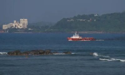
Maldives Coast Guard Ship Huravee departs island

Cost to US for war on Iran is $3.7bn in first 100 hours, says think tank

More than 120 killed in Israel’s Lebanon attacks as Beirut, south, east hit

Hungary confirms it is holding seven Ukrainian bank workers and $80m

‘Dates have the highest sugar content to fight Coronavirus’

Sunday Island 27 December – Headlines

#SundayIsland 17th December – Headlines

Sunday Island – 28th March

Sunday Island Headlines – 21 March

Sunday Island – 21st February – Headlines
-

 Features5 days ago
Brilliant Navy officer no more
-

 Opinion5 days ago
Sri Lanka – world’s worst facilities for cricket fans
-

 News2 days ago
Legal experts decry move to demolish STC dining hall
-

 Features5 days ago
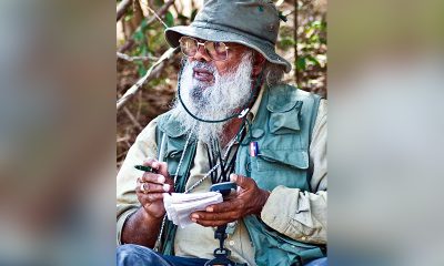
A life in colour and song: Rajika Gamage’s new bird guide captures Sri Lanka’s avian soul
-

 Business2 days ago
Cabinet nod for the removal of Cess tax imposed on imported good
-

 Features6 days ago
Overseas visits to drum up foreign assistance for Sri Lanka
-
 Features6 days ago
Sri Lanka to Host First-Ever World Congress on Snakes in Landmark Scientific Milestone
-
 Latest News2 days ago
Around 140 people missing after Iranian navy ship sinks off coast of Sri Lanka