Features
The changing faces of Galle Face
by Ismeth Raheem and Angeline Ondaatjie
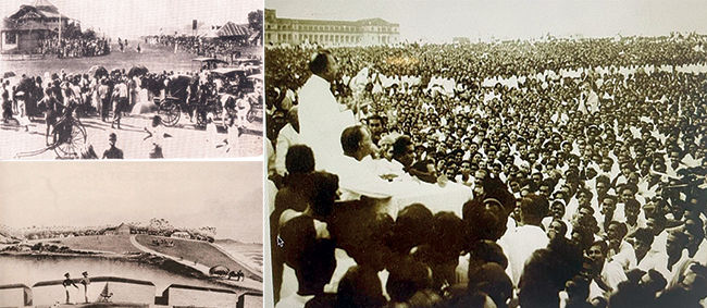
Galle Face is Colombo’s most-prized open-aired public space, extending over a mile along the Fort oceanfront in Colombo. Over the course of Sri Lanka’s history, it has been the de facto stage for landmark public gatherings. Most recently over the months of April to July 2022, the Galle Face Green was the centerstage of the People’s Aragalaya, a protest movement that arose from economic hardship in Sri Lanka. During those weeks the protestors renamed it Gotagogama (GGG) and even had a Google marker to prove it. On July 9, 2022, unprecedented crowds from all parts of Sri Lanka gathered in the Galle Face Area breaking attendance records of Prime Minister D.S. Senanayake’s funeral in 1952, the 1953 hartal, and Pope Francis’s holy mass in 2015.
While it seems like it has been iconized by the Aragalaya over just the last few months, Galle Face’s rich history dates back centuries. Prior to the first fortifications that adorn it today (built by the Portuguese in the 16th century) it was referred to as Mapanne, meaning “large open plain”. Long before it became the open stretch of grassy plain sans trees/plants that we know it as, it was a large marsh land and part of the Colombo Lake (later known as the Beira Lake).
In this vast marshland, there were numerous small streams, ponds, and boulders. This extensive delta was created by numerous branches of the Kelani Ganga, the main river that flows to the sea by the ancient Kelani Temple, and is the third longest in the island. The Portuguese used the flooded areas as a defensive measure against possible attacks from the Kandyan Kingdom. Later the Dutch put their efforts into controlling and channeling the lake by creating a network of connected canals.
On the other hand, the British, who succeeded the Dutch in 1789, spent their efforts in reclaiming much of the lake area, believing that this would alleviate the flooding of Colombo’s low-lying areas. The original open stretch on the Southern side of the Fort (now known as Galle Face Esplanade) somehow gained more land around its periphery. Many of the new buildings that adorn the skyline of Slave Island (which owes its name to the slave tenements confined to a moat-surrounded land mass during the Dutch period) are in this reclaimed area of the Beira Lake.The open “Green” stretch was only seldom used for recreation under the Portuguese and Dutch occupations. This changed during the first decades of the 19th century, when it came into its own as the amusement, exercise, and sports venue that it is used as today.
The Galle Face Burial Grounds
Galle Face hosted the site of the first British burial grounds for over half a century from 1803, until the tombstones were translocated to the General Cemetery at Kanatte in 1877. This land may have been a part of the site that was reclaimed by the Dutch Administration of the East India Company around 1700-1750. [See Map of Colombo, 1750]. The timber palisade enclosing the cemetery and the tombstones are clearly indicated in the views of the Galle Face in the coloured engravings by John Deschamps [1848]. The burials were necessitated by the British army’s heavy military casualties from the wars with the King of Kandy during the administration of Governor North between 1801-1805.
For years, the Galle Face Cemetery was known as the “Padre Bailey’s Godown”, after the Archdeacon Bailey who officiated at the burials. J. P. Lewis’s “Tombstones and Monuments of Ceylon”, records the inscriptions on the headstones.
The open stretch of land outside the South Gate of the Colombo Fort was the site of military executions. In close proximity, at the northern end of the current esplanade, featured a guardhouse and a large block of wood: a “whipping post” where punishments were administered by public flogging.
The Esplanade and the Recreation Galle Face Green
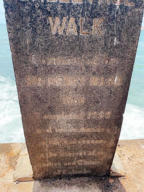
In 1853, the sea-front walk of the Galle Face was constructed by Governor Henry Ward. An inscription on the pillar midway through the walk still stands; it reads “Galle Face Walk completed in 1856 and recommended to his successors in the interest of the Ladies and Children of Colombo”.
Henry Charles, the author of “Ceylon and the Cingalese” compared Galle Face Green to Hyde Park in London. “At half past five the “Galle Face, or the Hyde Park of Colombo, begins to wear an animated appearance, there being many vehicles and horses in motion. Every description of conveyance to be seen driving around the Galle Face, from the Long Acre Built carriages of the Governor, the dashing phaeton of the wealthy merchant, the unassuming gig, the country- built palanquin and the humble bandy.”
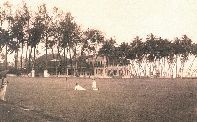
The Galle Face Esplanade by John Deschamps shows the view from the ramparts of the Fort of Colombo facing the Galle Face Green. In the foreground are two Royal Military officers enjoying the scene. The Beira Lake, which was used for aquatic sports, the Round Pavilion, and Grand Stand of the Race Course are also in the background. The large bungalow towards the right of their view is the building that was later replaced by the Galle Face Hotel. The country house in the distant far right is the home of Governor Maitland, which later became the Mount Lavinia Hotel. The Race Bungalow, as the Grand Stand was later called, became The Colombo Club and still exists within the premises of the Taj Hotel.
In 1829, Sir Edward Barnes introduced horse racing at Galle Face after leveling a mile and a quarter of the grounds. While the upper floor of the conical-roofed race stand had the best views of the horse racing, it was also the venue for grand balls. The verandahs of the ball room were used for card playing, darts, and other favorite past times. By the 1830s, cricket and a whole host of Victorian sports and leisure activities were introduced and enjoyed by both the British and middle class locals, making it the most popular space in Colombo.
The Galle Face Railway Line Controversy (1873-75)
The railway line from Fort to the coast was originally planned to cut through the Galle Face Green. The Railway authorities set out an intended rail track from Maradana (the first railway station in Ceylon), Colombo Fort to Moratuwa cutting across Galle Face created a major controversy which involved the public, the legislative council, and the Governor of Ceylon.
The Times of Ceylon of Dec 4, 1873 stated – It is intended “to carry a line from a station to be constructed in the vacant plot near the Lotus Pond road, where passengers and goods from the Fort may be loaded, and where trains may run in connection with the railway station at Maradana; from the Fort Station, the line will diverge at the Police Station on the Galle Face, and skirt the sea-beach as far as Mount Lavinia”.
Public discontent at the impending desecration of the Galle Face walk soon became articulate – but the official trace by the railway planners did not appear to admit any change. On October 14, 1874, the Governor gave another version where he stated, “Inconvenience has been apprehended from trains running so near the road of the Galle Face, but care shall be taken that the train shall not run during evening”.
Some of the members of the Council were still discontent and by January 6, 1875 the tender notices for the construction of the Southern Line were published in the public press. The debate continued. The Government was prominently reminded of Sir Henry Ward’s recommendation of Galle Face to the Women and Children of Colombo by the Council and the public refused to be reconciled of this infringement. Yet the notices calling for tenders did not weaken the effort to save the Galle Face Walk.
The Council reminded the Governor of Galle Face’s dedication to the public and refused that it be desecrated and rendered unsafe by the “snorting and rattling and smoking vapours of the railway train”. The Governor responded by accepting the protest, since they represented the ladies of Colombo who were afraid that they will be deprived of their drive, and stated “I feel there is a good deal in this objection”.
On March 13, 1875, the Government took serious notice of the protests and assured the public that an alternate route will be used, which prompted the Observer in proclaiming in its issue of March 15, 1975: “GALLE FACE SAVED.”
Subsequently, the railway line from Fort as we see it today is connected to Compani Vidiya via an underground tunnel to the coast at Kollupitiya, honouring the decision to leave Galle Face Green untouched.The public recreation space and sacredness of Galle Face was saved, and allowed Sri Lankans to witness the historic mass independence rally on February 4, 1948. Radio Ceylon broadcasts were heard as far as Mount Everest, legendary school cricket matches, and most recently, the peaceful protests of the Aragalaya were also on Galle Face. The current legislators should learn their history and maintain the freedom and sanctity of this earth lung that is the only true free space in Colombo.


![]() The International Labour Organisation (ILO) now defines a living wage as the wage level necessary for workers and their families to afford a decent standard of living, given national circumstances, for normal hours of work. This standard of living is operationalised through the cost of essential goods and services, typically including food, housing, healthcare, education, transport, and a modest allowance for contingencies and social participation.
The International Labour Organisation (ILO) now defines a living wage as the wage level necessary for workers and their families to afford a decent standard of living, given national circumstances, for normal hours of work. This standard of living is operationalised through the cost of essential goods and services, typically including food, housing, healthcare, education, transport, and a modest allowance for contingencies and social participation.
In contrast, “cost of living” in economics is a broader price index concept that tracks the overall prices of a representative consumption basket but is not inherently normative about what constitutes decency or dignity.
Living wage methodologies effectively translate a cost-of-living basket, specified for a given family size and living standard, into a monthly income requirement for workers, thereby linking real wages to human development objectives rather than only to market productivity.
Methodologies for computing a living wage
Most contemporary living wage estimates follow a structured “cost of a basic but decent life” approach built around three steps: defining a reference family, costing a normative consumption basket, and converting that cost into a wage per worker.
The Anker methodology, widely used in global supply chains and in Sri Lanka, is a leading example: it defines a model family (e.g., 2 adults and approximately 2–3 children), estimates the cost of a low-cost nutritious diet, adequate housing, and non-food essentials, and then allocates that cost over expected number of full-time workers per family.
Within the Anker framework, the food component is based on locally appropriate diets meeting caloric and nutritional norms, priced using local market surveys and adjusted for waste and home preparation.
Housing costs are derived from standards for minimally acceptable housing (e.g., durable materials, sufficient space, basic services), using rents or imputed rental values from empirical fieldwork. Other essential expenditures, health, education, transport, clothing, and a small margin for unexpected events, are typically estimated as a percentage mark-up over food and housing costs, derived from national household survey data.
Finally, the methodology sets a reference number of workers per family, divides total family living costs by this number to get a net living wage, and then adjusts to a gross living wage by adding payroll taxes and mandatory deductions. Periodic updates are made using consumer price indices (CPIs) to reflect inflation or deflation and, where necessary, new field surveys to capture structural shifts in prices and consumption patterns.
Sri Lanka’s living wage estimates and their link to cost of living (Anker Methodology)
 Sri Lanka has been the subject of several living wage studies, notably for the tea estate sector and for urban and rural areas, using the Anker methodology.
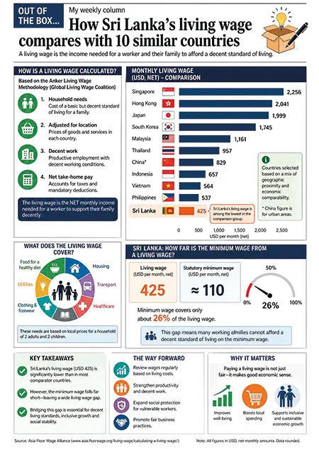
In the tea estate sector, an updated 2024 Anker report estimates the cost of a “basic but decent” standard of living for a typical family at about LKR 78,067 per month (approximately USD 260), implying a gross living wage of LKR 48,584 per month (USD 160) and a net, take-home living wage of LKR 44,357.
For urban Sri Lanka, the Anker Living Wage Reference Value was originally set at LKR 84,231 per month in April 2022, corresponding to a net living wage of LKR 77,492 plus social security contributions. After cumulative inflation of about 36.9 percent between April 2022 and June 2025, the updated gross urban living wage is estimated at approximately LKR 115,291 per month (around USD 385), consisting of a net living wage of LKR 106,068 and social security contributions of LKR 9,223
These Sri Lankan figures are explicitly derived from cost-of-living calculations: they incorporate the cost of food, housing, utilities, health, education, and other essentials at local prices and then convert these into wages per adult worker, assuming roughly 1.7–1.8 full-time earners per family. Because living wage estimates are indexed to actual price dynamics, periods of high inflation, as Sri Lanka experienced in 2022–2023, translate almost mechanically into sharp upward revisions in living wages, underlining the tight coupling between living wage levels and the evolving cost of living.
Comparative living wages: Sri Lanka and other countries
Cross-country comparisons require careful normalisation because living wages reflect local prices, family structures, and social norms, but several datasets provide a structured basis for comparison. [asia.floorwage](https://asia.floorwage.org/living-wage/calculating-a-living-wage/)
The Asia Floor Wage Alliance, for example, publishes a regional living wage benchmark expressed in purchasing power parity (PPP) terms, with a 2024 benchmark of 1,750.54 PPP dollars per month converted into local currencies using country-specific PPP exchange rates.
Using this PPP-based approach, the 2024 living wage equivalent for Sri Lanka is estimated at around LKR 158,353 per month, assuming a PPP exchange rate of about 90.5 Sri Lankan rupees per PPP dollar.
This PPP-normalised figure is substantially higher than the Anker 2024–2025 estate-sector and urban living wage estimates in nominal rupees, partly because the Asia Floor Wage benchmark is set to ensure a more harmonised standard across Asian garment-producing economies and uses a single PPP wage target.
These figures indicate that, within this PPP-based framework, Sri Lanka’s living wage in local currency is relatively high compared to countries such as India and Bangladesh, but the comparison reflects both different PPP exchange rates and domestic price structures.
From a cost-of-living perspective, this pattern is consistent with Sri Lanka being a lower-middle-income country with relatively higher prices for some essentials compared with low-income South Asian economies, especially after recent macroeconomic and inflationary shocks.
Global patterns and high-income economies
Global datasets covering more than 200 countries show that typical-family living wage levels, whether calculated in PPP or nominal terms, tend to correlate positively with national income levels, with North America, Western Europe, and Australia displaying the highest living wage values.
In this global distribution, living wages in middle- and low-income regions of Asia, Africa, and Latin America are lower in absolute terms, though the ratio of living wage to median wages or statutory minimum wages can be high, underscoring the gap between decent-work standards and prevailing labour market outcomes.
Interestingly, some studies note that rural living wage estimates can be relatively high in poorer countries because limited infrastructure and service availability raise the cost of accessing a given standard of living, such as safe water, transport, and education.
For Sri Lanka, rural Anker living wage benchmarks similarly reveal the importance of non-food costs, such as transportation to schools, health facilities, and workplaces, in shaping the total family budget, despite lower nominal rents in many rural areas.
Living wage, social policy, and Sri Lanka’s development trajectory
The emerging international consensus around a living wage is rooted in the human rights-based notion of a “decent life” rather than a subsistence minimum or an arbitrarily set statutory floor.
From a social science perspective, incorporating living wage benchmarks into wage-setting institutions, collective bargaining, and social dialogue reorients labour markets toward social reproduction, intergenerational mobility, and social cohesion, rather than merely cost competitiveness.
For Sri Lanka, where recent crises have eroded real wages and increased household vulnerability, living wage estimates such as the Anker urban and estate-sector benchmarks provide an analytically rigorous yardstick for evaluating whether current wage policies and social transfers are adequate relative to the actual cost of a basic but decent life.
Comparisons with regional PPP-based benchmarks like the Asia Floor Wage suggest that, while Sri Lanka’s living wage requirement in local currency is relatively high, the country also faces significant affordability challenges, especially for low-paid workers in export sectors and informal employment, whose earnings often fall short of these normative thresholds.
In policy terms, the living wage framework highlights the need for coordinated approaches that combine wage-setting reforms, inflation-sensitive social protection, and productivity-enhancing investments, so that rising living-cost-consistent wages do not simply translate into inflationary spirals or employment losses.
For empirical research in Sri Lanka, these benchmarks open avenues for micro-level analysis of wage gaps, household coping strategies, gendered labour outcomes, and the distributional effects of macroeconomic adjustment, all anchored to a transparent and internationally recognised living wage methodology.
(The writer, a senior Chartered Accountant and professional banker, is Professor at SLIIT, Malabe. The views and opinions expressed in this article are personal.)
Echoes of ‘The Walk for Peace’
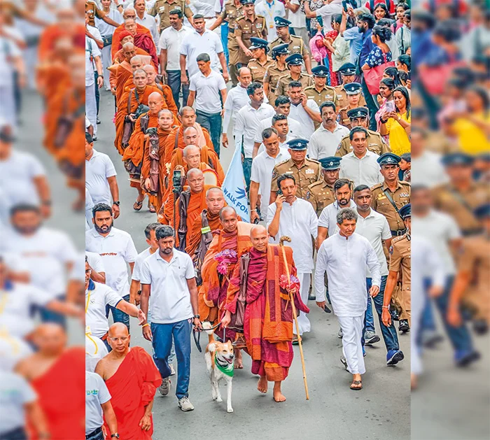
The international Walk for Peace’ reaching Colombo, joined by a large number of monks and devotees, led by spiritual leader Ven Bhikku Pannakara, with the peace dog ‘Aloka,’ completing the 161 km journey.The walk commenced in Dambulla on April 22 following the main ceremony at the Jaya Sri Maha Bodhi in Anuradhapura.Pic by Nishan S.Priyantha
by Ven. Dr. Kirinde Assaji Nayaka Thero
Chief Incumbent, Gangaramaya Temple, Hunupitiya, Colombo
Throughout human history, one of the greatest and most complex challenges has been the establishment of lasting peace and the maintenance of harmonious coexistence. While peace is often understood simply as the absence of war or armed conflict, a deeper, spiritual perspective reveals it as a profound state of social and mental harmony. It is an ideal that must be cultivated within individuals as well as across societies.
Buddhism offers one of the most practical and timeless philosophies of peace. The teachings of the Buddha are rooted in non-violence and the four sublime virtues—loving-kindness, compassion, sympathetic joy, and equanimity. Central to this philosophy is the idea that true peace in the world begins with inner peace within the individual. Conflict, the Buddha taught, arises not on battlefields but within the human mind, driven by greed, hatred, and delusion. Without overcoming these negative forces, lasting peace in the external world remains unattainable.
In today’s world, marked by geopolitical tensions, economic competition, and social unrest—this inward approach to peace is more relevant than ever. Despite technological advancement, humanity continues to grapple with violence and division. The Buddha’s teaching points instead to an internal struggle: a battle against anger, jealousy, and ignorance. Rather than weapons of destruction, Buddhism promotes wisdom, compassion, patience, and discipline as the tools to overcome conflict.
The path to peace begins with understanding its causes. Just as muddy water becomes clear when left undisturbed, the human mind achieves clarity and calm when negative emotions are subdued. This principle is reflected in the Buddha’s intervention during a historic dispute between the Sakya and Koliya clans over water, where he reminded them of the greater value of human life, thereby preventing bloodshed.
In a world increasingly threatened by conflict over limited resources and political power, such lessons remain highly relevant. The Buddha also emphasised the principle of moral causation—actions have consequences.
Yadisaṃ vapate bijaṃ tadisaṃ harate phalaṃ
Kalyaāṇakariī kalyaṃ papakariī ca papakaṃ
Pavutthaṃ tata te bijaṃ phalaṃ paccanubhossasiti
“As one sows the seed, so does one reap the fruit.
The doer of good receives good results, and the doer of evil receives evil results.
Dear one, whatever seed you have planted, you will experience the corresponding fruit of it.”
At the heart of Buddhist ethics is respect for life. All beings fear harm and seek happiness, and therefore, violence against others cannot lead to true well-being. This message is particularly significant in an era where the race for power and advanced weaponry continues to overshadow compassion and humanity.
The fundamental moral discipline in Buddhism is respect for life and opposition to harming living beings. The Buddha taught that all beings desire happiness, and fear suffering, and that harming others will not lead to happiness.
Sabbe tasanti dandassa
sabbe bhayanti maccuno
attanam upamam katva
na haneyya na ghataye.
“All tremble at violence; all fear death. Comparing others with oneself, one should neither kill nor cause others to kill.”
Despite technological advancement, the world appears to be moving backwards in terms of compassion and peace. Power-driven politics and the race for advanced weaponry cannot provide lasting solutions. Global leaders, diplomats, and policymakers must urgently recognise the importance of the tolerant, balanced, and non-violent approach taught in Buddhism. Protecting the right to life of all beings, and acting with compassion beyond divisions of race, religion, or politics, is the only true foundation for world peace.
Sri Lanka, as a nation nourished by the essence of Buddhism, has long upheld this principle. The Sri Lankan tradition, rooted in boundless loving-kindness and compassion, strives to uphold human values even amidst the harsh realities of global politics. From the respect shown by King Dutugemunu towards King Elara, to Sri Lanka’s stance at the 1951 San Francisco Peace Conference invoking the words “Hatred is never appeased by hatred,” to recent humanitarian acts in rescuing sailors in distress—these all reflect a single philosophy: valuing human life above all divisions.
The presentation of a “Joint Declaration for Peace” by the Mahanayake Theros at Gangaramaya Temple recently reaffirmed Sri Lanka’s commitment to global peace. Despite global power struggles, Sri Lanka continues to stand as a symbol of compassion and peace, reminding the world that human kindness is more powerful than weapons.
Institutions such as the Gangaramaya Temple have played a vital role in fostering social harmony. Through charitable, educational, and cultural programmes, the temple has encouraged unity across religious and ethnic lines, while also promoting interfaith dialogue and cooperation.
The annual Navam Maha Perahera, organised by the temple, stands as a powerful symbol of national unity, bringing together people from diverse backgrounds in a shared celebration. Similarly, vocational training and educational initiatives have helped empower young people from all communities, strengthening social cohesion.
A recent “Walk for Peace,” led by Venerable Pannakara Thero and supported by the monastic community, further underscored this commitment. More than a physical journey, it represented a spiritual effort to cultivate peace within the human heart and spread a message of compassion to the wider world.
One of the most touching aspects of the event was the participation of a dog named “Aloka,” which accompanied the monks throughout the journey. This simple yet powerful image reflected the Buddhist teaching that all living beings value life and deserve compassion, highlighting the universal nature of peace.
Ultimately, the Buddha’s message remains clear: peace cannot be achieved through hatred or violence. True peace arises from self-discipline, moral conduct, and the cultivation of a pure mind. As the teaching states, avoiding evil, doing good, and purifying one’s mind is the path laid down by the Buddha.
Let us plant the seeds of peace within our hearts and nurture them with loving-kindness. (“Sabba papassa akarananṃ – kusalassa upasampadā – sacitta pariyodapanaṃ – etaṃ Buddhana sasanaṃ”)
In a time when global tensions continue to rise, this timeless message serves as a powerful reminder that lasting peace begins within each individual—and that compassion remains humanity’s greatest strength.
“Devo vassatu kalena – sassa sampatti hetu ca
Pito bhavatu loko ca – rajaā bhavatu dhammiko”
(“May the rains fall at the right time, bringing about abundant harvests.
May the world be joyful and prosperous.
May the ruler be righteous and just.”)
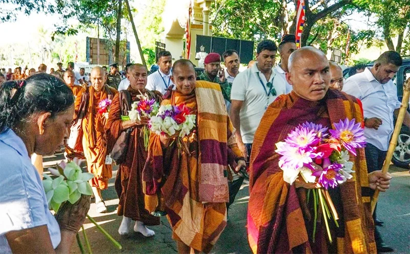
The ongoing peace march by a group of international Buddhist monks has captured the sentiment of Sri Lankans in a manner that few public events have done in recent times. It is led by the Vietnamese monk Venerable Thich Pannakara who is associated with a mindfulness movement that has roots in Vietnamese Buddhist practice and actively promoted among diaspora communities in the United States. The peace march by the monks, accompanied by their mascot, the dog Aloka, has generated affection and goodwill within the Buddhist and larger community. It follows earlier peace walks in the United States where monks carried a similar message of mindfulness and compassion across communities but without any government or even media patronage as in Sri Lanka.
This initiative has the potential to unfold into an effort to nurture a culture of peace in Sri Lanka. Such a culture is necessary if the country as the country prepares to move beyond its history of conflict towards a more longlasting reconciliation and a political solution to its ethnic and religious divisions. The government’s support for the peace march can be seen as part of a broader attempt to shape such a culture. The Clean Sri Lanka programme, promoted by the government as a civic responsibility campaign focused on environmental cleanliness, ethical conduct and social discipline, provides a useful framework within which such initiatives can be situated. Its emphasis on collective responsibility and shared public space makes it sit well with the values that peacebuilding requires.
government’s previous plan to promote a culture of peace was on the occasion of “Sri Lanka Day” celebrations which were scheduled to take place on December 12-14 last year but was disrupted by Cyclone Ditwah. The Sri Lanka Day celebrations were to include those talented individuals from each and every community at the district level who had excelled in some field or the other, such as science, business or arts and culture and selected by the District Secretariats in each of the 25 districts. They were to gather in Colombo to engage in cultural performances and community-focused exhibitions. The government’s intention was to build up a discourse around the ideas of unity in diversity as a precursor to addressing the more contentious topics of human rights violations during the war period, and issues of accountability and reparations for wrongs suffered during that dark period.
Positive Response
The invitation to the international monks appears to have emerged from within Buddhist religious networks in Sri Lanka that have long maintained links with the larger international Buddhist community. The strong support extended by leading temples and clergy within the country, including the Buddhists Mahanayakes indicates that this was not an isolated effort but one that resonated with the mainstream Buddhist establishment. Indeed, the involvement of senior Buddhist leaders has been particularly noteworthy. A Joint Declaration for Peace in the world, drawing on Sri Lanka’s own experience, and by the Mahanayakes of all Buddhist Chapters took place in the context of the ongoing peace march at the Gangaramaya Temple in Colombo, with participation from the diplomatic community. The declaration, calling for compassion, dialogue and sustainable peace, reflects an effort by religious leadership to assert a moral voice in favour of coexistence.
The popular response to the peace march has also been striking. Large numbers of people have been gathering along the route, offering flowers, water and support to the monks. Schoolchildren have been lining the roads, and communities from different religious backgrounds extend hospitality. On the way, the monks were hosted by both a Hindu temple and a mosque, where food and refreshments were provided. These acts, though simple, carry a message about the possibility of harmony among Sri Lanka’s diverse communities. It helps to counter the perception that the Buddhist community in Sri Lanka is inherently nationalist and resistant to minority concerns that was shaped during the decades of war and reinforced by political mobilisation that too often exploited ethnic identity.
By way of contrast, the peace march offers a different image. It shows a readiness among ordinary people to embrace values of compassion and coexistence that are deeply embedded in Buddhist teaching. The Metta Sutta, one of the most well-known discourses in Buddhism, calls for boundless goodwill towards all beings. It states that one should cultivate a mind that is “boundless towards all beings, free from hatred and ill will.” This emphasis on universal compassion provides a moral foundation for peace that extends beyond national or ethnic boundaries. The monks themselves emphasised this point repeatedly during the walk. Venerable Thich Pannakara reminded those who gathered that while acts of generosity are commendable, mindfulness in everyday life is even more important. He warned that as people become unmindful, they are more prone to react with anger and hatred, thereby contributing to conflict.
More Initiatives
The presence of political leaders at key moments of the march has emphasised the significance that the government attaches to the event. Prime Minister Harini Amarasuriya paid her respects to the peace march monks in Kandy, while President Anura Kumara Dissanayake is expected to do so at the conclusion of the march in Colombo. Such gestures signal an alignment between political authority and moral aspiration, even if the translation of that aspiration into policy remains a work in progress. At the same time, the peace march has not been without its shortcomings. The walk did not engage with the Northern and Eastern parts of the country, regions that were most affected by the war and where the need for reconciliation is most acute. A more inclusive geographic reach would have strengthened the symbolic impact of the initiative.
In addition, the positive impact of the peace march could have been increased if more effort had been taken to coordinate better with other civic and religious groups and include them in the event. Many civil society and religious harmony groups who would have liked to participate in the peace march found themselves unable to do so. There was no place in the programme for them to join. Even government institutions tasked with promoting social cohesion and reconciliation found themselves outside the loop. The Clean Sri Lanka Task Force that organised the peace march may have felt that involving other groups would have made it more complicated to organise the events which have proceeded without problems.
The hope is that the positive energy and goodwill generated by this peace march will not dissipate but will instead inspire further initiatives with the requisite coordination and leadership. The march has generated public discussion, drawn attention to the values of mindfulness and compassion, and created a space in which people can imagine a different future. It has been a special initiative among the many that are needed to build a culture of peace. A culture of peace cannot be imposed from above nor can it emerge overnight. It needs to be nurtured through multiple efforts across society, including education, religious engagement, civic initiatives and political reform. It is within such a culture that the more difficult questions of power sharing, justice and reconciliation can be addressed in a constructive manner.
by Jehan Perera

Dulani and Samarawickrama set up Sri Lanka’s victory in T20I series opener

Heat Index at Caution Level in the Northern, North-central and North-western provinces and in Kegalle, Trincomalee and Batticaloa districts during the day time

Showers or thundershowers will occur in most parts of the island after 1.00 pm

Treasury chief’s citizenship details sought from Australia

President Anura Kumara Dissanayake handing over a sapling of the Sri Maha Bodhiya in Anuradhapura to Ven Bhikku Pannakara

USD 625,000 meant for US Postal Service goes missing

‘Dates have the highest sugar content to fight Coronavirus’

Sunday Island 27 December – Headlines

#SundayIsland 17th December – Headlines

Sunday Island – 28th March

Sunday Island Headlines – 21 March

Sunday Island – 21st February – Headlines
-

 News6 days ago
Lanka faces crisis of conscience over fate of animals: Call for compassion, law reform, and ethical responsibility
-
 News5 days ago
Whistleblowers ask Treasury Chief to resign over theft of USD 2.5 mn
-

 News5 days ago
No cyber hack: Fintech expert exposes shocking legacy flaws that led to $2.5 million theft
-

 News2 days ago
BIA drug bust: 25 monks including three masterminds arrested
-

 Business3 days ago
Nestlé Lanka Announces Change in Leadership
-

 News2 days ago
Banks alert customers to phishing attacks
-

 News3 days ago
Hackers steal $3.2 Mn from Finance Ministry
-

 News6 days ago
USD 2 mn bribe: CID ordered to arrest Shasheendra R, warrant issued against ex-SriLankan CEO’s wife