Features
More on jungle treks: Lahugala and bold leopards

BY H A I Katugaha
(Continued from last week)
One morning in the 1950’s we had gone across into Yala Block 2 and our destination was Walaskema in search of the famous crossed tusker, so named because of the crossing of the tusks in front. We had Block 2 all to ourselves. Parking the jeep, we began our walk to Walaskema. There were four of us in the party, namely Uncle Sam, Upali, our tracker and myself.
We saw a leopard sitting under a tree. He got up and started walking towards us. This was most unusual. We shouted at him but he took no notice at all. He growled at us and kept getting closer. Shouting at him we walked backwards and even threw stones at him. One thrown by the tracker hit him on his head, but he kept on coming.
Having reached the jeep, Upali raced the engine and sped towards him. The leopard then ran off into the jungle. Leopards usually run off at the sight of man, and the difficulty is to get close to one. Uncle Sam was of the opinion that this one may well have been used to humans since the Kataragama pilgrims passed this way every year. Maybe he even had a taste of human flesh by eating the corpse of a pilgrim that had died during the walk across Kumbukkan Oya to Menik Ganga. It was a large male animal in the prime of his life.
We reached Walaskema, which was a water-hole, and though we waited till evening the famous tusker did not come to drink water. On our way back we did see a herd of elephants across the Pilinnawa plains.
Years later while camping out at Kosgasmankada in Yala Block 1, one night I noticed some movement under one of the lanterns that we had hung around the camp to keep animals away. Using my torch I discovered that it was a leopard that sat right under the lantern and watched our camp. Soon several torches were focused on it and we had a good look at this fine male leopard. One member of our party then turned the vehicle and put on the headlights. There he was in all his glory watching us with apparent delight.
Next morning we reported this unusual behavior to the park office and were told that this was a bold leopard that had even attacked a labourer attached to the department while walking along at the campsite. The rule is that a leopard will run off at the sight of man unless man has wounded him. It is always best to remember that there are exceptions to every rule.
Land of the gentle giants
At dawn, in the early 1960’s, I lay stretched out on a mat in the verandah of the old Irrigation Department bungalow at Lahugala. A regular swish-swish close by informed me that an elephant, perhaps two, were feeding on the luscious beru grass close to the sluice. It was still very dark. The first vocalists for the morning were a pair of magpies. Their whistling calls were welcome indeed. Next a shama gave vent to his repertoire of vocal renderings. Then the pair of brown fish owls that was always to be found near the sluice finished their serenade with a short burst of hoo hoo.
As darkness gave way to light that misty morning, I watched the dark shape of an elephant slowly moving up to the rock in front of the bungalow. He stood still, probably enjoying the cool breeze that was blowing across the tank. After about 15 minutes he came down and walked towards the well.
Sammy, the Department’s watcher at the bungalow, kindly brought me a hot cup of tea and whispered, “Sir, be careful when you go for a wash, there is an elephant by the well.” I thanked him for his concern.
By the time my friends and I finished our tea, the elephant left the well and moved off into the jungle to our right. We could now see that there were two elephants feeding by the sluice. About 7 am they slowly walked up the bend of the tank and faded away to the left of us.
Across the tank, felled logs of the majestic trees that they once were, stood out in the early morning sun. It happened to be the depot of the State Timber Corporation and quite an eyesore in such a wonderful setting. Birds that were resting by the tank, such as painted storks, pelicans, teal, open-billed storks and a few white-necked storks, took off to look for breakfast. Four adjutant storks began their stately walk in search of food.
It was a typical morning at Lahugala. As we walked up to the rock a solitary pied kingfisher hovered momentarily, dived and came up with a fish. He flew to his perch, flicked the fish up and expertly swallowed it head first. The purple herons and the coots were active in the grass, while the beautiful jacanas were flitting over the lotus leaves looking for food.

Lahugala was then only a forest reserve and not a national park. The tank was managed by the Irrigation Department and Sammy was its watcher that looked after the sluice. Later Lahugala became an elephant reserve. Elephants were the chief attraction and they were to be seen throughout the year, but during the dry season from July to September, they congregated in large numbers. During this period, the herds gathered here for water and for the beru grass that they loved so much. There was always a resident population of elephants numbering about twenty. It was not till the 1970’s that it finally became a national park. Though it was only five square miles in extent it was a haven for elephants.
That morning we got on our scooters and went to the village for breakfast. Coming back for a bath in the tank was always refreshing. Our lunch over we did have a short snooze, leaving Sammy on the lookout for elephants, It was not till 2 pm that the elephants began to come to the tank. The first to arrive were solitary bulls, six of whom arrived from different spots and waded into the tank. That evening the herds came late, and by 5.30 pm there were over 50 elephants out in the tank. Depending on where the herds were, we walked up to the nearest tree and observed them, feeling quite safe. (Walking in the park was allowed in those days.)
One afternoon, Mr.Peter Jayawardena, who was the Wildlife Department’s ranger stationed at Lahugala, took us for a walk along the bund. Hearing a noise he led us into the jungle. There in a clearing were three elephants lying flat and sleeping. The noise that we heard was their snoring. They were soon joined by another that came up to them, laid himself down and then slept. After a while Mr. Jayawardena clapped. The four elephants were up instantly and crashed away into the jungle. It was amazing to see such large animals get up and run so quickly. The jungle was soon silent.
At the time Lahugala was an elephant reserve, and the Wildlife and Nature Protection Society took the Irrigation Department’s old Bungalow on lease. It was renovated and made comfortable. The late Mr. Noel de Costa was responsible for getting the place into a satisfactory condition. Thereafter we were able to book the bungalow and stay in it in comfort. We had only to take our food and bedding with us.
During those days it was a common sight to see people walk into the jungle with guns and many dogs at their heel. Gunshots were heard every night. Venison was freely available at the bazaar. Poaching was rampant.
It has been my good fortune to see two leopards at Lahugala. One was on the road leading to the bungalow late one evening when we were returning from Kithulana. The other walked past the bungalow one night just as we were about to retire for the night, A bear came along the road one night and hooted, and we watched him by moonlight. Had he not made a sound we would never have seen him. Deer and wild boar were not seen in those early days, and no doubt poaching was responsible for this scarcity. Every night we heard gunshots..
Lahugala has always been a bird watcher’s paradise. The tank is a fine rendezvous for storks, herons, waders, and other water birds. The surrounding jungle abounds with birds. A pair of grey-headed fishing eagles had a nest on a tall tree close to the sluice. They carefully tended their nest every year. A pair of brown fish owls nested close by. Many raptorials were seen over the tank at all times. I have seen one black-necked stork in the 1970’s and several adjutant storks. The thrill was to spot the beautiful red-faced malkoha or the racquet-tailed drongo. On a short walk along the track leading to Heda Oya, one would invariably see the red-faced malkoha. In fact we named it Malkoha Lane. It was not uncommon to see them in groups of four to six.
It was during the time I was at Badulla that I was able to really explore Lahugala and its surroundings. One afternoon there were two bull elephants feeding by the sluice. Getting close to them, keeping behind the bund, I took photographs, but one of them suddenly charged. He could not have seen me and the wind was in my favour. I ducked down on the blind side of the bund and lay flat among some large granite blocks that were thankfully there. The bull elephant came up the bund and to my relief ran along it. Had I run in panic on that day I would not be writing this article.
I picked up my field glasses and went back to see what his problem was, this time from a very safe distance. He had suppurating gunshot wounds on both his hind legs, and his left ear was torn. Many other swellings on his body and head only proved how many times he had been shot at. Naturally he hated man. I informed the Wildlife and Nature Protection Society of this troublesome bull elephant, so that they could inform other occupants who came to this place to be careful of this animal.
Several months later I was at Lahugala with my family. Late one evening we met the elephant on the main road. A herd was feeding below the culvert and he was coming along to join the group. I was able to take a picture of him as he was crossing the culvert. While we were watching the herd I noticed that he was quickly moving parallel to us. and was trying to come in front of us. We moved ahead and waited for him. Sure enough he came to the road and immediately charged us. This time we were in a jeep and had no difficulty in avoiding his aggressive behaviour. He charged us three times on that day.
This bull elephant became quite a menace. He would wait quietly by the road and suddenly charge at any passing vehicle. Buses were his favourite targets. Three months later I was informed that he was shot. I drove down to verify if it was the same animal. It was truly the same troublesome bull, which was shot and had fallen in a chena close to Kithulana Tank. Birds were picking up dead maggots from his wounds. He had 23 wounds on the left side of his body and eight on his head. Finally he was at rest.
Lahugala was next declared a national park. The area began to be patrolled and it was at last getting the protection that it so richly deserved. It was in the late 1970’s that I saw the first herd of deer come out to feed. Wild boar soon made their presence felt.
One morning while I was seated on the rock, I met Appuhamy who came with a katty (a cutting blade with a long handle) on his ample shoulder. Having heard that I had come all the way to watch elephants, he took me to his chena, which was close to the Sengamuwa tank. To my horror I saw that his entire chena was devastated, having been trampled by a large number of elephants that had passed through. All his labour was lost in one night.
“You will see them at Lahugala today.” he said sadly. I gave him most of the cash I had with me and asked him about compensation. “Sir, I will get my money but I will have to give bribes in return; otherwise it will take months, perhaps even a year.” It is one thing for us to talk of conservation of the elephant from our homes and offices; while it is quite another matter for the poor cultivator. I told him it was a known fact that elephants come to Lahugala during that time of the year.
“True Sir, I would have harvested my crop by now, but the rains were delayed and so I planted late.” As I sat on the rock that evening and watched elephants pouring out of the jungle to my right, Appuhamy’s saying that I would see elephants at Lahugala that day kept ringing in my ears. As many as 186 elephants with four tuskers came to the tank. A herd of over a hundred elephants would have walked across his cultivation.
The conditions at the park improved rapidly, thanks to a dedicated staff that was stationed there. Being a small park it was easy to patrol. Poaching decreased. We began to see small herds of deer grazing close to the tank. I even saw a few sambhur.
There are many places of historical interest that one could visit while staying at Lahugala. One such place is Habutagala, where many ancient ruins, which include a forty-foot reclining statue of Lord Buddha in a cave, are found. Treasure hunters have dug into the statue. There is a small dagoba and several pillars to be seen. The most interesting features are Lord Buddha’s footprint carved in stone and an ancient stone inscription. These ruins belong to the Ruhunu period. Northern terrorists have attacked the village of Hulanuge twice.
Magul Maha Viharaya too is worthy of a visit. Situated close to Lahugala bazaar, it has several stone pillars and foundations. During the 1970’s, a unique moonstone was unearthed at this spot. It was in a fine state of preservation. Four of the elephants in the row of these animals carved on stone were dressed and had a rider on each. No other moonstone yet discovered anywhere in the country had this feature. Here again we find a small dagoba, a shrine room and a foundation of some structure with beautifully carved lions round its base.
More on jungle treks:…
Ancient stone inscriptions can also be seen. When conservation is completed some more interesting finds are likely to be found at this place.
Nilagiri Maha Seya is still covered in jungle. One has to cross Heda Oya and travel south along a jungle path to get there. We were warned to be extra careful and to make a loud noise when walking along, as there was a reputation for the presence of bears, in addition to the ever-present elephants. The walk was rewarding. The jungle was cool and had plenty of bird life to keep us occupied. My late brother, Upali, and Dr. Mahi Kottegoda accompanied me on all archaeological and nature-watching trips to the area. Kotte, as we called him, was an ardent bird watcher.
Nilagiri Maha Seya was in complete ruin. It was huge, with massive trees growing even at the summit. We were told that it was much bigger than the famous Tissamaharama dagoba. A large cylindrical stone kotha (crown of a Buddhist dagoba) was seen fallen at the very top of the dagoba, which resembled a hill covered in jungle.
A beautifully carved Bodhisatva statue is found at Mudu Maha Viharaya at Panama. This carving is in crystalline limestone and is really well done.
Lahugala became more and more popular. The Society bungalow was almost always occupied. Deer and wild boar were seen every day. Elephants were the main draw. One could see them every day of the year. A resident population of about 12 to 20 elephants never failed to appear. During the drought the numbers increased to about a hundred to 200 elephants. If we did not see them at Lahugala, we found them at Kithulana or Sengamuwa tanks.
Arugam Bay is only 12 miles away. It was a common practice to go there for the morning sea bath and bring back seafood for lunch. Then, followed by a well-earned siesta, we would wait for the elephants in the evening.
At ten past five, trumpeting announced the arrival of the herds as 32 elephants of different sizes ran to the water. They spread out in a line, had their drink and ran back to the jungle. They did not feed. It was obvious to us that they had arrived after a long walk. While we were wondering what had disturbed them, a large female, obviously the matriarch, led the 32 back to water. They were followed by over 80 more, who came out nearly in single file and waded into the tank. We counted them as they came out. We were seated on the rock in front of the bungalow.
Our friend Sammy whispered in my ear that more were coming. Sure enough another group came out to our left and walked over the bund to get into the tank. There were over 40 in this group. The two groups mingled freely and we saw a line of elephants across the Lahugala tank, a fabulous sight indeed. The bull elephants kept moving from one group to another testing the females for receptivity. One young female squealed and ran away from a bull. A larger one, probably the mother, came running to the bull and began stroking him around his ears. The bull immediately turned and began testing her.
We next noticed a huge bull elephant, which was the biggest in the gathering, coming along the bund. He made straight to the herds. Two smaller bulls took to their heels and left the herd to the big bull. Later in the evening when the elephants were leaving the tank, he was there by our rock with two female elephants. Yes, he was ready for a night of love.
It has been my good fortune to see six different tuskers at Lahugala. Two were really big ones, but sadly this gathering of over a 100 had none. I have observed mating of elephants at Lahugala on three occasions, too far for effective photography.
Up to about 1985 there was peace and tranquillity, then the terrorists began to attack the humble jungle villages. Soon the bungalow, the office of the Wildlife Department and the staff quarters were torched. The army soon moved in. One could still go past Lahugala on the way to the east coast at one’s own risk. The area was considered risky, and no one would dare to stay in the area.
The army is there and elephants still come to the tank. The small national park remains in mute silence. The deer and wild boar are no longer seen in daylight. Even elephants have been shot at. We can only hope that the interim cessation of hostilities will lead to permanent peace once again and we would be able to visit these places to enjoy what nature has bestowed so generously.
Reference: Trimen, Henry (1898). A hand-book to the flora of Ceylon, vol 3, p 216, Dulau & Co, London.
(Concluded)
(Excerpted from Jungle Journeys in Sri Lanka edited by CG Uragoda)


Today marks a truly historic and momentous occasion in the realm of transdisciplinary diplomacy in our country. We gather here with a twofold purpose of profound national and global significance: the establishment of the Science Diplomacy Forum, and the launch of the volume Science Diplomacy: National, Regional and Global Approaches in a Changing World.
This volume brings together valuable and timely contributions from internationally renowned experts representing all key regions of the world — North America, Latin America, Europe, Africa, West Asia, South Asia, and Oceania. It reflects a rich diversity of perspectives, experiences, and insights that speak to the increasingly interconnected nature of science, policy, and diplomacy in our rapidly transforming world.
I am deeply heartened — and indeed humbled — by the presence of such a distinguished constellation of leaders, professionals, intellectuals, scholars, and luminaries from diverse domains, including international relations, science and technology, higher education, and governance. It is rare to witness such an extraordinary and diverse assembly of intellectual, professional, and academic excellence under one roof. Your presence affirms the importance of the cause we serve and the promise of the path we are charting together. Your support, encouragement, and engagement give life, purpose, and direction to this vital endeavour.
As Chief Editor of this volume, it is both a great honour and a profound responsibility to extend a warm and heartfelt welcome to all our distinguished guests and invitees. I am conscious that this august gathering is not assembled to listen to a lengthy welcome address, but rather to engage with the substantive proceedings of this event, enriched by five eminent personalities, four distinguished speakers, and an able and competent moderator — all of whom possess exceptional mastery of the subject. I shall therefore be brief.
Among us today are former and current Ministers and people’s representatives, members of the diplomatic corps, Secretaries to Ministries, distinguished panelists, valued contributors to the volume, Vice-Chancellors, Members of the Board of Management and Academic Affairs Board of the BCIS, Heads of institutions, professors, senior government officials, professionals, journalists, and many others — too numerous to acknowledge individually, yet each of you is most warmly welcomed. I receive you all, whether present in person or online, with the utmost warmth, respect, and appreciation.
The panel discussion constitutes the pièce de résistance of this event. We are deeply honoured to be joined by four eminent personalities:
Her Excellency Siri Walt, Ambassador of Switzerland to Sri Lanka;
Professor Pierre-Bruno Ruffini, former Chair of the EU Science Diplomacy Alliance; and former Ambassadors Mr. Bernard Goonatilleke and Dr. Palitha Kohona — all of whom bring exceptional depth of experience and insight to this important subject.
Their discussion will be guided by our distinguished moderator, Mr. Naushard Cader, a truly cosmopolitan personality, widely respected for his breadth of knowledge and his keen understanding of global affairs and science diplomacy. I extend to all our speakers and our moderator a very warm welcome and my sincere appreciation for their willingness to share their wisdom with us this evening.
Allow me, however, to place this event in perspective.
We gather this evening not merely to introduce a book, nor solely to inaugurate a forum, but to reflect together on an idea whose time has unquestionably arrived.
We meet at a moment of profound global transition and conflict. The international landscape is marked by turbulence, uncertainty, and rapid transformation. The world is shifting from a relatively stable post–Cold War configuration toward an increasingly multipolar order. While multipolarity carries the promise of greater balance and strategic autonomy, it also brings intensified competition among major powers, fluid alliances, and growing unpredictability.
At the same time, the rules-based international order — which for decades provided smaller nations with a measure of predictability and protection — is under visible strain and threat. Institutions are contested. Norms are challenged. Economic interdependence deepens even as geopolitical fragmentation intensifies. Supply and value chains now account for nearly seventy percent of global trade, binding nations in complex webs of mutual dependence. Yet such interdependence has not prevented trade wars, sanctions regimes, technological decoupling, and regional conflicts.
For small and economically vulnerable states, this evolving environment is especially daunting. When global rules weaken, asymmetries of power become more pronounced. Bilateral negotiations between unequal partners can leave smaller nations disadvantaged. Without adequate legal, geological, scientific, technological, and diplomatic expertise, such states may struggle to safeguard their long-term national interests and sovereignty. Vulnerability, in the absence of knowledge and capacity, risks translating into marginalisation.
Overlaying this geopolitical transformation is a constellation of interconnected global challenges. Climate change is no longer a distant projection; it is a lived reality. Sea levels are rising. Extreme weather events are intensifying. Food, water, and energy security remain fragile. Pandemics have exposed vulnerabilities in global health systems. Cyber threats transcend borders. Environmental degradation, biodiversity loss, and marine pollution threaten livelihoods and ecosystems alike.
These challenges are systemic and transboundary. Almost every major issue — whether global, regional, or national in scale — involves science and technology, either in understanding root causes or in devising effective solutions.
Traditional diplomacy, while indispensable, is no longer sufficient on its own. The defining issues of our time are not purely political or military; they are scientific, technological, environmental, and societal. They demand evidence-based policymaking, interdisciplinary collaboration, and sustained transnational cooperation.
It is within this context that science diplomacy emerges — not as an academic abstraction, but as a strategic necessity.
Nowhere are these realities more visible than in the Indian Ocean.
Unlike the Atlantic or Pacific Oceans, which possess longstanding institutional architectures and extensive scientific mapping, the Indian Ocean remains comparatively underexplored and under-institutionalised. Covering roughly one-fifth of the world’s oceanic expanse, it carries a substantial share of global energy shipments and maritime trade. Its seabed resources — including critical and rare-earth minerals — remain only partially surveyed. Many of its coastal and island nations are developing economies with limited scientific and technological capacity to explore, monitor, and sustainably manage these resources.
The Indian Ocean is unique. It is bordered predominantly by developing and emerging states. It hosts remarkable cultural, religious, and political diversity. It is home to some of the world’s most climate-vulnerable communities. Increasingly, it has become a central theatre of global strategic competition, viewed by some nations through distinct geostrategic lenses.
This maritime space is simultaneously a lifeline and a fault line. It sustains global commerce and local livelihoods. Yet it is also a theatre where geopolitical interests intersect — sometimes converge, sometimes collide.
At the heart of this ocean lies Sri Lanka.
Geographically, our island sits astride one of the busiest East–West shipping routes in the world. Historically, Sri Lanka has been a hub of commercial, cultural, and intellectual exchange. Today, that strategic location presents both opportunity and responsibility.
Sri Lanka’s history, enriched by iconic figures such as Dr. Gamini Corea, Hon.
Lakshman Kadirgamar, Judge Christopher Weeramantry, Dr. Neville Kanakaratne and Dr. Jayantha Dhanapala, stands as a powerful testament to our long-standing contributions to global diplomacy and international governance. Our nation provided leadership within the Non-Aligned Movement, positioning itself as a bridge between civilizations at a time of deep ideological division. We also made history by producing the world’s first woman Prime Minister, affirming our commitment to political progress and inclusive governance.
Today, we are called upon once again to build upon this distinguished legacy — by championing regional unity, promoting sustainable development, and addressing critical contemporary challenges such as climate change, maritime security, and environmental sustainability.
We must navigate complex geopolitical currents while safeguarding sovereignty and strengthening economic resilience. We face vulnerabilities common to island and littoral states: climate change, coastal erosion, marine pollution, and supply chain disruptions. Our development aspirations must be balanced with environmental stewardship and maritime security considerations.
Yet within these challenges lies profound opportunity.
Sri Lanka can position itself as a regional convener — a hub for ocean science, climate research, marine biodiversity studies, disaster risk reduction, and blue economy innovation. Through platforms such as BIMSTEC, the Indian Ocean Rim Association, and SAARC, we can advance cooperative marine research, harmonise environmental standards, strengthen early warning systems, and promote sustainable maritime governance grounded in international law.
But to do so effectively, we must invest in knowledge — and in the diplomacy of knowledge.
Science diplomacy operates along three mutually reinforcing dimensions:
First, science in diplomacy — where scientific evidence informs foreign policy decisions.
Second, diplomacy for science — where diplomatic engagement enables international research collaboration and shared infrastructure.
Third, science for diplomacy — where scientific cooperation itself becomes a bridge for confidence-building, even when political relations are strained.
Importantly, science diplomacy extends beyond the natural sciences. The humanities and social sciences are equally vital. Technology must be guided by ethics. Data must be interpreted within cultural contexts. Policy must consider equity and justice. Diplomats of the future must be fluent not only in international law and negotiation, but also in scientific literacy and interdisciplinary thinking.
In a fragmented world, science offers a neutral vocabulary. It encourages transparency, peer review, and open data. It shifts discourse from rhetoric to evidence. It fosters long-term thinking in political environments often dominated by short-term calculations.
For small and vulnerable nations, science diplomacy is empowerment. It strengthens capacity. It enhances credibility. It enables engagement with larger powers on firmer ground — armed not merely with moral argument, but with data, research, and technical expertise.
The book we launch today reflects a diversity of experience and insight. It is intentionally transdisciplinary because the problems we face are transdisciplinary. It is intentionally global because no region can address these challenges in isolation.
In Sri Lanka, science diplomacy remains at a formative stage. The establishment of the Science Diplomacy Forum signals our determination to move beyond dialogue toward sustained institutional engagement. It envisions training programmes for diplomats and scientists, embedding scientific advisory mechanisms within governance structures, and building networks among universities, research institutes, industry, and policymakers. It seeks to cultivate a new generation equipped to navigate the interface between knowledge and negotiation.
We aspire for the Science Diplomacy Forum to be transformative — a true game changer.
Excellences, Ladies and Gentlemen,
We live in an era of mounting uncertainty — but also of extraordinary human ingenuity. The same interconnectedness that transmits crises also enables collaboration. The same technologies that disrupt can also heal and transform.
Change is inevitable. The deeper question is whether we will shape that change cooperatively, constructively, and inclusively.
For Sri Lanka, for the Indian Ocean region, and for the broader global community, science diplomacy offers a pathway beyond zero-sum thinking. It channels competition into collaboration around shared public goods. It aligns national interest with regional stability. It transforms vulnerability into resilience through knowledge.
Let this book be not merely a publication, but a platform for sustained reflection and action.
Let the Science Diplomacy Forum be not merely an institution, but a living bridge between evidence and policy, between research and responsibility, between nations and neighbours.
Let Sri Lanka reaffirm its role as a bridge — not a battleground — in the Indian Ocean.
In a world where rules may falter, let evidence guide us.
In a world where tensions may rise, let dialogue endure.
In a world of turbulence, let science diplomacy be our compass — guiding us toward peace, stability, dignity, and shared prosperity.
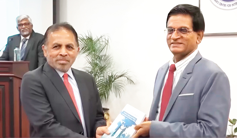
Welcome Address and Opening Remarks made by Emeritus Prof. Ranjith Senaratne
Former General President,
Sri Lanka Association for the Advancement of Science recently on the occasion of the Founding of the Science Diplomacy Forum and the Launch of the Book Science Diplomacy:
National, Regional and Global Approaches in a Changing World

From one day of celebration to 364 days of transformation
The international women’s day was just celebrated all over the world. I saw many organiations share their slogans, and organize panel discussions, presentations, and exhibitions to support women empowerment. Slogans, themes, colors play vivid and vociferous role across the world, commemorating the international women’s day.
Alas, the colors are faded, slogans are weaned, themes are forgotten, over the next 364 days, pushing UN Chapter on Women’s Rights come up with more illustrious themes and slogans.
From Bread and Peace to Rights and Action
According to the recorded history, the Women’s day first introduced on 28th February 1909 in America, raising a voice of women against poor working conditions and poor pay in garment factories. This took a more revolutionary form in 1917 in Russia against World War I, where a mass of women protested under the theme of “Bread and Peace”.
Starting from basic needs such as bread and peace, the International Women’s Day theme has evolved towards freedom and independence, justice and inclusion.
Over the years, the rise of feminism brought cultural refinements and highlighted women’s rights. Looking back the historical evolution of women’s role, we see that matrimony has faded and patriarchy evolved with religious and geopolitical forces intertwined with the social expectation. The importance and respect for women, given in the ancient civilisations, diminished with medieval civilization, and subsequent colonisation. The rise of patriarchy domesticated women as homemakers, at the same time prompting their voices to rise for dignity and equitable treatment.
Rise of Feminism
In a typical Western-household of 20th century, husband was the bread winner of the family and the wife managed household affairs. In this era, women’s affairs were restricted to daily chores, creating a boundary wall restricting their access to corporate jobs, free voices. Betty Friedman was a remarkable lady who observed the domestic suffering of women and challenged ‘feminine mystique’ through her 1963 book. She disclosed the feminine mystique, which celebrated women as good housewives, and the belief that women could find satisfaction from domestic chores, home making, marriage, raising children, cooking, washing and taking care of husband’s needs. Betty disclosed that the unhappiness and boredom experienced by the domesticized women, and their inability to live up to the feminist mystique defined by the male dominant society had no name and difficult to express in words. Betty’s claim was supported by the theories of Abraham Maslow, who introduced motivation to grow along the hierarchy of needs. Betty, declared that feminine mystique denies basic growth needs of women, where their desires limited to shelter, food, safety and love only.
In this era women’s jobs were confined preeminently to teaching, and caregiving. STEM fields: science, technology, engineering and medicine were dominated by males, leaving less space for women. As you may have heard in the medieval era women who practiced medicine were branded as ‘witches’ and many were burned alive rooting out the knowledge and courage of women. Women who practiced and taught science and astronomy, were also branded for witch craft and condemned to death. The social pressure suppressed women confining them to domestic chores. In the industrial era women were hired for factory work under low wages and less facilities. In this period Women’s organisations were gathered demanding freedom and justice for women, calling for equal opportunities and rights enjoy their male counterparts. The evolution of women’s movements culminated in 1975, where the first International Women’s Day was commemorated on 8th March 1975.
Celebration and Contradiction
Since 1975, women were celebrated for a day in every year across the globe, with various themes and color codes to showcase the world that all women have rights and demanding fair treatment. The theme colors of International Women’s day are Purple, Green and White.
Purple stands for justice, dignity, and loyalty to the cause.
Green for hope and growth.
White for purity and unity.
In 1996, the International Women’s Day declared a theme to embrace, which is; “Celebrating the Past, Planning for the Future.” In the year 2023, the theme was ‘Embrace Equity’, which evolved to ‘Inspire inclusion’ in 2024, and the year 2025 theme was ‘Accelerate Action’. In 2026, there are three themes; 1. Give to Gain, 2. Balance the Scales, 3. Rights. Justice. Action.
Fragmented Focus Diminishes Values
Multiple themes and competing messages can unintentionally dilute momentum. Unity is not uniformity, but coherence matters; shared direction makes shared progress possible. Emerging three themes to celebrate international women’s day in 2026, implicate lack of solidarity, and unity among women’s organizations to share a common theme. Inclusion, equity and accelerated action have not yet achieved by the women globally, neither locally, nor in small communities. We are bound to question whether the women stay true to the meanings of theme colors that represent womanhood.
Thus, isn’t it vital to explore what goes wrong with our themes and slogans on this Women’s day, before setting foot without solid foundation for what we claim for? Or is it only a day that dawn women’s organisations to gather women in elite society, or identified group of women to enjoy a cup of tea over futuristic speeches of identical society, which treat women with high respect and equity?
One thing we must understand is the world is evolving, so does the roles, rights, and actions of women. Although, women shouted and pleaded for opportunities to enter male dominate world of work, today in many countries including Sri Lanka, women occupies majority of administrative positions and clerical level jobs. Even, the labour positions, dominated by males, are now occupied by the females in many sectors. However, women still bear the traditional homemaker role as well, while juggling with work, and studies to sustain jobs and promotions. This modern day scenario has made women more prone to chronic stress related deceases. The break of rest, too rigid demands coming from work and family, their own desires to move up the corporate ladder, outsmart neighbourers, and craving to make their children better than the others have made women’s lives miserable and breaching the themes and slogans that cater to the women’s prosperity.
Today’s environment has resulted many women to abandon dignity, purity, and hope, overlook unity and justice. If you see social media contents shared by women, you may not be surprised by my statements. The dignity, purity and hope for betterment of women is vanishing on screen. Young girls’ addiction to drugs, liquor and tobacco, sexual misbehaviour, and rising school-aged pregnancies are critical concerns that women’s movements must pay attention today.
What We Must Demand Now: Right Education and Just Acts
Women’s day slogans need a shift. Rather than demanding equal rights as men, we must demand right education for women and girls. We shall not stop at demanding justice as given to the men, but shout and make women and girls aware of ‘Just Acts’, and encourage them to act justly, for themselves, without exposing them to be victims of social media, and ill temptations.
Digital lives of women and girls can amplify comparison, quick outrage, and performative ideals. For girls and women, this can mean unrealistic bodies, curated success, and unsafe online spaces. What we need isn’t more judgment; it’s digital literacy, psychological safety, reproductive health awareness, and robust support systems, so women can flourish on and off‑line. We must educate women and nourish and foster the moral values among women and girls to stay pure in thoughts and actions, we must empower women and girls to keep hope and grow continuously. We must share a culture of inclusion among women to enhance solidarity and stay true to unified action for the betterment of women, and the society.
Women as Creators and Modifiers of the World
The history of International Women’s Day is a call for rights and justice. Today, the next horizon is to build cultures at home, at work, and society. Women are the creators and modifiers of the world. They are to add color to lives of those around them. In fact, WOMEN, do not need to call for justice, rights and action. WOMEN, need to call the hidden power, strength and courage within them and create a world that assures every being in it receives justice, and enjoys rights.
Thus, whether themes multiply or fade, the test is not in the rally or the ribbon, it is in the 364 days after. The colours may be vivid on stage, yet the colors are faded in practice if we do not live them. Let us re‑design life with dignity, unity, courage, and continuous growth. Let us educate, include, and act justly. Let us awaken strength within, so that every woman, every girl, and every community can thrive by being a Woman Who Re‑designs Life!
(The author is a senior education administrator, researcher,
management consultant and a lecturer.)
By Dr. Chani Imbulgoda
cv5imbulgoda@gmail.com)
Features
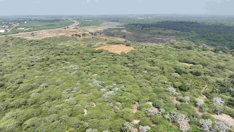
Illegal solar push ravages Hambantota elephant habitat: Environmentalist warns of deepening crisis
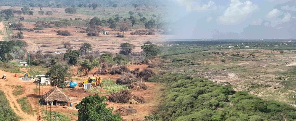
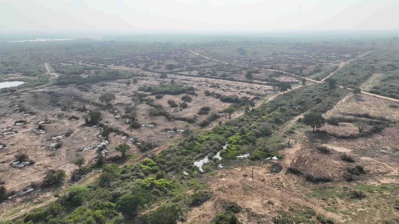
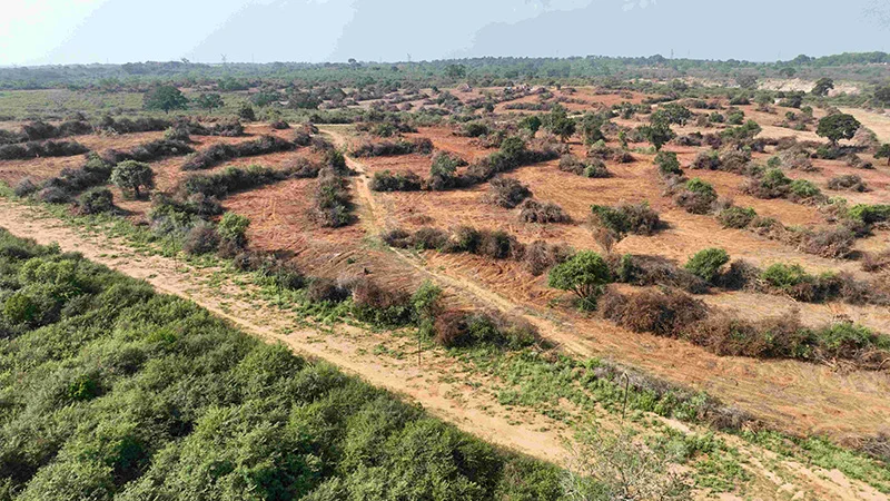
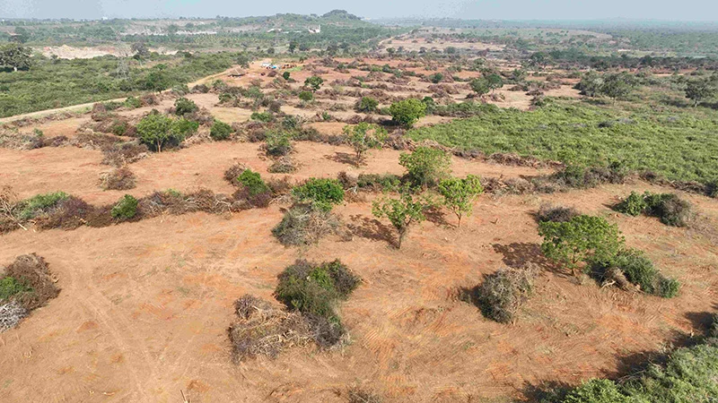
A large-scale move to establish solar power plants in Hambantota has triggered a major environmental and social crisis, with more than 1,000 acres of forest—identified as critical elephant habitat—cleared in violation of the law, environmental activist Sajeewa Chamikara said.
Chamikara, speaking on behalf of the Movement for Land and Agricultural Reform, said that 17 companies have already begun clearing forest land along the boundaries of the Hambantota Elephant Management Reserve. The affected areas include Sanakku Gala, Orukemgala and Kapapu Wewa, which are known to be key elephant habitats and long-used movement corridors.
He said that what is taking place cannot be described as development, but rather as a large-scale destruction of natural ecosystems carried out under the cover of renewable energy expansion.
According to Chamikara, the clearing of forests has been carried out using heavy machinery, while large sections have also been deliberately set on fire to prepare the land for solar installations. He said that electric fences have been erected across wide stretches of land, effectively blocking elephant movement and fragmenting their natural habitat.
“These forests are not empty lands. They are part of a living system that supports wildlife and nearby communities. Once destroyed, they cannot be easily restored,” he said.
The projects in question include a 50 megawatt solar development undertaken by five companies and a larger 150 megawatt project implemented by 12 companies. The larger project is reported to be valued at around 150 million US dollars.
Chamikara stressed that these projects are being carried out in a coordinated manner and involve extensive land clearing on a scale that raises serious environmental concerns.
He further alleged that certain companies had paid about Rs. 14 million to secure support and move ahead with the projects. He said this points to a troubling failure of oversight by state institutions that are expected to protect forests and wildlife habitats.
“This is not only an environmental issue. It is also a serious governance issue. The institutions responsible for protecting these lands have failed in their duty,” he said.
Chamikara pointed out that under the National Environmental Act, any project of this scale must receive prior approval through a proper Environmental Impact Assessment process.
He said that clearing forest land before obtaining such approval is a direct violation of the law.
He added that legal requirements relating to archaeological assessments had also been ignored. Under existing regulations, large-scale land clearing requires prior evaluation to ensure that sites of historical or cultural value are not damaged.
“The law is very clear. You cannot go ahead with projects of this nature without proper approval. What we are seeing is a complete disregard for legal procedure,” Chamikara said.
The environmental impact of these activities is already becoming visible. With their natural habitats destroyed, elephants are increasingly moving into nearby villages in search of food and shelter. This has led to a sharp rise in human-elephant conflict in several areas.
Areas such as Mayurapura, Gonnooruwa, Meegahajandura and Thanamalvila have reported increasing encounters between humans and elephants. According to Chamikara, more than 5,000 farming families in these areas are now facing growing threats to their safety and livelihoods.
He warned that farmers are being forced to abandon their lands due to repeated elephant intrusions, while incidents involving damage to crops and property are rising. There have also been increasing reports of injuries and deaths among both humans and elephants.
“This is turning into a serious social and economic problem. When farmers cannot cultivate their lands, it affects food production, income and rural stability,” he said.
Chamikara also raised concerns about the broader environmental consequences of clearing forests for solar power projects. While renewable energy is promoted as a solution to reduce carbon emissions, he said that destroying forests undermines that goal.
“Forests play a key role in absorbing carbon dioxide. When you clear and burn them, you are increasing emissions, not reducing them. That defeats the purpose of promoting solar energy,” he explained.
He added that large-scale deforestation in dry zone areas such as Hambantota could also affect local weather patterns and reduce rainfall, which would have further negative impacts on agriculture and water resources.
Chamikara called for a shift in policy, urging authorities to focus on more sustainable approaches to solar power development. He said that rooftop solar systems on homes, public buildings and commercial establishments should be given priority, as they do not require clearing large areas of land.
He also recommended that solar projects be located on degraded or abandoned lands, such as areas affected by past mining or other low-value lands, rather than forests or productive agricultural areas.
“Renewable energy development must be done in a way that does not destroy the environment. There are better options available if there is proper planning,” he said.
Chamikara urged the Central Environmental Authority and the Department of Wildlife Conservation to take immediate action to stop ongoing land clearing and investigate the projects. He stressed that all activities carried out without proper approval should be halted until legal requirements are met.
He warned that failure to act now would lead to long-term environmental damage that could not be reversed.
“If this continues, we will lose not only forests and wildlife, but also the balance between people and nature that supports rural life. The consequences will be felt for generations,” he said.
The situation in Hambantota is fast emerging as a critical test of whether development goals can be balanced with environmental protection. As pressure grows, the response of authorities in the coming weeks is likely to determine whether the damage can still be contained or whether it will continue to spread unchecked.
By Ifham Nizam

CEYPETCO Fuel prices increased from midnight today (21)

Advisory for Severe Lightning issued for Galle, Matara, Kaluthara and Rathnapura districts

Sri Lanka says it denied US request to land two aircraft at Mattala airport

Eid celebrations dimmed by war and displacement across Middle East

Showers may occur at several places in the Western, Sabaragamuwa, Northwestern and Uva provinces and in Galle, Matara, Kandy and Nuwara-Eliya districts after 1.00 pm.

Iranian strikes on bases used by US caused $800m in damage, new analysis shows

‘Dates have the highest sugar content to fight Coronavirus’

Sunday Island 27 December – Headlines

#SundayIsland 17th December – Headlines

Sunday Island – 28th March

Sunday Island Headlines – 21 March

Sunday Island – 21st February – Headlines
-

 Business6 days ago
Browns EV launches fast-charging BAW E7 Pro at Rs. 5.8 million
-

 Life style7 days ago
From culture to empowerment: Indonesia’s vision for Sri Lanka
-

 News4 days ago
CIABOC questions Ex-President GR on house for CJ’s maid
-

 Life style7 days ago
Ranjith Fernando celebrates cricketing journey with Hob Nails to Spikes
-

 News5 days ago
Sri Lankan marine scientist Asha de Vos honoured at UNGA opening
-

 Features6 days ago
Achievements of the Hunduwa!
-

 Latest News7 days ago
QR code system will be implemented for fuel with effect from 06.00 a.m. today (15th)
-

 News5 days ago
Australian HC debunks misleading travel risk claims for Sri Lanka